
Zane Heading Towards Queensland Australia
.jpg)
Cyclone Zane, which as of 12:00 UTC (10:00 pm Australian Eastern Standard Time or AEST) 1 May 2013, was located about 215 km (~133 miles) due east of the coast of Queensland, Australia.
TRMM captured this recent image of Cyclone Zane at 11:48 UTC (9:48 pm AEST) 1 May 2013. At the time, the center of circulation was located about 215 km (~133 miles) due east of the coast of Queensland, Australia and was heading west-northwest. TRMM reveals that Zane is still not very well organized with no eye visible and very little evidence of banding (curvature) in the rain area. At the time of this image, Zane was (and currently still is) a Category 1 cyclone (equivalent to a tropical storm on the US Saffir-Simpson scale) with sustained winds reported at 45 knots (~52 mph) by the Australian Bureau of Meteorology's Tropical Cyclone Warning Centre.
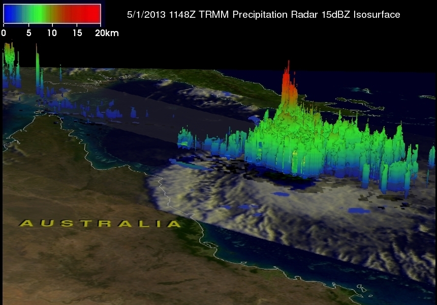
The second image shows a 3D picture of Zane from the TRMM PR. Although Zane has an area of active deep convection reaching upwards of 15 km (shown in red), it is located away from the center of circulation and so does not necessarily preclude further strengthening. Zane is expected to weaken due to unfavorable wind shear before crossing the coast of northern Queensland north of the Lockart River during the day tomorrow.
Click here to see a TRMM Precipitation 3-D flyby Quicktime animation of Zane.
Click here to see a TRMM Precipitation 3-D flyby MPEG animation of Zane.
Images produced by Hal Pierce (SSAI/NASA GSFC) and caption by Steve Lang (SSAI/NASA GSFC).