
Why was the GMI Off-Nadir angle of 48.5° chosen?
At the start of the modern passive microwave age, the Defense Meteorological Satellite Program (DMSP) Special Sensor Microwave/Imager (SSM/I) was designed to give an Earth Incidence angle (EIA) around 53°. The design parameters for SSMI were generated by Jim Hollinger, at NRL at the time, and meant to address several Earth science variables, not just precipitation. For EIAs around 53°, the roughness component of the wind speed signal is nearly zero in vertical polarization. Starting around wind speeds of 5 m/s wave action starts to generate foam, which depolarizes the signal, so this consideration is less important for higher speeds. Note that 53° is also in the range of giving good separation between the vertical and horizontal polarization channels (see this image, https://pmm.nasa.gov/sites/default/files/imce/SSMI_pol-vs-incidence.jpeg). One not-relevant factor is the Brewster angle for the air/water interface, at which reflected radiant energy is purely horizontally polarized. For visible wavelengths this is close to 53°, but for microwave frequencies it's up around 80°, and so not relevant to SSMI design. Given the ~800 km altitude of the DMSP, the look angle for the SSMI has to be 45° for an EIA of 53° (due to the curvature of the Earth). Then the TRMM Microwave Imager (TMI) was designed and given the same EIA, which simplifies instrument intercomparison and has the same wind speed characteristics. At TRMM's lower altitude, originally 350 km, that required a look angle of 48.5°. GPM is in a similar orbit, so its viewing geometry is the same. The gotcha on GMI, which has multiple feed horns (see below image) is that the feed horns are clustered, and therefore stare into the reflector at slightly different angles, yielding slightly different look angles and EIAs.
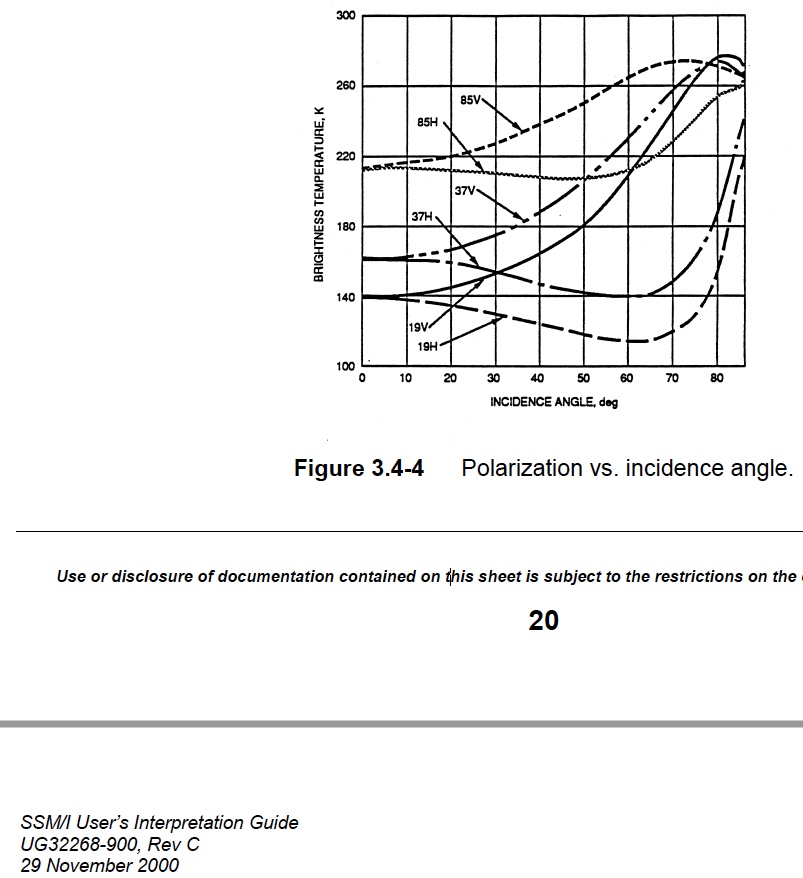
Image of polarization vs. incidence angle.
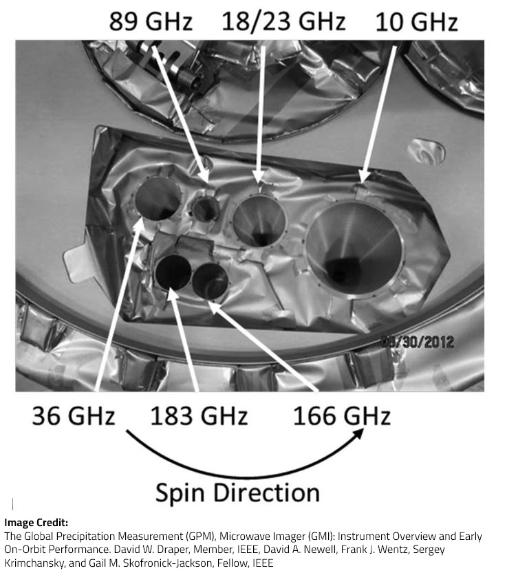
Photograph of the feed horn layout on the GPM Microwave Imager instrument (GMI). Learn more about the GMI.
But, as we've gotten more sophisticated about this stuff, it turns out that having similar EIAs is nice, but in fact we now consider the EIA variations, both between sensors, and for the same sensor due to altitude changes (particularly the TRMM altitude boost to 402.5 km nominal in 2001) and the variations in Earth shape seen by the sensors in ordinary operation.