

Thunderstorms Rumble over the Great Plains
During the summer, the U.S. Great Plains routinely experiences nighttime thunderstorms unlike anywhere else in the country. These large-scale storms—sometimes spanning entire states—account for more than 40 percent of annual rainfall in some areas. They can bring much-needed rain to farms and help recharge aquifers, but extremely severe events can also destroy fields, homes, and lives. Scientists have been studying the region for decades to learn the underpinnings of this distinct, repetitive weather pattern.
“In the summer, the Great Plains receives half of its rainfall during the nighttime,” said Kris Bedka, a climate scientist at NASA’s Langley Research Center. “This is very different from the Southeast and mid-Atlantic U.S. that receive the vast majority of rainfall during the day.”
The animation above shows the typical rainfall patterns across a 24-hour period during the summer months (June, July, and August) in the Midwest. The precipitation rate is calculated every half hour and averaged across 18 years of data (2000-2018) from the Integrated Multi-satellitE Retrievals for GPM (IMERG) algorithm. As one of the longest continuous records of high-resolution satellite precipitation data, the IMERG product combines data from the Tropical Rainfall Measuring Mission (TRMM) satellite, which operated from 1997 to 2015, and the Global Precipitation Measurement (GPM) satellite, which has been collecting data since 2014. Both missions were joint efforts between the Japanese Aerospace Exploration Agency (JAXA) and NASA.
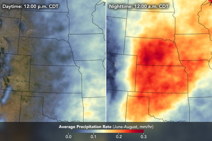
“The rainfall begins as a band east of the Rocky Mountains in the afternoon, and then propagates over the Great Plains at nighttime,” said Jackson Tan, a researcher with USRA at NASA’s Goddard Space Flight Center who helps develop IMERG products. “The maximum rainfall occurs early morning near Nebraska, Iowa, and Kansas.” Note the severe thunderstorms across the Eastern U.S. the following day, which occur due to the hot and humid conditions and circulation patterns during the summertime.
One important ingredient for the thunderstorm activity is the nocturnal low-level jet stream, according to Bedka. The low-level jet is a fast-moving stream of air—traveling up to 80 miles (130 kilometers) per hour—located within 1,600 feet (500 meters) of the ground. The jet accelerates due to temperature contrasts at night. When the Sun sets, the atmosphere at the ground cools while leftover warm and moist air settles on top of the cool air, creating layers in the atmosphere. As a result, winds even just a mile above the ground are no longer slowed down by frictional forces from the land below and become decoupled. The winds intensify into the feature known as the low-level jet stream.
The nocturnal low-level jet stream transports warm, moist air—which blows in from the Gulf of Mexico or gets evaporated from farmland—to the lee side of the Rocky Mountains. The mountain range regularly experiences afternoon thunderstorms in the summer. The warmth and moisture from the jet stream help fuel these thunderstorms and turn them into large, broad thunderstorm clusters called mesoscale convective complexes (MCCs). Winds in the middle troposphere, 3-6 kilometers above the surface, typically have a more westerly component that steer the MCCs across the Plains.
“These huge nighttime thunderstorm clusters that occur almost daily across the Midwest are caused by a unique convergence of atmospheric ingredients, and are responsible for a variety of hazardous weather conditions,” said Bedka. MCCs can cause deadly lightning, severe downpours, destructive winds, and tornadoes.
The thunderstorms mostly disappear during the day as the low-level jet stream dissipates. As the Sun heats the land, the lower atmosphere mixes with the upper atmosphere. The stream decelerates as it encounters friction with the surface and cuts off the dynamics that fuel the storms, causing them to fall apart. But, small low-pressure circulations generated by MCCs called mesoscale convective vortices persist long after the parent MCC decays, which can then spawn new severe storms the following afternoon across the Eastern U.S.
NASA Earth Observatory images and video by Joshua Stevens, using Global Precipitation Measurement (GPM) Mission data courtesy of Jackson Tan/USRA/NASA/GSFC. Story by Kasha Patel.