SMAP

Using NASA Satellite Data to Predict Malaria Outbreaks
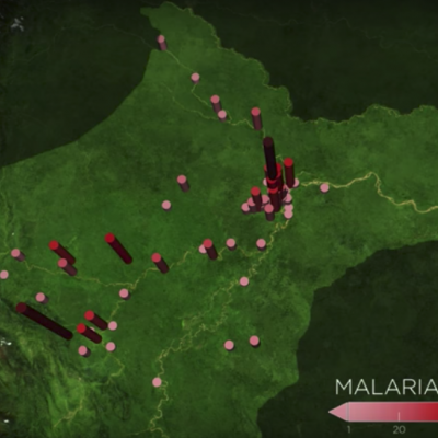
In the Peruvian Amazon, the Anopheles darlingi mosquito is most responsible for spreading malaria. With funding from NASA's Applied Sciences Program, scientists are turning to the agency’s fleet of Earth-observing satellites to develop a system that uses satellite and other data to help forecast malaria outbreaks at the household level months in advance and prevent them from happening. Credits: NASA's Goddard Space Flight Center / Joy Ng In the Amazon Rainforest, few animals are as dangerous to humans as mosquitos that transmit malaria. The tropical disease can bring on high fever, headaches...
The Evolution of NASA Precipitation Data
NASA’s global precipitation data and data processing systems have come a long way from the launch of TRMM in 1997 to the ongoing GPM mission. Just before midnight Eastern Daylight Time on June 15, 2015, a fireball appeared over central Africa, streaked across Madagascar, and tracked across the uninhabited Southern Indian Ocean. This was the fiery end of the joint NASA/Japan Aerospace Exploration Agency (JAXA) Tropical Rainfall Measuring Mission (TRMM). TRMM’s homecoming after more than 17 years in orbit also marked the end of the first major satellite mission specifically designed to gather...