In-Fa

Typhoon IN-FA's Extreme Rainfall Measured By GPM

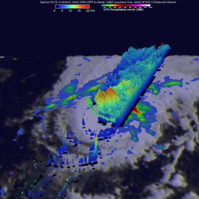
Typhoon IN-FA's peaked as a category four tropical cyclone on the Saffir-Simpson scale with maximum sustained winds of about 115 kts (132 mph) on November 21, 2015. IN-FA's winds had decreased to about 90 kts (103.5 mph) when the GPM core observatory satellite flew over on November 23, 2015 at 1555 UTC. Measurements by GPM's Dual-Frequency Precipitation Radar (DPR) instrument indicated that IN-FA was dropping rain at an extreme rate of over 266 mm (10.5 inches) per hour in storms just to the northwest of the typhoon's eye. GPM's radar (DPR Ku Band) were used to show the 3-D structure of

GPM Sees Better Organized Typhoon IN-FA

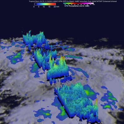
The GPM core observatory satellite had another excellent view of typhoon IN-FA on November 19, 2015 at 0305 UTC. This GPM pass revealed the location of typhoon IN-FA's eye beneath dense overcast. Rainfall derived from data collected by GPM's Microwave Imager (GMI) and Dual-Frequency Precipitation Radar (DPR) instruments show that feeder bands around IN-FA were getting better organized. The most intense precipitation was measured in IN-FA's eye wall by DPR where it was falling at a rate of almost 55 mm (2.16 inches) per hour. Most rainfall in feeder bands was shown by GPM to be only light to

GPM Monitors Western Pacific Typhoon IN-FA

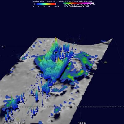
On November 18, 2015 at 1533 the GPM core observatory satellite flew directly over a recently formed typhoon called IN-FA that was located near the Equator well to the southeast of Guam. Favorable environmental conditions such as low vertical wind shear and warm sea surface temperatures helped typhoon IN-FA intensify quickly from a tropical depression on November 17 to a typhoon on November 18, 2015. Rainfall from GPM's Microwave Imager (GMI) and Dual-Frequency Precipitation Radar (DPR) instruments were used to analyze the rainfall around typhoon IN-FA. GPM's DPR found that rain was falling at