Hide Title

IMERG precipitation map from 11-6-19
This page provides a directory of download links, documentation, and other details about data products produced by NASA's Global Precipitation Measurement Mission (GPM) and Tropical Rainfall Measuring Mission (TRMM).
2019 Hurricane Season Banner
NASA has a unique and important view of hurricanes around the planet. Satellites and aircraft watch as storms form, travel across the ocean and sometimes, make landfall. After the hurricanes have passed, the satellites and aircraft see the aftermath of hurricanes, from downed forests to mass power loss.
Thumbnail
NASA’s Precipitation Measurement Missions consist of TRMM and GPM. The Global Precipitation Measurement Mission (GPM) is an international satellite mission launched by NASA and JAXA on Feb. 27th, 2014 that is setting new standards for precipitation measurements worldwide. Using a network of satellites united by the GPM Core Observatory, GPM expands on the legacy of the Tropical Rainfall Measuring Mission (TRMM, 1998 - 2015) by providing high quality estimates of Earth’s rainfall and snowfall every 30 minutes.
Thumbnail
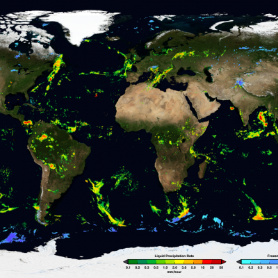
The Global Precipitation Measurement (GPM) mission has several cross-cutting application areas which contribute to and enhance our understanding of weather forecasting, disasters, ecology, health, water and agriculture and energy. Using advanced space-borne instruments, GPM measures light rain to heavy rain and falling snow, producing a near-global view of precipitation every 30 minutes. Through improved measurements of rain and snow, precipitation data from the GPM mission is used by a diverse range of applications and user communities at local to global scales to inform decision making and policy that directly benefits society.