Hide Date

Attendees of the 2019 PMM Science Team Meeting
2022 PMM Science Team Meeting Group Photo
IMERG precipitation map from 11-6-19
This page provides a directory of download links, documentation, and other details about data products produced by NASA's Global Precipitation Measurement Mission (GPM) and Tropical Rainfall Measuring Mission (TRMM).
Thumbnail
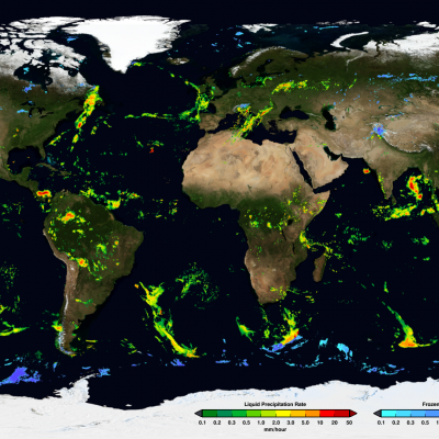
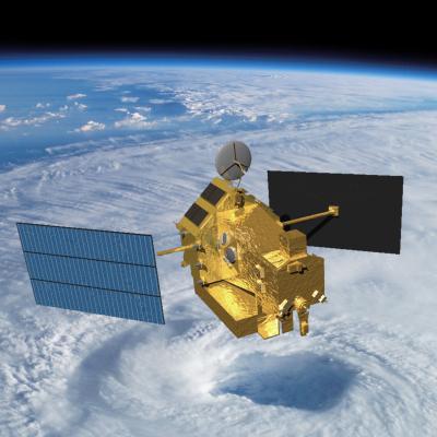
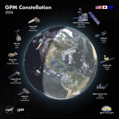
The Global Precipitation Measurement (GPM) mission is an international network of satellites that provide next-generation global observations of rain and snow. Building upon the success of the Tropical Rainfall Measuring Mission (TRMM), the GPM concept centers on the deployment of a “Core Observatory” satellite carrying an advanced radar / radiometer system to measure precipitation from space and serve as a reference standard to unify precipitation measurements from a constellation of research and operational satellites. Through improved measurements of precipitation globally, the GPM mission is helping to advance our understanding of Earth's water and energy cycles, improve forecasting of extreme events that cause natural hazards and disasters, and extend current capabilities in using accurate and timely information of precipitation to directly benefit society. GPM, initiated by NASA and the Japan Aerospace Exploration Agency (JAXA) as a global successor to TRMM, comprises a consortium of international space agencies, including the Centre National d’Études Spatiales (CNES), the Indian Space Research Organization (ISRO), the National Oceanic and Atmospheric Administration (NOAA), the European Organization for the Exploitation of Meteorological Satellites (EUMETSAT), and others.
GPM Constellation Banner
Co-led by NASA and the Japan Aerospace and Exploration Agency (JAXA), the Tropical Rainfall Measurement Mission (TRMM) and Global Precipitation Measurement (GPM) mission have built unprecedented international cooperation in space asset sharing and scientific collaboration to advance precipitation estimation from space for research and applications. GPM is an international satellite mission specifically designed to unify and advance precipitation measurements from research and operational microwave sensors for delivering next-generation global precipitation data products. The GPM mission
AGU24 Hyperwall
Beginner Training Sessions Overview of Global Precipitation Measurement (GPM) Mission, Data Products and Data Access Tools Topics Covered: Learn about the GPM Core Observatory satellite: Orbital Configuration, Sensors ( GMI, DPR) GPM Constellation Satellites Learn about GPM precipitation data products: Level-2 to Level-3 Data Sets from GMI, DPR and Combined GMI-DPR, IMERG Filename Conventions, Formats Spatial and Temporal Resolutions and Coverage Data Search and Access Web-tools Data Quality Potential Data Applications Training Resources: View a recording of the webinar Download the webinar
GPM Applications: Weather
Using GPM Data for Weather, Climate, and Land Surface Modeling Variations in rain, snow, and other forms of precipitation are an integral part in everyday weather and long term climate trends. Initialization of short-term weather and long-term climate models with accurate precipitation information enhances their prediction skills and extends their skillful lead times. To get the resolution and temporal coverage to measure precipitation across the globe, we often rely on satellite information. Satellite data can play a fundamental role in our ability to monitor and predict weather systems as
GPM Applications: Water & Agriculture
Growing human population, increased demand for water and energy, and a changing climate have contributed to concerns of how freshwater resources and food supply and production may be stressed. Both water resource managers and the agricultural community need to know the amount, distribution, timing and onset of seasonal rain and snow to prepare for freshwater shortages and forecast crop yields. Remotely sensed precipitation estimates play a key role in predicting changes in freshwater supply and agricultural forecasting. Specifically, GPM provides advance precipitation measurements on regional
GPM Applications: Energy
In many areas, energy infrastructure assets, such as power plants and electric grids, can suffer damage or disruption in service due to a variety of climate-related impacts like extreme precipitation, high temperatures, drought, and rising sea levels. For example, warmer temperatures and little rainfall can cause changes in peak streamflow conditions that affect hydropower generation. Heavy precipitation events and flooding can impact a region’s energy infrastructure, including electric grid equipment, which has cascading effects on freshwater supplies and emergency services. The Energy