
Shedding Light on the Future of Earth's Climate with NASA Data
Climate researchers around the world are taking advantage of NASA satellite observations to help inform, improve, and enhance climate models. NASA data helps to predict the future of Earth's climate and improve the predictive capability of models. This gives decision-makers the tools they need to make better decisions on how we live, including understand the changing impacts of hurricanes and improving predictions of fire seasons.
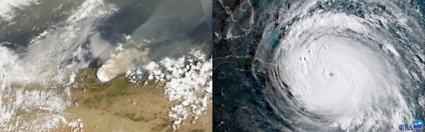
Examples of the impacts of disasters linked to climate change. From left to right, wildfires in Algeria (Credit: NASA Earth Observatory, Lauren Dauphin) and Hurricane Irma. Credits: NOAA / CIRA
But how exactly does NASA data support climate modeling activities, and how does the data improve these models? We’re here to explain the inner workings of how NASA data, such as precipitation data from NASA’s Global Precipitation Measurement (GPM) mission, is shedding light on predicting the future of Earth's climate, and how this data is making an impact on local and global scales.
Essentially, climate models help capture atmosphere, land, ocean, and ice processes - such as ocean circulation and global precipitation patterns - and the interactions among them. The models are typically generated from mathematical equations that use thousands of data points to ultimately simulate Earth’s water and energy cycles. This information allows researchers to test hypotheses and draw conclusions on past and future climate systems.

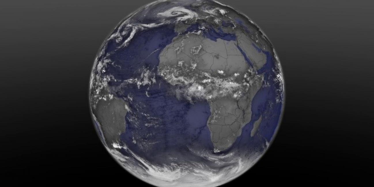
The image shows cloud cover as modeled by the NASA GEOS-5 atmospheric model. Credits: NASA
Data from NASA feed into climate models at a variety of national and international organizations including NASA, National Oceanic and Atmospheric Administration (NOAA) and the Japan Meteorological Agency. “NASA is a leader in making space-based measurements of climate variables, including precipitation, cloud coverage, water vapor, and temperature, over long periods of time,” said Greg Elsaesser, a research scientist at the NASA Goddard institute for Space Studies (GISS) and Columbia University. Elsaesser uses satellite observations to improve global climate models. Unlike ground-based monitoring tools that do not provide adequate coverage in many regions of the world, satellites provide a consistent, global view of environmental variables that influence Earth’s climate.
These organizations utilize NASA data using a series of techniques including model parametrization development, data assimilation and validation, all of which are critical to evaluate and improve their agency’s climate models. These activities can strongly impact the accuracy of forecasts, which enable models to predict weather averages on the shorter time scales, ranging from sub-seasonal-to-seasonal (S2S) and interannual, and climatic properties such as atmosphere-ocean cycles for several years and decades in the future. This gives stakeholders the best available science to guide their decisions that directly impact society.
How does Precipitation Data Support Climate Model Development?
When creating climate models, scientists want to capture the Earth system as a whole. One critical variable is precipitation. Precipitation plays a crucial part in the Earth’s water and energy cycles, which directly affect and are impacted by a changing climate. When precipitation undergoes phase changes between vapor, liquid, and frozen states, energy in the form of latent heat is released or absorbed, which can fuel hurricanes and storms. Precipitation accumulations and changes also impact ice sheets and glaciers, rivers and lakes, and vegetation, all of which influence variations in the Earth’s water and energy cycles. As such, satellite observations of precipitation and indirect measurements of latent heating can provide useful information about the climate system to advance climate modeling.
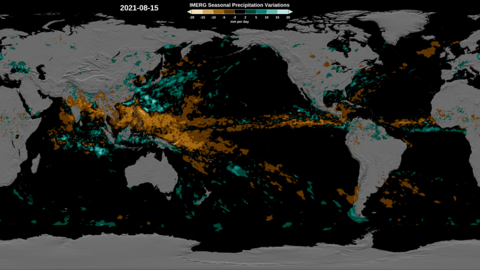
The Integrated Multi-satellite Retrievals for GPM product (IMERG) provides global estimates of rain and snow. The IMERG dataset starts in June 2000, providing a sufficiently long record that seasonal / regional averages, or climatology, can be computed with reasonable confidence. By comparing the progression of the observed precipitation with climatology, we can generate maps showing how much observations depart from the average. This image shows variations from the average precipitation on August 15, 2021, where blues indicate higher observed rainfall and browns indicate lower observed rainfall compared to the average. Click here to learn more. Credits: NASA Goddard Scientific Visualization Studio
NASA’s GPM mission is supporting these efforts by providing critical measurements of precipitation rates and derived latent heating estimates for climate modeling applications. GPM provides advanced measurements of precipitation - from light rain, to heavy rain to, falling snow - with instruments that estimate the microphysical properties of individual raindrops and snowflakes.
“The GPM satellite may revisit any one location on Earth every few days. Because weather is so variable at many locations, the GPM satellite may measure anything from no precipitation to intense rainfall associated with thunderstorms to snowfall and running the gamut in between! There are a number of ways to use these diverse GPM precipitation measurements in climate modeling,” says Elsaesser.
Model Parametrization
GPM measurements can be combined with other environmental data collected from NASA and partner satellites and comprehensively analyzed with the goal of improving the governing equations in climate models that represent precipitation and other environmental variables. These equations are then translated to computer code to inform and develop a climate model, making it more realistic in simulating the Earth system. The development and improvement of these equations is often referred to as "climate model parameterization development".
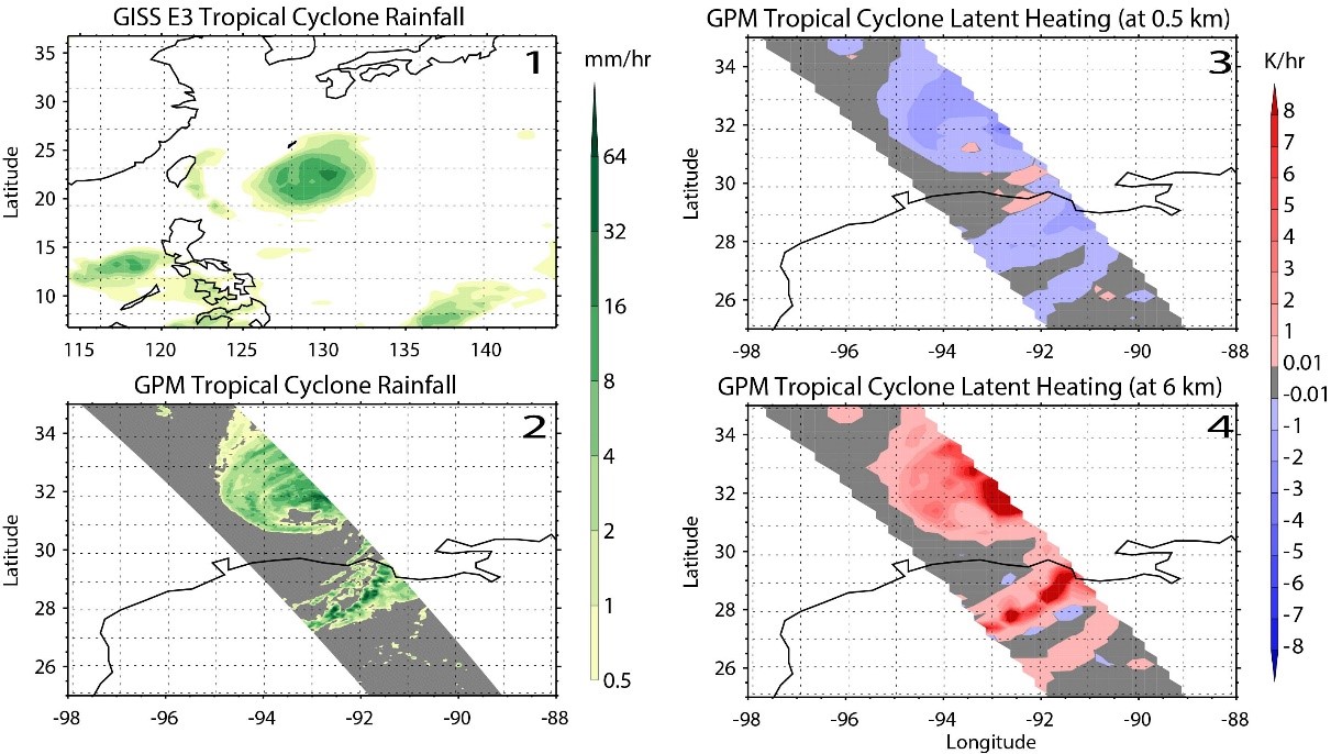
An example showing tropical cyclones in climate model simulations. Panel 1 (upper left) shows a simulated tropical cyclone using the GISS E3 climate model. Panel 2 (lower left) shows rainfall estimates using the IMERG product, Panels 3 and 4 (upper right and lower right) show examples of latent heating using GPM’s Convective-Stratiform Heating (CSH) Level 2 product at different altitudes associated with the Hurricane Laura in 2020. It is important to see if tropical cyclones in the climate model are producing rainfall rates and latent heating amounts comparable to what is observed by GPM. This is because different amounts of heating and cooling impact local air circulations and subsequent rainfall development. So, not only do climate models need to get rainfall right, they need to get heating and cooling variations so that the impacts on air circulation are as accurate as possible. Analyzing both rainfall and latent heating at various altitudes allows for a more comprehensive evaluation of climate model processes and phenomena such as tropical cyclones. Credits: NASA / Greg Elsaesser (GISS)
As an example, a pressing issue for climate models is to simulate atmospheric circulation, which is strongly tied to precipitation and storm system tracks. When precipitation undergoes phase changes (i.e., between vapor, liquid, and frozen states), it results in energy being released or absorbed (i.e., changes in latent heating), which has a strong impact on atmospheric circulation. As such, GPM measurements are used to derive estimates of latent heating at various levels of the atmosphere and its connection to observed atmospheric circulation, as illustrated in the above image. Climate models resolving precipitation and latent heating at the altitudes observed by GPM will not only have improved simulation of circulations, but more accurate predictions of storm tracks.
Data Assimilation
GPM data, along with other NASA data products, are also used as initial conditions of the environment that climate models incorporate using data assimilation techniques. This is necessary to further develop model parameters and start a climate model “run”. Scientists use many different observations that are available in near real-time, such as the GPM Microwave Imager (GMI) radiance data, to better estimate the current state of the Earth system and inform a model.
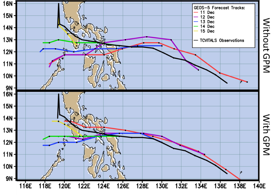
Forecast tracks for Typhoon Melor (2015) showing the impact of incorporating radiances in all-sky (precipitating and clear) conditions from the GMI instrument. The model which integrated GPM data (bottom) was shown to reduce the spread in the forecasts over the lifespan of the system, resulting in a more consistent and accurate set of forecasts. Credits: NASA / Min-jeong Kim (GMAO/GESTAR)
“Assimilating GMI radiances improve intensity and location estimates of storms and precipitation calculated by the climate models, and improve forecasts of other dynamic variables such as winds, temperature, and surface pressures in the Goddard Earth Observing System (GEOS) model,” says Dr. Min-jeong Kim, a research scientist within NASA’s Global Modeling Assimilation Office (GMAO) and Morgan State University. Dr. Kim uses satellite observations to better simulate and predict Earth’s climate conditions.
Validation
Since scientists cannot wait years or decades to see if their models are accurately projecting the future climate system, they must test a model’s accuracy using past events. Another way scientists describe this effort is "validating climate model outputs". Past precipitation measurements can be averaged over a span of years or decades to show patterns and trends of global precipitation over time, which is used to help generate a precipitation climatology. This satellite-observation-based precipitation climatology is then compared to a climate model’s simulated precipitation climatology, with the purpose of determining whether the climate model can accurately represent what satellites are observing over a long period of time.
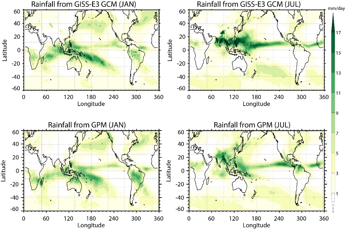
Average precipitation patterns from 2014 - 2020 during winter (January, left) and summer (July, right) using the GISS-E3 climate model (top) and precipitation estimates derived from GPM’s multi-satellite IMERG product (bottom). These images show how rainfall drastically increases over southern Asia from January to July, along with a shift in the peak intensity of rainfall in the eastern U.S. from over the ocean (in January) toward land (in July). The GISS-E3 climate model successfully simulates these patterns observed by GPM. However, GPM also observed rainfall shifting from central South America in January toward northern South America in July and the GISS-E3 climate model does not simulate this rainfall pattern very well. Climate models such as the GISS-E3 must accurately simulate these seasonal cycles observed by GPM in order for their predictions of future climate to be more reliable. Using the GPM rainfall observations as benchmarks, new model equations are being worked on to improve this area of rainfall simulation. Credits: NASA / Greg Elsaesser (GISS)
In the above image, a model “run” using NASA’s global climate model, GISS-E3, is compared against seasonal rainfall patterns observed by GPM to determine whether the model can successfully simulate GPM observations. Climate models such as GISS-E3 must accurately simulate these seasonal cycles in order for their predictions to be more reliable. If the climate model disagrees with the satellite climatology, then a model developer can adjust various physics parameters in the model, re-run the simulation, and determine if the simulated climatology improves.
NASA satellites have collected a wide variety of information about the pulse of our planet for several decades, including precipitation, air quality, ocean health and storm data, which are all vital for understanding how Earth’s systems functioned in the past and will continue to function in the future. This information, combined with modeling techniques, allows us to improve the predictive capability of models, affecting our ability to plan and make informed decisions for the adverse effects of climate change.
Learn More About NASA Climate Modeling
Interactive Story Maps
One Pagers
Precipitation Education:
Credits:
Story by Andrea Portier (NASA GSFC / SSAI)