

Using the IMERG Long-term Precipitation Dataset for Applications
A long precipitation data set like the new GPM IMERG V06 product is valuable for many applications and for decision-making. Accurate and reliable precipitation records are not only crucial to understanding trends and variability but also for water management resources and food security, ecological management, and weather, climate and hydrological forecasting. Here we present a few highlights showcasing how GPM IMERG is helping a variety of end users make decisions that will benefit society for years to come.
GPM IMERG Data Used for Wind Energy
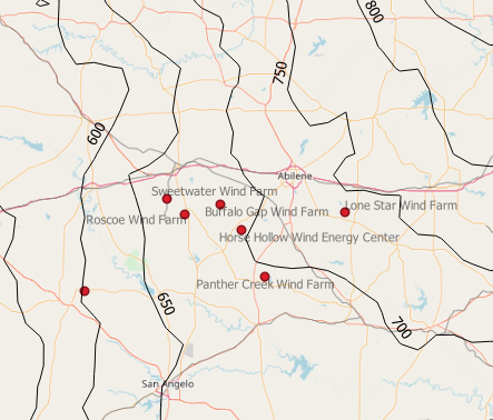 Map of average precipitation in north-central Texas depicted by black contour lines using GPM IMERG data. Image credit: Laurids Andersen, LM Wind Power.
 Individual components of wind turbines, especially the rotor blades, are expected to have an operational life span of 20 years while facing environmental extremes such as precipitation. These extremes can lead to corrosion on the leading edges of the blades and reduce the overall efficiency of converting wind into energy. To understand how weather impacts wind turbine blades in Texas, LM Wind Power (a supplier of wind turbine blades worldwide) is using GPM IMERG’s 19-year precipitation record to develop contour precipitation maps and determine average precipitation at existing and potential wind turbine site locations. This information will help LM Wind Power gather information on blade reliability and performance to satisfy their customers.
Response from LM Wind Power’s Laurids Andersen to using GPM IMERG: “A global historical overview of the accumulated rain and rain intensity the turbines have been rotating in helps us with valuable information on how much rain our different coatings can withstand at different tip speeds.”
GPM Supports Insurance Companies
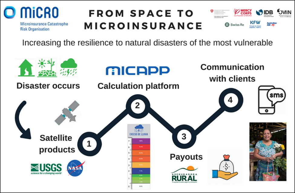 MiCRO’s flow chart depicting how they determine the amount of a payment to insured clients when a disaster strikes: NASA satellite data (1) is used to design payout triggers (2). When disasters occurs and depending on its severity, payment is determined (3) and clients are informed via text (4). Image credits: Iker Llabres on behalf of MiCRO (www.microrisk.org)
Unexpected shocks from natural hazards can affect vulnerable low-income individuals and force them to cope with losses by selling assets. Microinsurance is a type of insurance product that helps low-income individuals manage their risks. As one example, helping over 20,000 individuals and their families throughout Central America, the Microinsurance Catastrophe Risk Organization (MiCRO) is using NASA satellite data to help forecast the probability of natural hazards. Specifically, MiCRO is using GPM IMERG precipitation data to identify the amount of rainfall over a specific time period. This data is then compared against historical averages to design payout triggers of index-based insurance products. Policyholders are compensated according to the strength of the measured event against those triggers.
Response from MiCRO’s Iker Llabres to using GPM IMERG: “The availability of long IMERG precipitation dataset allows us to better identify rainfall extremes in our pilots and enables better calibration of our parametric insurance products.”
Assessing Drought on the Navajo Nation
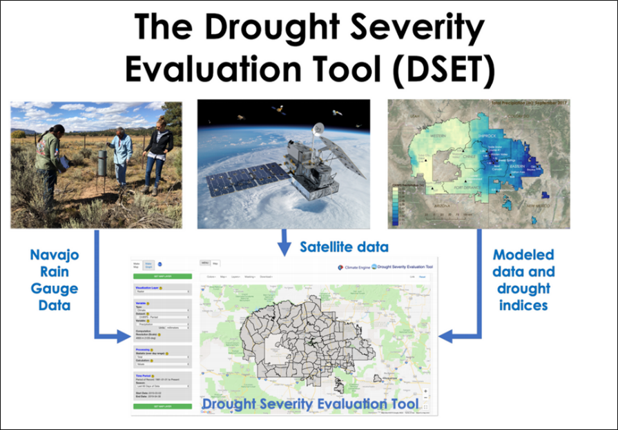 The Drought Severity Evaluation Tool (DSET) and the information that will be inputted into the tool. Text and Image Credit: Amber Jean McCullum1, Justin Huntington2, Britta Daudert2, Carlee McClellan3 (1Bay Area Environmental Research Institute/NASA Ames Research Center, 2Desert Research Institute, 3Navajo Nation Dept. of Water Resources).
The Navajo Nation (NN), located in the Four Corners Region of the United States, is the largest federally recognized tribe in land area and faces challenges related to water management during long-term droughts. Currently, the Navajo Nation Department of Water Resources (NNDWR) reports on drought and climatic conditions through the use of regional Standardized Precipitation Index (SPI) values and a network of in-situ rainfall and climate data. However, these data sources lack the spatial detail and consistent measurements needed to provide a coherent understanding of the drought regime within the Nation’s boundaries. The use of satellite-based remote sensing of precipitation, vegetation, and drought indices on the NN may improve upon the ability to monitor and report drought conditions. A team of researchers from NASA, Desert Research Institute (DRI), and NNDWR aim to create a cloud-based web application, the Drought Severity Evaluation Tool (DSET), for improved drought reporting that will include remotely-sensed, modeled, and in-situ data on the NN. This tool will harness the capabilities of Google Earth Engine (GEE), specifically through a partnership with the DRI and ClimateEngine.org, to conduct drought and land assessments. DSET connects NASA Earth Observations (including GPM IMERG), modeled climate data, and in-situ rain gauge data for on-the-fly analyses. DSET computing capabilities includes the generation of regional to field scale maps, time series figures, and reporting metrics that can assist in drought emergency declarations and the subsequent allocation of relief dollars across the NN.
Response from WWAO’s Amber Mccullum to using GPM IMERG: “The Western Water Applications Office (WWAO) Navajo Drought project anticipates incorporating IMERG V06 into our Drought Severity Evaluation Tool (DSET) to serve as a comparison to the Navajo Nation’s network of in-situ rain gauges. The IMERG V06 data will be used by our project partners to generate maps of total monthly precipitation for administrative boundaries with the hopes of including these data into monthly drought status reports.”