
Atmospheric River Brings Severe Flooding and Landslides to British Columbia
The Pacific Northwest coast saw two atmospheric rivers (ARs) bring heavy rains from Nov. 10-16, 2021, resulting in severe flooding, landslides, and damage to infrastructure in the British Columbia province of Canada. ARs are long, narrow corridors of water vapor that travel vast distances above the ocean from warm, tropical regions to higher latitudes, where they often release their moisture as rainfall when they reach land areas. While ARs occur across the globe, this year has been notable for several strong events that have impacted the Pacific Northwest coast. The two atmospheric rivers in November came just after three AR events in October 2021 that struck the U.S. West Coast, including two strong events and one “exceptional” event, according to the Center for Western Weather and Water Extremes (CW3E) at the University of California, San Diego.
Download video (right-click -> "Save As")
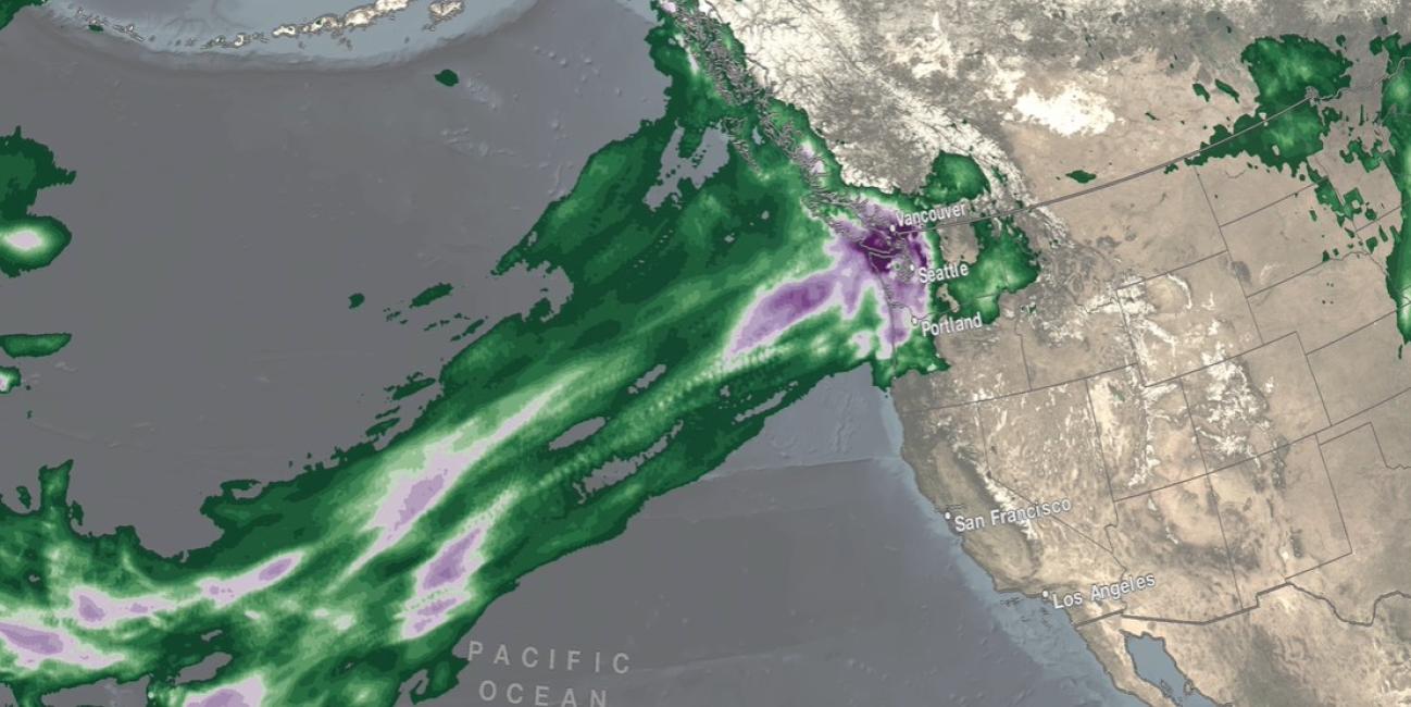
The November ARs can be seen in this animation of IMERG satellite rainfall estimates. Shades of blue/yellow show IMERG rain rates overlaid on cloudiness based on geosynchronous satellite infrared observations. Below the rainfall and cloudiness data, IMERG accumulations over the period are shown in shades of green/purple. The first AR can be seen from Nov. 11-12 wrapping around a low-pressure system over the Northeastern Pacific Ocean while delivering rainfall to the areas around Vancouver, Seattle, and Portland. The second AR can be seen from Nov. 13-16 as it develops and creates a line of clouds and precipitation that stretches from the Hawaiian Islands north to Vancouver. Rain rates near Vancouver exceeded 1 inch/hour (25 millimeters/hour) on Nov.15 at the peak intensity of the second AR, which the CW3E rated as a borderline Category 5 AR, the highest category assigned to an AR, which denotes primarily hazardous impacts instead of beneficial impacts. By the end of the animation, a third pulse of rain can be seen approaching the Pacific Northwest coast, foreshadowing even greater accumulations in the days to come. IMERG estimated that the two November 2021 AR events dropped more than 12 inches of precipitation in the 7-day period from Nov. 10-16 over a relatively concentrated area near Vancouver and Seattle, amounts which were broadly consistent with NOAA rain gauge measurements. By comparison, the October 2021 AR events spread their precipitation over a wide area extending from Northern California into British Columbia and Southeastern Alaska. British Columbia saw particularly devastating effects from the Nov. events, which came after a record-breaking heatwave this summer. That heatwave helped fuel wildfires that stripped vegetation and left burn scars across their paths, creating prime conditions for landslides. The cumulative effect of the October and November atmospheric rivers, which arrived just months after the heatwave and wildfires, led to saturated soils, flooding, and landslides across the region, with a state of emergency declared for British Columbia.
NASA’s IMERG product is a multi-satellite global estimate of rainfall produced in near real-time at half-hourly intervals. The global span of IMERG covers the oceans as well as land areas, which is a major advantage over ground-based radar and rain gauge measurements. Even for very fast-moving features like the rain bands moving above the ocean surface in this animation, the half-hourly updates of IMERG provide a relatively smooth picture of rain rates and accumulations over the entire event, which extends for thousands of kilometers over the Pacific Ocean. IMERG allows atmospheric scientists to study extreme weather events, such as the Oct. and Nov. 2021 ARs, and better understand the mechanisms that drive them, ultimately leading to better forecasting.
Credits:
Animation and story by Jason West (NASA GSFC / PPS / KBR, Inc.)