

Storm Brings Heavy Precip. to Northeast
UPDATE 1/23/2016 5:00pm ET
![]()
On January 23, 2016 at 1239 UTC (7:39 AM EST) the GPM core observatory passed above the deadly winter storm that was burying the Northeast under a deep layer of snow. As GPM passed above a band of snow was shown approaching the island of Manhattan. The winter storm was predicted to dump near record snowfall in New York city. GPM's Microwave Imager (GMI) and Dual-frequency Precipitation Radar (DPR) instruments showed massive amounts of moisture being transported from the Atlantic Ocean over states from New York westward through West Virginia.
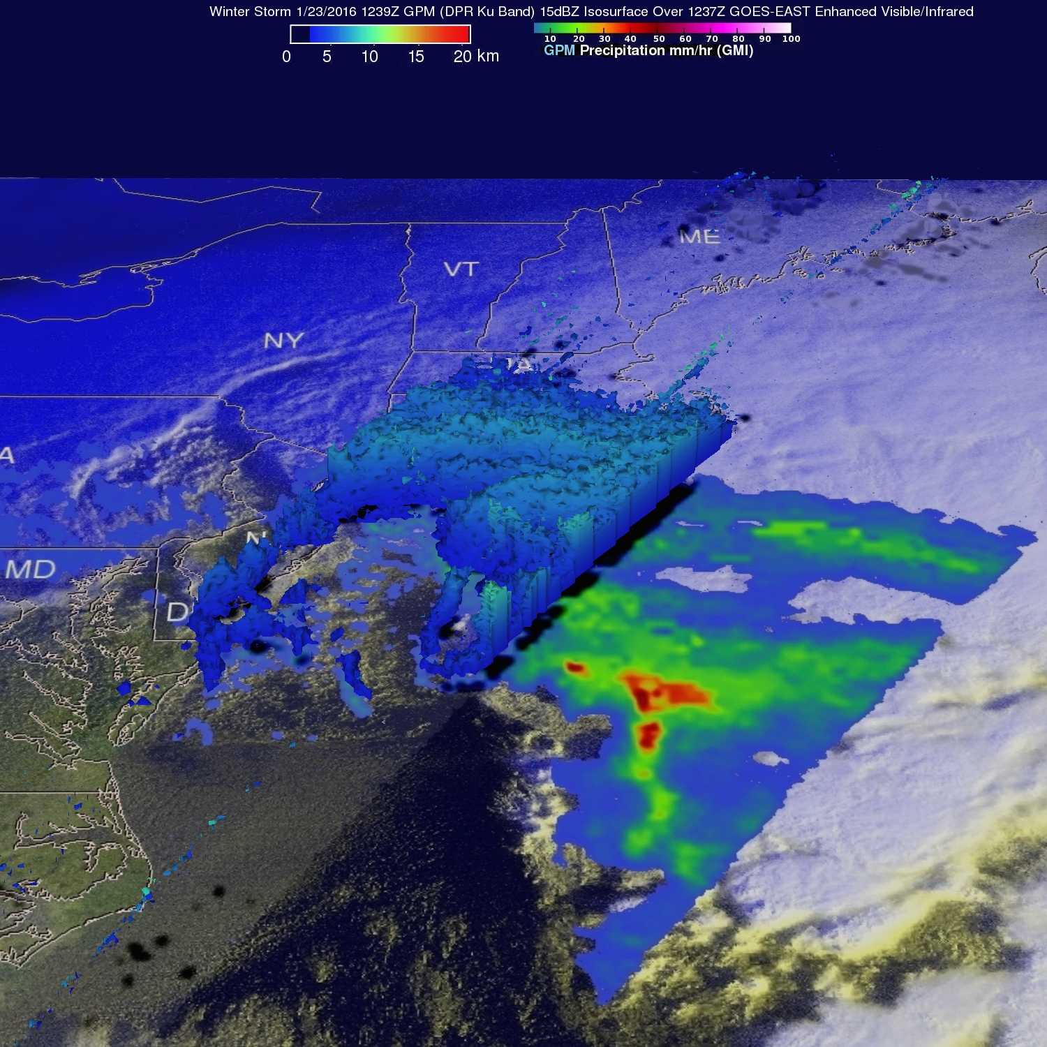
GPM's Radar instruments provided 3-D data (DPR Ku Band) showing the 3-D structure of rainfall within bands of precipitation in the winter storm.
Click here to see a 1280x720 a (Quicktime) 3-D Flyby animation.
Click here to see a 1280x720 (MPEG) 3-D Flyby animation.
UPDATE 1/22/2016 1:30pm ET
The winter storm that caused damage during the night along the Gulf Coast has deepened and has started to spread heavy rain, freezing rain, sleet and snow northward. The GPM core observatory satellite had another excellent early daylight view of the increasingly dangerous storm on January 22, 2016 at 1329 UTC (8:29 AM EST). A precipitation analysis is shown using data collected by GPM's Microwave Imager (GMI) and Dual-frequency Precipitation Radar (DPR) instruments. Precipitation was shown by DPR falling at a rate of over 64 mm (2.5 inches) per hour in storms over northern Alabama. Heavy snowfall and increasingly strong winds through Saturday are predicted to cause dangerous blizzard conditions in Washington, D.C.
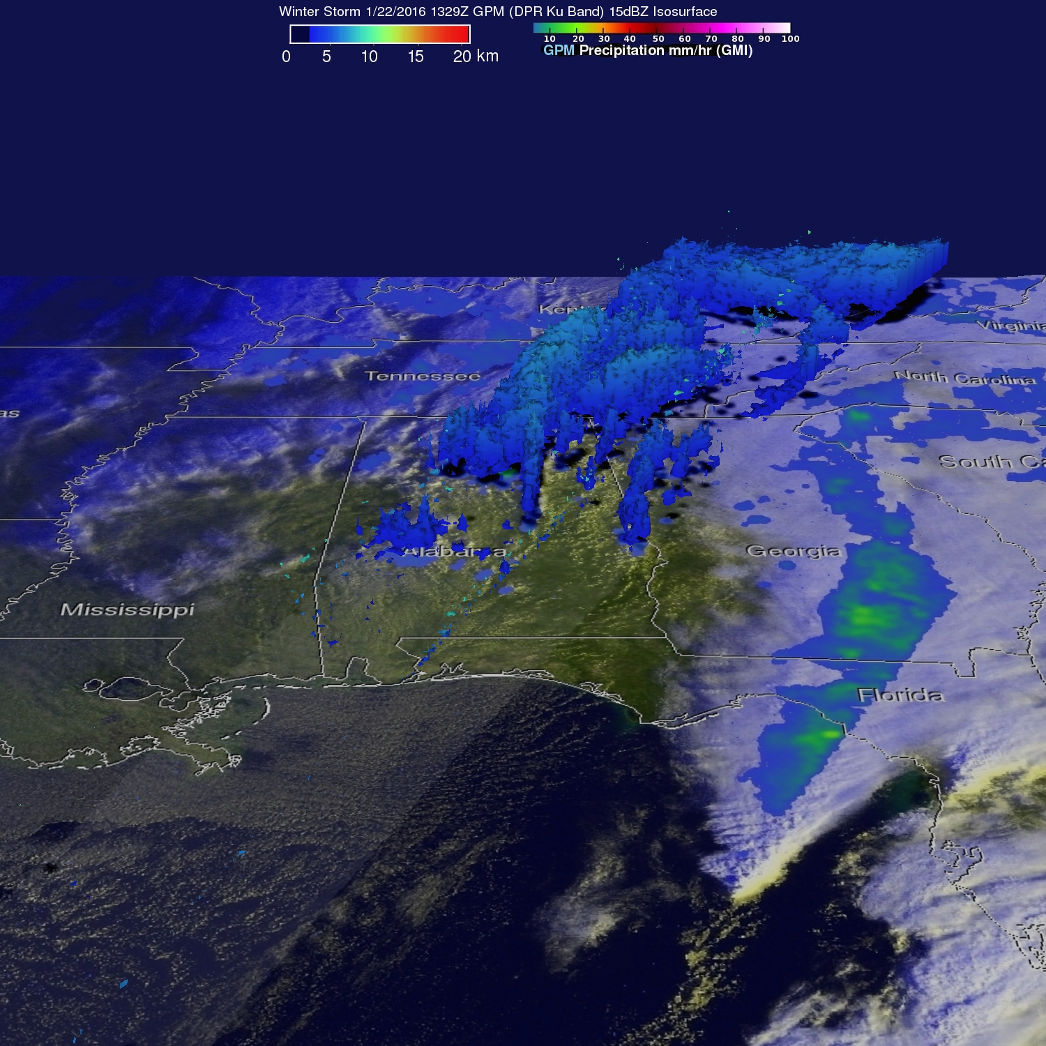
3-D radar data from GPM's DPR (Ku Band) show the vertical structure of storm tops in the winter storm.
UPDATE 1/22/2016 9:00am ET
An intensifying winter storm that is forecast to cause an historic blizzard in the Washington, D.C. area has also spawned severe weather in states from Texas to Florida along the Gulf Coast. NASA's Global Precipitation Measurement or GPM mission core satellite observed the extreme rainfall this system was generating in the Gulf coast.
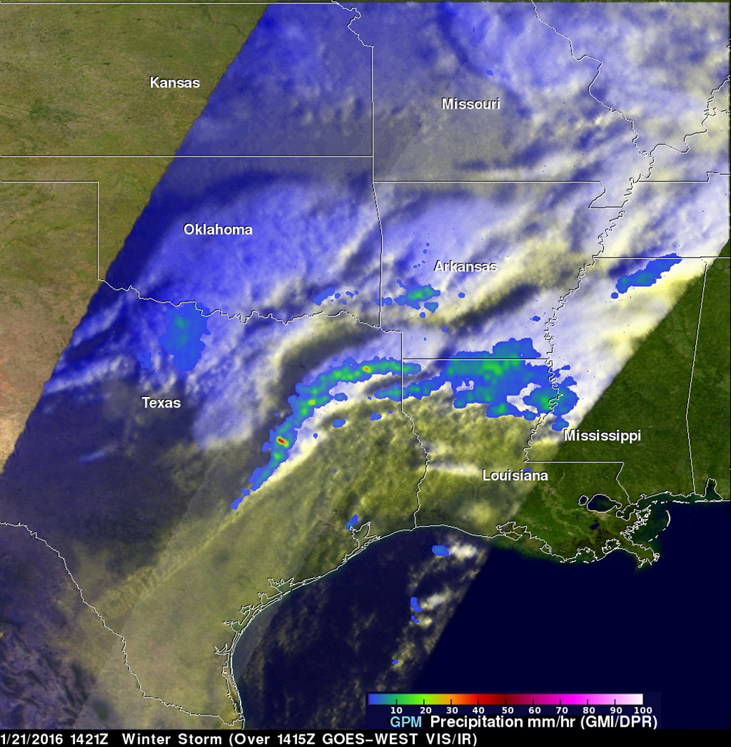
There were numerous reports of hail near this system from Thursday morning, Jan. 21 through early Friday morning, Jan. 22. At least one tornado was reported with this severe weather. The GPM core observatory satellite flew over the Gulf Coast on January 21, 2016 at 1421 UTC (8:21 a.m. CST) and had a good view of extreme rainfall occurring within this developing winter storm.
At NASA's Goddard Space Flight Center in Greenbelt, Maryland, data from GPM's Microwave Imager (GMI) and Dual-frequency Precipitation Radar (DPR) were used to measure the rainfall that was occurring when GPM traveled overhead from space. GPM's DPR observed rain falling at a rate of over 100 mm (3.9 inches) per hour in one line of storms moving over eastern Texas. GPM's 3-D radar data (Ku Band) were used to create a 3-D flyby of precipitation. GPM is a mission managed by both NASA and the Japan Aerospace Exploration Agency.
Behind the weather system, on Jan. 22, a tight pressure gradient will result in strong and gusty winds of 15 to 20 mph with gusts to 25 to 30 mph across south central and southwestern Arkansas, north central Louisiana, southeastern Oklahoma and northeastern Texas, according to the National Weather Service in Shreveport, Louisiana.
As the storm moves, east, places like eastern Arkansas are under winter storm warnings for ice accumulation. The National Weather Service in Little Rock Arkansas noted that much of central, southern and eastern Arkansas are facing additional ice accumulations of up to a tenth of an inch will be possible...with localized heavier amounts and additional snow and sleet. In addition, severe weather is also possible across eastern Gulf coasts and Florida.
On Jan. 22, the National Weather Service Weather Prediction Center in College Park, Maryland said "A potentially crippling winter storm is anticipated for portions of the mid-Atlantic Friday into early Saturday. Farther south, significant icing is likely for portions of Kentucky and North Carolina." For updates on the storm, visit: www.weather.gov.
Images and captions by Hal Pierce (SSAI / NASA GSFC)