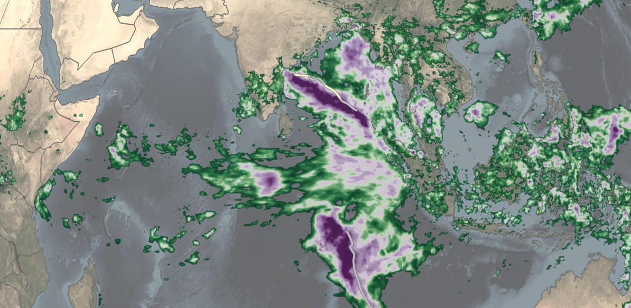
Twin Tropical Cyclones Form in the Indian Ocean
Over the past several days, a relatively rare event occurred in the eastern Indian Ocean: the formation of “twin” tropical cyclones. Tropical Cylones Karim and Asani formed at nearly the exact same time (06:00 UTC and 06:30 UTC, 12:00 pm and 12:30 pm local time) on May 7 on opposite sides of the Equator. Karim officially formed first in the southern hemisphere (SH) followed immediately by Asani in the northern hemisphere (NH). At first glance, the cyclones appear to be mirror images of one another with Asani rotating counterclockwise in the NH and Karim rotating clockwise in the SH roughly equidistant on opposite sides of the Equator. Tropical cyclones (known as tropical storms or hurricanes in the Atlantic and East Pacific) are areas of low pressure, which rotate in opposite directions on opposite sides of the Equator. Karim and Asani are “twin” cyclones not only because they formed at the same time in the same general area but also because they were formed primarily from the same “parent” circulation: the Madden-Julian Oscillation or MJO.
The MJO is an intraseasonal oscillation. Its time scale is on the order of 30 to 60 days; it is also known as the 30-to-60 day oscillation or wave. The MJO acts a little like El Niño or La Niña by concentrating tropical convection or thunderstorm activity but is smaller in scale and doesn’t remain stationary but propagates eastward. The MJO first emerges in the western Indian Ocean before propagating eastward across the eastern Indian Ocean, Maritime Continent and out into the West Pacific. The MJO provides an environment that is conducive to the birth of tropical cyclones. Tropical cyclones need active thunderstorms to drive their circulations. This is exactly what happens in the “enhanced” phase of the MJO. Tropical cyclones also need a source of spin. This can be provided by the Earth’s rotation, but the circulation pattern associated with the MJO can further assist be providing an environment with even more rotation. A prominent feature of the MJO is the westerly wind burst. In the Tropics, trade winds blow from the east, but on the backside of the MJO air is drawn inward at low levels. This leads to the development of low-level westerly winds along the Equator. When combined with easterly winds farther away on either side of the Equator, it produces a low-level environment with enhanced rotation. There are also other tropical waves or circulations that can interact with and influence the MJO, but the MJO tends to have the largest overall impact on the formation of “twin” tropical cyclones.
Download video (right-click -> "Save As")
The above animation shows surface rainfall estimates from NASA’s IMERG satellite precipitation product for the period May 4-11, 2022, in association with the evolution of the MJO and the formation of Tropical Cyclones Karim and Asani over the Indian Ocean. The animation shows instantaneous rain rates (in blue and yellow) overlaid on rainfall accumulations (shown in green and purple) and infrared (IR) cloud top data (shown in white). Storm tracks for Karim and Asani are based on data from the Joint Typhoon Warning Center (JTWC).
Initially, IMERG shows precipitation spread across the Equatorial Indian Ocean with the most rain occurring along the Equator in the western Indian Ocean. The pattern then quickly shifts with a much larger concentration of rainfall emerging over and around the Equator in the eastern Indian Ocean. This is associated with the intensification and propagation of the MJO from the western Indian Ocean (known as phase 1 of the MJO) into the eastern (known as phase 2). During the 2nd phase of the MJO, the precipitation pattern takes on an almost arrow shape with the arrow aligned along the Equator pointed at Sumatra. This feature is associated with the development of a westerly wind burst. Soon after, the pattern again evolves with rainfall tending to subdivide into two separate areas north and south of the Equator. These two areas of precipitation then begin to rotate before further developing into Tropical Cyclones Karim and Asani. Despite their similar origins, however, environmental conditions are different between the Northern and Southern Hemisphere. Karim has so far tracked almost due south and remained at tropical storm intensity. Karim is also forecast to remain well away from land for the next few days. Meanwhile, Asani has tracked steadily off to the northwest and oscillated between tropical storm and Category 1 (equivalent hurricane) intensity. It is also poised to make landfall along the east coast of India.
Learn more about the twin tropical cyclones at NASA's Earth Observatory
Credits:
Animation by Jason West (NASA GSFC / NASA PPS / Adnet)
Story by Stephen Lang (NASA GSFC / SSAI)

