Indian Ocean

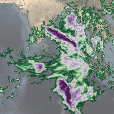
IMERG totals from twin cyclones in the Indian Ocean
Over the past several days, a relatively rare event occurred in the eastern Indian Ocean: the formation of “twin” tropical cyclones. Tropical Cylones Karim and Asani formed at nearly the exact same time (06:00 UTC and 06:30 UTC, 12:00 pm and 12:30 pm local time) on May 7 on opposite sides of the Equator. Karim officially formed first in the southern hemisphere (SH) followed immediately by Asani in the northern hemisphere (NH). At first glance, the cyclones appear to be mirror images of one another with Asani rotating counterclockwise in the NH and Karim rotating clockwise in the SH roughly

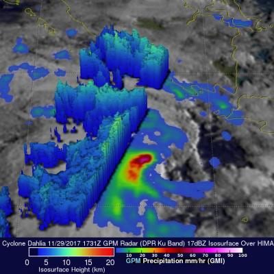
GPM Observes Tropical Cyclone Dahlia In Southwest Indian Ocean

Yesterday tropical Cyclone Dahlia became the first tropical cyclone of the 2017-2018 Southwest Indian Ocean season. Today, Dahlia was moving toward the southeast and was passing to the south of the Indonesian islands of Java and Sumatra with wind speeds of about 35 kts (40.3 mph). Tropical cyclone Dahlia was passing over the warm ocean waters (28-29 degrees Celsius) of the Indian Ocean. On November 29, 2017 at 1731 UTC NASA's GPM Core Observatory satellite passed above forming tropical cyclone Dahlia. Data collected by GPM's Microwave Imager (GMI) and Dual-Frequency Precipitation Radar (DPR)

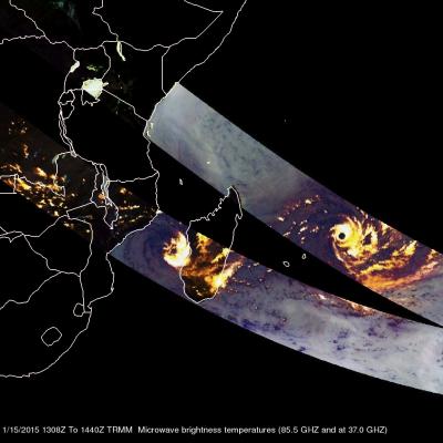
Southwest Indian Ocean Has Two Tropical Cyclones

As tropical storm Mekkhala approaches the Philippines in the northern hemisphere tropical cyclone activity in the southeast Indian ocean has recently increased. The TRMM satellite has been monitoring rainfall in the tropics since 1997. On February 15, 2015 the TRMM satellite flew over two tropical cyclones in successive orbits. BANSI 1/15/2015 1308Z CHEDZA 1/15/2015 1440Z Rainfall derived from TRMM's Microwave Imager (TMI) is shown overlaid on a METEOSAT-7 Visble/Infrared images. On January 15, 2015 at 1308 UTC the satellite saw powerful category four tropical cyclone Bansi northeast of the

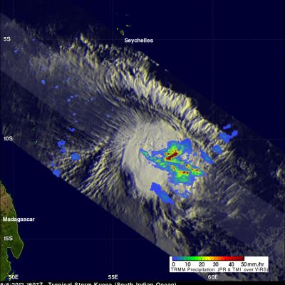
Late Season Tropical Storm Kuena Forms

A tropical storm called Kuena formed in the southwest Indian Ocean east of Madagascar on June 6, 2012. This is a little unusual because the tropical cyclone season in that area normally ends on May 15. The TRMM satellite had an excellent view of Kuena when it flew directly above the newly formed storm on June 6, 2012 at 1607 UTC. A rainfall analysis that used data from TRMM's Microwave Imager (TMI) and Precipitation Radar (PR) instruments is shown overlaid on an enhanced infrared image from TRMM's Visible and InfraRed Scanner (VIRS) instrument. This analysis shows that heavy convective storms