TRMM News

Short-Lived Tropical Storm Franklin

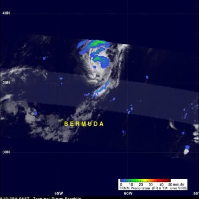
Tropical Storm Franklin was only active for a short time but the TRMM satellite had a fairly good view when it passed above on Saturday August 13 at 0115 UTC. TRMM's Microwave Imager (TMI data shows that Franklin was dropping some light to moderate rainfall north-northeast of Bermuda. Franklin became extra-tropical a little later as it moved into the open waters of the north Atlantic.

Tropical Storm Emily Rainfall

The TRMM-based, near-real time Multi-satellite Precipitation Analysis (TMPA) at the NASA Goddard Space Flight Center provides estimates of rainfall over the global Tropics. TMPA rainfall totals associated with tropical storm Emily are shown for the period from 1 to 8 August 2011. Approximate locations for Emily are shown with appropriate red symbols and the storm's 0000Z positions were labeled. The TMPA analysis above indicates that Emily dropped the heaviest rainfall totals of close to 300 mm (~11.8 inches) in the Caribbean Sea south of the Dominican Republic. Tropical storm Emily formed near

Tropical Storm Emily Weakens but May Revive

Tropical Storm Emily dissipated after being disrupted by the mountains of Hispaniola but according to the National Hurricane Center (NHC), may revive again within a couple days while moving toward the northwest. The TRMM rainfall analysis on the right, from a TRMM orbit on 4 August 2011 at 0934 UTC ( 5:34 AM EDT), shows that heavy rainfall was being produced by the dissipating storm over southern Haiti and the Dominican Republic at that time. See more news about Tropical Storm Emily

TRMM Sees Rainy Emily

The TRMM satellite saw tropical storm Emily again on 4 August 2011 at 0122 UTC (9:22 PM EDT). An analysis of TRMM's Microwave Imager (TMI) and Precipitation Radar (PR) data showed that Emily was dropping heavy rainfall of over 50mm/hr (~2 inches) south of the Dominican Republic and produce some showers in Haiti. Life threatening flooding and landslides are possible as Emily moves slowly westward.

Typhoon Muifa To Affect Okinawa

Typhoon Muifa had wind speeds of about 95 kts (~109 mph) when the TRMM satellite passed above on 3 August 2011 at 1307 UTC. Muifa is now predicted to pass just to the south of the Japanese Island of Okinawa. The southern tip of the Okinawa is expected to be in the right front quadrant of the typhoon on 5 August 2011 where the highest winds are normally located. TRMM's Microwave Imager (TMI) and Precipitation Radar (PR) data were used in the rainfall analysis shown on the right. See earlier TRMM information about typhoon Muifa.

Tropical Storm Emily Viewed by TRMM

The National Hurricane Center (NHC) announced the formation of tropical storm Emily on 1 August 2011 at 2330 UTC (7:30 PM AST). The TRMM satellite flew over the storm a short time later on 2 August 2011 at 0137 UTC (9:37 PM AST). A rainfall analysis from TRMM's Microwave (TMI) and Precipitation Radar (PR) data is shown above. This analysis shows that relatively little rainfall was occurring near the storm's approximate center that is indicated by a red tropical storm symbol. Moderate rainfall was revealed in a large feeder band on the eastern side of the storm. Emily is predicted to move

Typhoon Muifa Heading Toward Okinawa

MUIFA was a super typhoon with wind speeds of 140 kts (~161 mph) on 30 August but wind speeds had dropped to about 110 kts (~127 mph) when it was seen by the TRMM satellite on 1 August 2011 at 1320 UTC. This TRMM orbit revealed that MUIFA had a double eyewall indicating that the typhoon was undergoing eyewall replacement with a larger eyewall shown forming farther out from a smaller inner eyewall. Muifa is expected to still be a powerful typhoon on 4 August 2011 as it passes directly over the Japanese island of Okinawa.

TRMM Looks At Potential Atlantic Storm

On 1 August 2011 at 0056 UTC the TRMM satellite traveled above an area of low pressure east of the Lesser Antilles that the National Hurricane Center (NHC) has assigned a high probability (90%) of becoming an Atlantic tropical cyclone within the next few days. TRMM's Precipitation Radar (PR) saw a few tall convective thunderstorm towers within this area (see below image).