Extreme Weather

Typhoon Megi Hits Taiwan

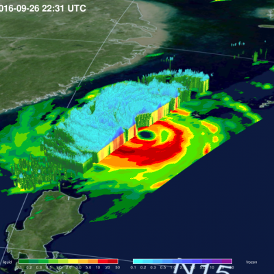
Three typhoons have battered Taiwan in the past few weeks. Super Typhoon MERANTI, the strongest typhoon of the year, caused havoc as it passed to the south of Taiwan on September 14, 2016. Typhoon Malakas clipped northeastern Taiwan a few days later. Typhoon Megi has now caused injuries, deaths and destruction as it passes over northeastern Taiwan. The GPM core observatory satellite passed over on September 26, 2016 at 2231 UTC when typhoon Megi was approaching Taiwan from the Philippine Sea. Megi was intensifying with maximum sustained wind speeds estimated at 100kts (115 mph). The typhoon's
Shelf cloud approaching the beach.
Thank you to everyone who submitted photos to the first installment of our GPM Extreme Weather Photo Competition. We loved all of your entries and thoroughly appreciate your participation! The GPM Photo Competition Committee is happy to announce our top 5 picks. We’ll be sending the submitters NASA bags and GPM stickers. Please stay tuned for additional contests and activities. Ormond Shelf, by Jason Weingart Date and Location: May 15, 2012 Ormond Beach, Florida How this Photo Was Taken: “I'm a photography student at the University of Central Florida. I began chasing storms a little over three...
GPM Extreme Weather Photo Contest
Powerful weather systems like thunderstorms and tornadoes are awesome displays of the force of nature. Now NASA wants to display YOUR photos of extreme weather! Post your coolest photographs and we'll pick the best ones to feature on the NASA Precipitation Measurement Missions websites (http://pmm.nasa.gov/ & http://www.nasa.gov/GPM). While we want extreme weather, we don't want YOU to be too extreme. So before you take that photo, please make sure you're keeping safe. Submission Guidelines: Submit your photo's to the GPM Extreme Weather Flickr group: http://www.flickr.com/groups/gpm-extreme...
Map of tracking hurricane Irene
This page will redirect you to the "GPM: Hurricanes Beyond the Tropics" video. Click here if you are not redirected.

GPM: Hurricanes Beyond the Tropics

Submitted by JacobAdmin on Tue, 08/28/2012
Video Embed

On August 28, 2011, Tropical Storm Irene hit Vermont, causing widespread damage and the worst flooding in 75 years. Irene's impact in New England shows that tropical cyclones can greatly affect regions outside the view of TRMM. The Global Precipitation Measurement (GPM) mission will build upon TRMM's legacy by examining a larger swath of Earth with more sensitive instruments.


Visualization of a Tropical Cyclone from above as it approaches Florida
Stormfront approaching the city of Bangalore, India Source: Manish Bansal Constantly scanning the Earth’s surface, the GPM Microwave Imager (GMI) allows scientists to both track tropical cyclones and forecast their progression. Used by NOAA’s National Hurricane Center (NHC), the Joint Typhoon Warning Center (JTWC), and tropical cyclone centers in Japan, India, Australia and other countries, detailed microwave information provides data on the location, pattern and intensity of rainfall. Tropical Cyclone Eunice in the South Indian Ocean on January 28, 2015. GPM's Microwave Imager (GMI) found...