eyewall

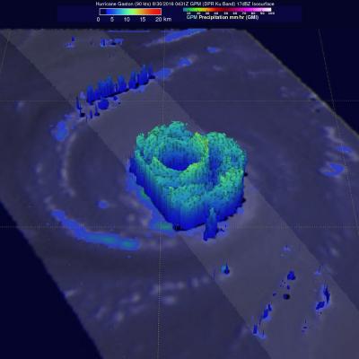
GPM Views "Truck-Tire" Eyewall of Typhoon Soulik

View Fullscreen in STORM Event Viewer Avoiding Kyushu, Typhoon Soulik instead barrelled toward the Northern Ryukyu islands, with the 'truck-tire' eyewall impacting Amami (in the south) and Yakushima (in the north) Islands in this overflight. It featured winds approaching 100 knots as it moved northwestward. Soulik is expected to recurve toward the western coast of Korea, where it is likely to have devastating impacts to the majority of the peninsula depending on its ability to maintain intensity.
Intense Hurricanes Seen From Space
In 2017, we have seen four Atlantic storms rapidly intensify with three of those storms - Hurricane Harvey, Irma and Maria - making landfall. When hurricanes intensify a large amount in a short period, scientists call this process rapid intensification. This is the hardest aspect of a storm to forecast and it can be most critical to people's lives. While any hurricane can threaten lives and cause damage with storm surges, floods, and extreme winds, a rapidly intensifying hurricane can greatly increase these risks while giving populations limited time to prepare and evacuate.
GPM Sees Hurricane Matthew Nearing Florida
UPDATE 10/6/16: NASA's Global Precipitation Measurement mission or GPM core observatory satellite flew over Hurricane Matthew several times as the category 4 storm headed toward Florida. The GPM Core Observatory carries two instruments that show the location and intensity of rain and snow, which defines a crucial part of the storm structure – and how it will behave. The GPM Microwave Imager sees through the tops of clouds to observe how much and where precipitation occurs, and the Dual-frequency Precipitation Radar observes precise details of precipitation in 3-dimensions. This data...

GPM Views Hurricane Gaston Eye Wall Replacement

Hurricane Gaston was located in the central Atlantic Ocean west of Bermuda when the GPM core observatory satellite passed over on August 30, 2016 at 00:31 AM EDT (0431 UTC). Gaston was a category two on the Saffir-Simpson hurricane wind scale with maximum sustained winds of about 103.5 mph (90 kts). GPM happened to fly over as Gaston was undergoing an eye wall replacement. Intense rainfall was clearly shown by GPM in rain bands of both the inner and the outer replacement eye walls. Precipitation was calculated from data collected by GPM's Microwave Imager (GMI) and Dual-Frequency Precipitation

GPM Looks Into Cyclone Joalane's Eye

Cyclone Joalane had developed a small clear eye when the GPM core observatory satellite passed above on April 7, 2015 at 1436 UTC. GPM's Microwave Imager (GMI) data showed that the heaviest rain was falling at a rate of over 78.6 mm (3 inches) per hour in a feeder band wrapping around Joalane's eastern side. This simulated 3-D flyby around Joalane was made using data from the Ku band on GPM's dual frequency radar. Those radar data discovered that the intense thunderstorms, reaching heights above 16 km (9.9 miles), were located where the heaviest rainfall was measured by GPM's GMI.

TRMM Satellite Makes Direct Pass over Super Typhoon Maysak

The Tropical Rainfall Measuring Mission satellite delivered a remarkable image of Super Typhoon Maysak on March 31. TRMM obtained an image straight over the top of a super typhoon with a double eye-wall, Super Typhoon Maysak, as it roared through the warm waters of the West Pacific south of Guam. This image with the TRMM Precipitation Radar or PR was taken at 14:15 UTC (10:15 a.m. EDT) on March 31, 2015 and shows the rain intensities within the very heart of Super Typhoon Maysak as it undergoes an eye wall replacement cycle. Mature, intense tropical cyclones can and often do undergo what is
GPM Uncovers Compact Eyewall in Hurricane Simon
Hurricane Simon appeared to be keeping a secret before it rapidly intensified on Oct. 4, but the Global Precipitation Measurement or GPM satellite was able uncover it. On Oct. 4 at 0940 UTC (5:40 a.m. EDT) observations by the Ku-band radar on the GPM satellite suggested that the Eastern Pacific Ocean's Hurricane Simon was hiding a very compact eyewall hours before the National Hurricane Center detected rapid intensification of Simon's surface winds. The GPM satellite was launched in February of this year and is managed by both NASA and the Japan Aerospace Exploration Agency. On Oct. 4 at 0940...

TRMM Sees Adrian's Eye

Hurricane Adrian's eye was clearly seen by the TRMM satellite when it passed over on 10 June 2011 at 1608 UTC. The heavy rainfall completely surrounding Adrian's well defined eye was revealed with TRMM Microwave Imager (TMI) data obtained at the same time. Hurricane Adrain, located southwest Mexico , was classified as a dangerous category 4 on the Saffir-Simpson scale with sustained wind speeds estimated at 115 kts (~132 mph).