Hagupit

Deadly Super Typhoon Hagupit Moved Slowly

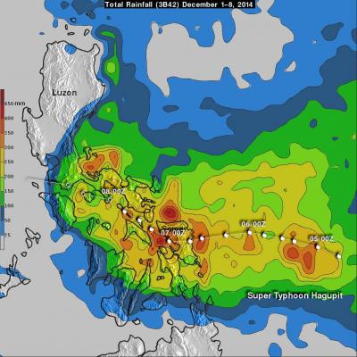
As of Today, super typhoon Hagupit has been deadly with up to 27 deaths reported but the Philippines has been spared the widespread destruction caused by Super typhoon Haiyan in 2013. Hagupit's (called Ruby in the Philippines) forward motion slowed on December 4, 2014 before reaching the Philippines. After hitting Samar in the eastern Philippines Hagupit's continued slow movement resulted in high rainfall amounts along the typhoon's track. These high rainfall totals meant that flooding occurred frequently along the typhoon's track. When the TRMM satellite flew over on December 8, 2014 at 0132

GPM Core Observatory Sees Hagupit's Eye

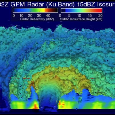
The GPM satellite flew almost directly above dangerous typhoon Hagupit on December 5, 2014 at 1032 UTC as the typhoon was approaching the Philippines. The GPM Microwave Imager (GMI) instrument measured rain falling at a rate of over 76 mm (almost 3 inches) per hour in the typhoon's eye wall. This 3-D view of Hagupit's precipitation structure was made using data from the Ku band on GPM's dual frequency radar instrument (DPR). DPR showed that some tall thunderstorm in Hagiput's eye wall were reaching heights of almost 15 km (about 9.3 miles). Click here to see a Low Resolution 640x360 simulated

Super Typhoon Hagupit Threatens Philippines

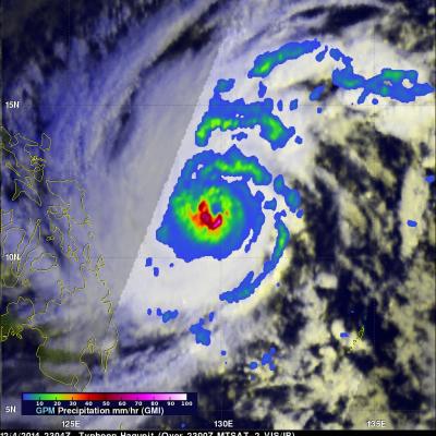
Super Typhoon Hagupit is threatening the Philippines a little over a year after deadly Super Typhoon Haiyan devastated the island nation in November 2013. Hagupit was weakening slightly from peak wind speeds of 155 kts (178 mph) when the GPM core observatory satellite passed over on December 4, 2014 at 2304 UTC in the image shown above. Hagupit had winds of about 125 kts (144 mph) when viewed by the TRMM satellite on December 5, 2014 at 0308 UTC in the image shown below. Rainfall data from these satellites are shown overlaid on daylight views from the MTSAT-2 satellite captured at close to the