heavy rain

<iframe width="490" height="276" src="https://www.youtube.com/embed/oiGzKmfOvkg?rel=0" frameborder="0" allowfullscreen></iframe>
As we enter the new year, take a look back at the snowstorms, tropical storms, typhoons, hurricanes and floods captured and analyzed by the Global Precipitation Measurement (GPM) mission from around the globe during 2015. The complete list of storms by date and location are as follows: 1. New England Nor’easter – January 26 – New England, USA 2. Snowstorm – February 17 – Kentucky, Virginia and North Carolina, USA 3. Tornadic Thunderstorms in Midwest – March 25 – Oklahoma and Arkansas, USA 4. Typhoon Maysak – March 30 – Yap Islands, Southwest Pacific Ocean 5. Rain Accumulation from Cyclone...

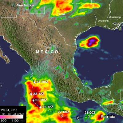
Cyclone Chapala Brings Heavy Rains, Flooding to Yemen

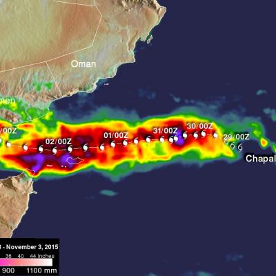
Cyclone Chapala, which formed into a rare but powerful Category 4 cyclone in the Arabian Sea with winds at one time estimated at 155 mph by the Joint Typhoon Warning Center (JTWC) back on the 30th of October, made its initial landfall along the south coast of Yemen this morning west of the port city of Mukulla at around 09:00 UTC as a Category 1 cyclone with maximum sustained winds estimated at 75 mph by JTWC, making it the first Category 1 cyclone on record to strike Yemen. The last cyclone to strike the Arabian peninsula was Cyclone Phet, which hit eastern Oman back in 2010. In addition to
Hurricane Patricia Makes Landfall in Mexico
The eye of hurricane Patricia hit the Mexican coast on October 23, 2015 at approximately 6:15 PM CDT(2315 UTC)near Cuixmala, Mexico. The maximum winds at that time were estimated to be 143 kts (165 mph). Patricia is weakening rapidly but continued heavy rain is expected to cause flash floods and mudslides in the Mexican states of Nayarit, Jalisco, Colima, Michoacan and Guerrero through Saturday October 24, 2015. Over the weekend the remants of Patricia are also expected to add to the extreme rainfall in Texas. Rainfall from a stalled front that has been causing flooding in northern and central...
NASA Aids Response to Carolina Flooding
It was rain that wouldn't quit. A weather system fueled by warm moisture streaming in from the Atlantic Ocean on Oct. 3 and 4 relentlessly dumped between one and two feet of rain across most of South Carolina. The result was rivers topping their banks and dams bursting. Catastrophic flooding followed across most of the state, which has left residents in some areas without power or clean drinking water. Tracking and predicting the deluge, both as rain and then floodwater, are the first steps to help protect people in harm's way. State and federal emergency managers have been on the front lines...

Tropical Storm Vamco Brings Rain To Southeast Asia

Tropical storm Vamco formed in the South China Sea on September 13, 2015 and went ashore in Vietnam a few days later. Although short lived Vamco dropped very heavy rainfall over the mountainous terrain of central Vietnam and in Laos and eastern Thailand. An Integrated Multi-satellite Retrievals for GPM (IMERG) rainfall analysis is shown here for the period from September 12-15, 2015. This analysis indicates that during this short period over 220 mm (8.7 inches) rain fell along the tropical storm's path. Flash floods and landslides were likely in areas where this drenching rainfall occurred.
Global Precipitation Measurement (GPM) Is In Position to Watch Effects of 2015’s El Niño
Since late in 2014, scientists in many different disciplines (including meteorologists, climate scientists, physical and biological oceanographers, hydrologists, and geologists) have been watching a slow-to-develop El Niño even in the tropical Pacific Ocean. After teasing observers with conditions that did not quite meet El Niño criteria 1 , the event finally reached official El Niño status in March and April, and is now expected to become a powerful event lasting into the next Northern Hemisphere winter. If these conditions, typified by warm sea surface temperatures (SST) in the tropical...

IMERG Sees Heavy Rain Over United States

During the past week the combination of tropical storm Bill's landfall and a slowly moving frontal system extending from the Midwest to the Northeastern states dropped extreme rainfall from Texas' Gulf coast to the northeastern states. Data from NASA's Integrated Multi-satellitE Retrievals for GPM (IMERG) were used in this analysis to estimate the extreme amount of rain that fell during the past seven days. Tropical Storm Bill and it's remnants caused very heavy rainfall while moving through Texas and Oklahoma. Over a foot of rain was reported in Oklahoma resulting in at least two deaths. The
GPM Sees Tropical Storm Bill Over Texas
Download in hi-res from the NASA Goddard Scientific Visualization Studio Tropical Storm Bill made landfall over Texas at approximately 11:45am CST on June 16, 2015. Shortly after midnight, GPM passed over the storm as it slowly worked it's way northward across the already drenched state of Texas. This visualization shows Bill at precisely 12:11:27am CST (6:11:27 GMT) on June 17, 2015. The GPM Core Observatory carries two instruments that show the location and intensity of rain and snow, which defines a crucial part of the storm structure – and how it will behave. The GPM Microwave Imager sees...

India's Monsoon Starts

Monsoon rainfall, although a little later than normal, has started in southern India. Due to El Nino conditions India's monsoon is predicted to bring below normal rainfall this year. Cooling rainfall comes to the country after high temperatures preceding the monsoon have caused the reported deaths of over 2300 people. Data from the NASA's Integrated Multi-satellitE Retrievals for GPM (IMERG) was used in this animation to show the advent of India's monsoon. Rainfall estimates for the past few days (4-5 June 2015) show that some heavy showers have dropped over 120mm (4.7 inches) of rain in the

Severe Flooding Hits Central Texas, Oklahoma

A stagnant upper-air pattern that spread numerous storms and heavy rains from central Texas up into Oklahoma has resulted in record flooding for parts of the Lone Star State. One of the hardest hit areas was in Hays County Texas south of Austin where the Blanco River rose rapidly and set a new record crest at over 40 feet, 13 feet above flood stage, following a night of very heavy rain in the area, with over 12 inches reported locally in a short period of time, in an area already wet from previous storms. The combination of high pressure over the southeastern United States and a persistent