Maria

Hurricane Maria Threatening The Leeward Islands

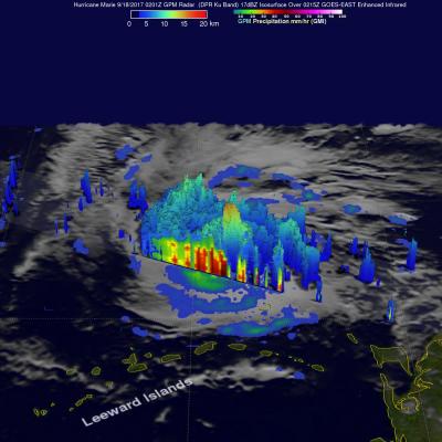
Intensifying hurricane Marie is on a path that is predicted to impact the Leeward Islands. Hurricane Irma caused death and wide spread destruction there less than two weeks ago. Very powerful convective storms and multiple lightning strokes within Maria have been cited as proof that Maria is an energetic intensifying hurricane. The GPM core observatory satellite had an excellent view of hurricane Maria when it passed almost directly above the hurricane on September 17, 2017 at 1001 PM AST (September 18, 2017 0201 UTC). GPM's Microwave Imager (GMI) and Dual-Frequency Precipitation Radar (DPR)

Maria Moving to the West of Bermuda

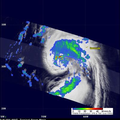
The TRMM satellite traveled above tropical storm Maria on Thursday 15 September 2011 at 1001 UTC ( 6:01 AM EDT). Maria's organization had improved over that seen by TRMM earlier in the week due to favorable (warmer) sea surface temperatures and lower upper level wind shear. A rainfall analysis from TRMM's Precipitation Radar (PR), displayed in a lighter swath, shows that powerful convective storms were dropping rainfall at a rate of over 50mm/hr (~2 inches) northwest of Maria's center of circulation. A large area of rainfall containing bands of heavier rainfall was also shown by TRMM's

TRMM Sees Disorganized Tropical Storm Maria

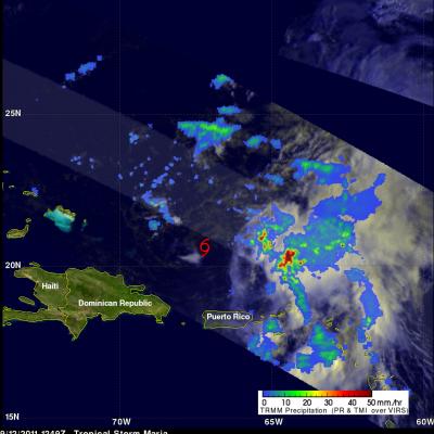
The TRMM satellite passed over tropical storm Maria on 12 September 2011 at 1249 UTC (8:49 AM EDT). This TRMM pass shows that tropical storm Maria's center of circulation was exposed and displaced well to the west of deep convection. A red tropical storm symbol was overlaid on the image derived from this TRMM pass to show the location of Maria's center of circulation. With this pass TRMM's Precipitation Radar (PR), shown in the lighter swath, scanned directly above the deep convection east of Maria's center. Those data showed that some rainfall in this area was very intense with rates of over