Nalgae

Tropical Storm Nalgae Weakens

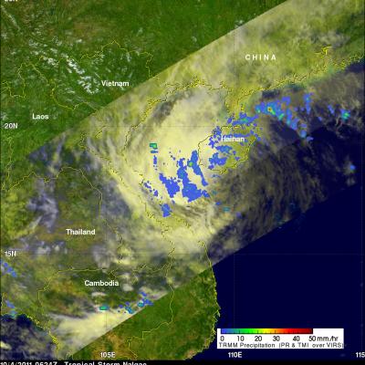
was a tropical storm and weakening rapidly when the TRMM satellite saw it on 4 October 2011 at 0624 UTC. This rainfall analysis from TRMM's Microwave Imager (TMI) and Precipitation Radar (PR) shows only scattered areas of light to moderate rainfall were present with Nalgae as it moved into the Gulf Of Tonkin west of Hainan. Click here to see earlier TRMM information about Nalgae.

Nalgae Exits The Philippines and Heads Toward China

The TRMM satellite had a good look at typhoon Nalgae on 2 October 2011 at 0637 UTC after it became the second typhoon in a week to hit the Philippines. Nalgae was in the middle of the South China Sea headed toward southern Hainan. In this image a rainfall analysis from TMI and PR data was overlaid on a combination Infrared and Visible image from TRMM's Visible and InfraRed Scanner (VIRS) instrument. See earlier information about Nalgae

Typhoon Nalgae Menaces the Philippines

The Philippines is still reeling from the devastation caused by typhoon Nesat as another typhoon called Nalgae approaches from the east. Nalgae formed on 27 October 2011 near the same area of the western Pacific Ocean where Nesat originated. The TRMM satellite had a daylight look at Nalgae (known as Quiel in the Philippines) on 30 September 2011 at 0653 UTC. TRMM's Microwave Imager (TMI) and Precipitation Radar (PR) data shows heavy rainfall near Nalgae's eye. The total area of rainfall isn't as extensive as it was with typhoon Nesat at this distance from the Philippines. Click here to see a