Prapiroon

GPM IMERG Analyzes Rainfall from Powerful Typhoon Prapiroon

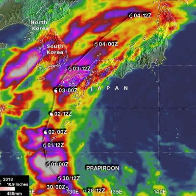
The image above shows estimates of accumulated rainfall using IMERG (Integrated Multi-satellitE Retrievals for GPM) data formed during the period from June 28-July 6, 2018. Typhoon PRAPIROON developed in the northwest pacific Ocean east-northeast of the Philippines on June 28, 2018. PRAPIROON became a typhoon on July 2nd as it approached the Korea Strait between Japan and Korea. Stormy weather had already produced heavy rainfall in Korea and Japan before typhoon PRAPIROON moved through the area. IMERG estimates indicated that PRAPIROON and other stormy weather dumped over 512 mm (20.2 inches)

Tropical Storm Prapiroon Probed By GPM Core Observatory Satellite

Tropical depression 09W was located in the northwest Pacific east of the Philippines when it was upgraded today to tropical storm PRAPIROON. The tropical storm is in a favorable environment for intensification. Vertical wind shear is low above the tropical cyclone and sea surface temperatures are warm below. NASA's GPM core observatory satellite had a good view of tropical storm PRAPIROON on June 29, 2018 at 0246 UTC. PRAPIROON was just barely a tropical storm with maximum sustained wind speeds estimated at about 35 kts (40.3 mph). GPM's Microwave Imager (GMI) and Dual-Frequency Precipitation

Weakening Typhoon Prapiroon

The TRMM satellite again flew above typhoon Prapiroon in the western Pacific Ocean on October 15, 2012 at 0632 UTC. Prapiroon's sustained wind speeds had dropped to 70 kts (~81 mph) with a large and ragged eye being it's dominant feature. TRMM's Microwave Imager (TMI) data indicated that the most intense rain bands south of Prapiroon's eye were dropping rain at a rate of about 30-40 mm/hr (~1.2 to 1.6 inches).

TRMM Sees Prapiroon Near Japan

The TRMM satellite recently had good views of tropical storm Prapiroon when it was passing east of Japan. The TRMM satellite captured data on October 18, 2012 at 0845UTC and again at 1019 UTC. TRMM's Microwave Imager (TMI) and Precipitation Radar (PR) data show that rain associated with Prapiroon was falling at a rate of over 75mm/hr (~3 inches) in a feeder band northwest of the center of circulation. TRMM PR found radar reflectivity values above 50.770 dBz in that area. Some of the rainfall over Japan was being caused by a frontal system that was interacting with tropical storm Prapiroon