Puerto Rico

GPM IMERG Measures Rainfall Accumulation from Hurricane Dorian in the Caribbean

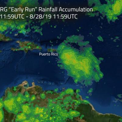
Hurricane Dorian is packing heavy rain as it moves toward the Bahamas as predicted by NOAA’s NHC or National Hurricane Center. NASA's GPM mission recently analyzed the storm and found heavy rainfall in the storm as it passed through the Caribbean. This image shows estimated rainfall accumulations for the region affected by Hurricane Dorian over the 24 hour period of Aug.27 11:59 UTC to Aug. 28 11:59 UTC. The imagery was generated using the Integrated Multi-satEllite Retrievals for GPM (IMERG) “early run” product. The data indicates that up to 120 mm (4.72 inches) of rainfall accumulated in

Hurricane Maria's Torrential Rainfall Measured By IMERG

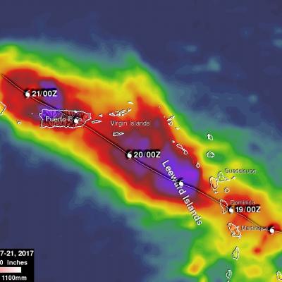
Hurricane Maria has caused catastrophic flooding in Puerto Rico. Extreme flooding was reported in the streets of San Juan, the capital of Puerto Rico. The National Weather Service issued flash flood warnings for the entire island. Hurricane Maria has now moved to the northwest of Puerto Rico but is still expected to contribute to rainfall over the island on Friday. Feeder bands are transporting rain over Puerto Rico and the Dominican Republic even as the hurricane moves toward the Turks and Caicos islands. NASA's Integrated Multi-satellitE Retrievals for GPM (IMERG) data were used to estimate

GPM Satellite Looks At Hurricane Maria's Rainfall

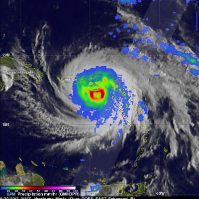
Early this morning (after 6 AM local time) hurricane Maria made landfall near Yabucoa, Puerto Rico as a strong category four hurricane. Maximum sustained winds in the hurricane were reported to be 149.5 mph (130 kts) as Maria moved toward San Juan, Puerto Rico. Powerful convective storms within the hurricane were also dropping heavy rainfall. The GPM core observatory satellite collected data as it passed above hurricane Maria earlier on September 19, 2017 at 9:51 PM AST (September 20, 2017 0151 UTC). This rainfall analysis was derived from GPM's Microwave Imager (GMI) and Dual-Frequency
TRMM Gets a Look at Irene, the First Hurricane of the Atlantic Season JacobAdmin Mon, 08/22/2011
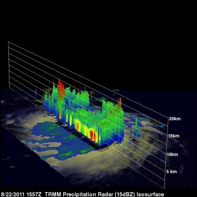
It's been a busy season so far in terms of tropical storms with seven named storms already in the Atlantic basin; however, none of them have had a very large impact as they have either been small, short-lived or remained at sea and none of them have intensified into a hurricane until now. Irene, which originated from a tropical wave that propagated off the west coast of Africa, became the 8th named storm of the season as it approached the Lesser Antilles on the 20th of August and the first hurricane of the season as it was passing over Puerto Rico on the morning of the 22nd. Now back over open