Roke

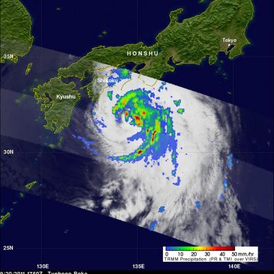
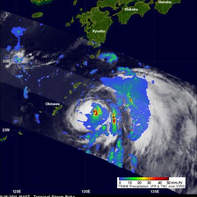
Typhoon Roke Brings Heavy Rains to Japan

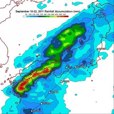
Typhoon Roke, which made landfall as a Category 1 typhoon along the southeast coast of Honshu near the city of Hamamatsu (about 200 km southwest of Tokyo), was responsible for bringing heavy rains and flooding to most of Japan. Heavy rains actually began effecting parts of southern Japan well before the cyclone neared the coast as tropical moisture from Roke streamed northward into a stalled out frontal boundary that was draped across southern Japan. Japan is also very mountainous, which can enhance the effect. The Tropical Rainfall Measuring Mission or TRMM satellite is used to measure

Typhoon Roke makes Landfall in Central Japan

Roke, a once powerful Category 4 typhoon with sustained winds estimated at 115 knots (~132 mph), came ashore in central Japan Wednesday around 2 pm local time near Hamamatsu on the southeast coast of Honshu (about 200 km southwest of Tokyo) as a Category 1 typhoon. Roke began as a tropical depression ten days ago in the central Philippine Sea about 850 miles (~1370 km) south of Japan. For over a week, the cyclone meandered south of Japan with little change in intensity. Roke finally began to intensify on the 19th of September when it became a typhoon just east of the Ryukyu Islands and then

Two Tropical Cyclones Near Japan

The TRMM satellite flew over two tropical cyclones near Japan on 18 September 2011. Typhoon Sonca, shown above, was seen off the east coast of the main Japanese island of Honshu at 1805 UTC while moving away from Japan toward the north-east. Sonca was still a powerful typhoon with wind speeds of about 85 knots (~98 mph) at that time but Sonca weakened to a tropical storm on 19 September 2011 while moving over the colder waters of the northern Pacific Ocean to the north-east of Japan. TRMM saw tropical storm Roke a little later at 1840 UTC. TRMM Precipitation Radar (PR) data shows that Roke