Sandra

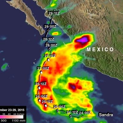
NASA IMERG Data Measures Hurricane Sandra's Rainfall

Data from NASA's Integrated Multi-satellitE Retrievals for GPM (IMERG) were used to estimate the amount of rainfall that hurricane Sandra produced during the period from November 23-29, 2015. Sandra remained well off the Mexican coast during the most dangerous period from November 25-27, 2015 when Sandra was a powerful hurricane with sustained winds of up to 130 kts (150 mph). This analysis shows that much of Sandra's rainfall occurred over the open waters of the Eastern Pacific. This analysis indicates that moisture flowing from hurricane Sandra also caused heavy rainfall totals of over 700

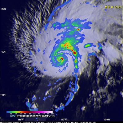
Powerful Hurricane Sandra Viewed By GPM

The GPM core observatory satellite flew above hurricane Sandra on November 26, 2015 at 0706 UTC. Sandra had winds of 125 kts (144 mph) at that time making it a category three on the Saffir-Simpson hurricane wind scale. This means that Sandra is the latest major hurricane ever recorded in the eastern Pacific Ocean. Numerous powerful hurricanes were predicted in the eastern Pacific Ocean at the beginning of the hurricane season due to the development of the 2015 El Nino. Data captured by GPM's Microwave Imager (GMI) and Dual-Frequency Precipitation Radar (DPR) instruments shows rain falling at a

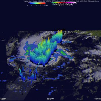
Tropical Storm Sandra

Early this morning tropical Storm Sandra became the 18th named storm of the 2015 Eastern Pacific hurricane season. Intensifying tropical storm Sandra had winds of about 35 kts (40 mph) when the GPM core observatory satellite passed over on November 24, 2015 at 0719 UTC. A rainfall analysis derived using data collected at that time by from GPM's Microwave Imager (GMI) and Dual-Frequency Precipitation Radar (DPR) instruments is shown. DPR discovered that the intense convective storms south of the tropical storm's center of circulation were dropping rain at a rate of over 80 mm (3.1 inches) per

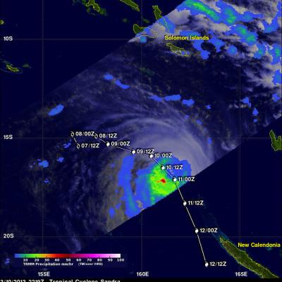
Tropical Cyclone Sandra Nearing New Caledonia

Tropical cyclone Sandra formed in the Coral Sea south off the Solomon Islands on March 7, 2013. Sandra intensified over the open waters of the Coral Sea and became a very powerful tropical cyclone with winds of about 110 kts (~127 mph). Sandra has started weakening but is predicted to buffet northern New Caledonia with tropical storm force winds on March 12, 2013. Sandra's approximate past and forecast locations are shown overlaid in white. The TRMM satellite passed above Sandra on March 10, 2013 at 2219 UTC. A rainfall analysis using data captured by TRMM's Microwave Imager (TMI) instrument

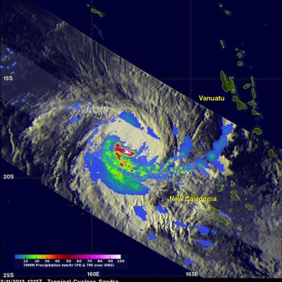
Tropical Cyclone Sandra Brushing New Caledonia

On March 11, 2013 the TRMM satellite twice flew above weakening tropical cyclone Sandra as it was passing to the west of New Caledonia in the southern Pacific Ocean. TRMM's Precipitation Radar (PR) had a very good view of Sandra as it passed directly above the tropical cyclone on March 11, 2013 at 1312 UTC. TRMM PR measured rainfall at the extreme rate of over 206 mm/hr (~8 inches) in an area southwest of Sandra's eye. Those TRMM PR data also showed that very little rain was occurring north of the weakening tropical cyclone's eye. Click here to see a simulated Flyby over Sandra using 3-D TRMM