tropical depression

GPM Sees the Formation of Early Atlantic Ocean Tropical Depression 1

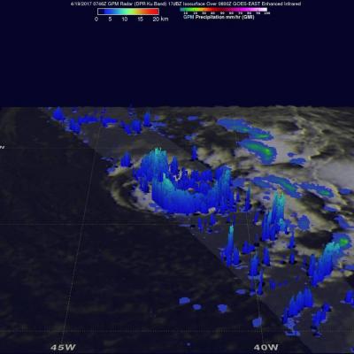
A low pressure area in the Atlantic Ocean, located southwest of the Azores was designated as Subtropical Depression One on April 19 as NASA examined its rainfall. By April 20 it had become the Atlantic's first tropical depression. Just as the subtropical depression was forming in the North Atlantic Ocean on April 19 at 11 a.m. EDT (1500 UTC) the Global Precipitation Measurement Mission or GPM core observatory satellite flew directly over it and identified areas where rainfall was heaviest in the system. Data collected by GPM's Microwave Imager (GMI) and Dual-Frequency Precipitation Radar (DPR)

Tropical Depression 08L Forms In The Caribbean

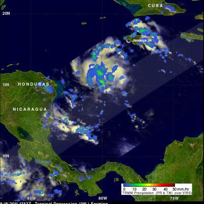
The TRMM satellite had a good daytime view of the tropical wave that was upgraded to the Atlantic Ocean basin's eighth tropical depression on 19 August 2011 at 0300 UTC (18 August 11 PM EDT). An image from TRMM's pass on 18 August 2011 at 1757 UTC (1:37 PM EDT) is displayed above and reveals that the precipitation pattern was getting a little better organized but heavy rainfall didn't cover a large portion of 08L at that time. Tropical depression 08L is predicted by the National Hurricane Center (NHC) to weaken to a remnant low in the next three days while producing rain over Honduras

Tropical Depression Three Intensifying

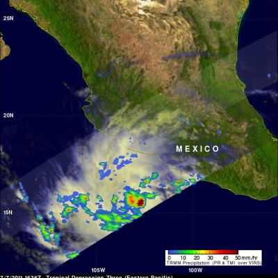
Tropical depression Three was showing much better organization with more heavy rainfall when the TRMM satellite saw it again on 7 July 2011 at 1636 UTC. Data from TRMM's Microwave Imager (TMI) showed that heavy rainfall was present in a large area over the center of the intensifying depression and in a feeder band to the west of the center. There were also a few showers shown along the Mexican coast to the northwest of the storm.

TRMM Sees Tropical Depression Forming

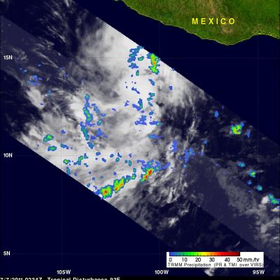
The TRMM satellite passed over an area of low pressure in the eastern Pacific Ocean south of Mexico on 7 July 2011 at 0234 UTC. The National Hurricane Center (NHC) in Miami, Florida upgraded this area of low pressure to a tropical depression at 1500 UTC ( 08:00 AM PDT) making it the third tropical depression in the eastern Pacific this hurricane season. Conditions are expected to be favorable for the depression to become a tropical storm within the next couple days. The rainfall analysis from TRMM's Microwave Imager (TMI) and Precipitation Radar (PR) data was overlaid on an infrared image from

First 2011 East Pacific Tropical Depression (ONE-E)

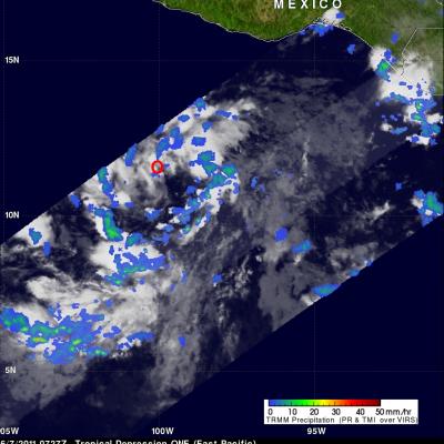
As predicted ONE-E, the first tropical depression of 2011, formed in the eastern Pacific Ocean early this morning. The image above used data that the TRMM satellite received when it flew over at 0727 UTC on 7 June 2011. A red circle shows the location of ONE-E's center of circulation at that time. ONE-E is expected to intensify and become tropical storm Adrian tomorrow.