Usagi

NASA's IMERG Used To Analyze Tropical Storm Usagi's Rainfall

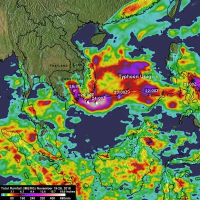
Usagi strengthened to hurricane intensity as it approached Vietnam from the South China Sea but weakened to tropical storm intensity when coming ashore. Very heavy rainfall and damaging winds accompanied tropical storm Usagi when it hit Vietnam's southern coast. More than 350 mm (14 inches) of rainfall was reported causing widespread flooding around Ho Chi Minh City. NASA's Integrated Multi-satellitE Retrievals for GPM (IMERG) data were used to show estimates of rainfall accumulation produced by Usagi as the tropical cyclone moved across the South China Sea into Southeast Asia. This IMERG

Deadly Typhoon Usagi Hits Southern China

The most powerful typhoon of 2013 hit southern China with reported winds of 95.6 kts (~110 mph) killing at least 20 people. The TRMM satellite had a fairly good view on September 22, 2013 at 0923 UTC as typhoon USAGI's eye was very near the coast of southern China. TRMM's Microwave Imager (TMI) and Precipitation Radar (PR) instruments showed that in addition to the extreme winds reported there were areas just south of USAGI's eye where rain was falling at a rate of over 169mm/hr (~6.7 inches). TRMM sliced through USAGI and found that heights of storms within USAGI were reaching only about 12km

Typhoon Usagi Still Powerful

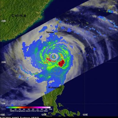
The TRMM satellite again flew directly above category two typhoon USAGI, with maximum wind speeds of about 120kts (~130mph), on September 21, 2013 at 0209 UTC as USAGI was passing between Taiwan and the Philippines. Rainfall data from TRMM's Microwave Imager (TMI) and Precipitation Radar (PR) instruments are shown in this image. TRMM PR found rain falling at a rate of over 134 mm/hr (~5.2 inches) in USAGI's eye wall where radar reflectivity values of over 51dBZ were returned to the satellite. A weaker Typhoon USAGI is predicted to hit Hong Kong tomorrow with wind speeds of 80kts (~92 mph).

Super Typhoon Usagi Threatens The Philippines and Taiwan

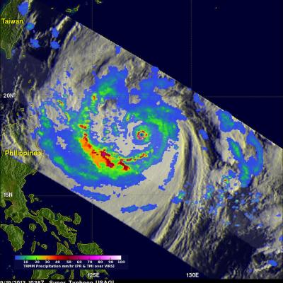
The most powerful typhoon of 2013 may affect the northern Philippines and southern Taiwan. What is now super typhoon USAGI formed in the open waters of the Philippine Sea about 1,000 km (~620 miles) east of the Philippines on September 16, 2013. USAGI rapidly intensified and became a typhoon yesterday. Super Typhoon USAGI had estimated maximum winds of close to 140kts (~161 mph) when the TRMM satellite had an excellent view on September 19, 2013 at 1035 UTC. A precipitation analysis from TRMM's Microwave Imager (TMI) and Precipitation Radar (PR) instruments is shown on the left overlaid on an