Data Access

Data Access content

Typhoon Dolphin Brushes Guam

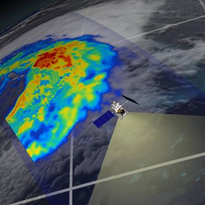
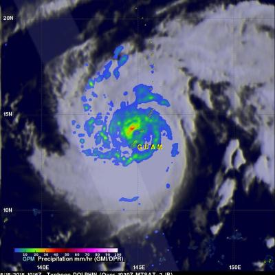
Typhoon Dolphin passed through the Northern Marianas today just to the north of Guam with sustained winds estimated at 95 knots (~109 mph) by the Joint Typhoon Warning Center. The center passed through the Rota Channel less than about 25 iles from the northern tip of Guam, close enough for the southern half of the eye wall to rake the northern part of the island with powerful winds. A wind gust of 106 mph was reported at Andersen Air Force Base located on the northeast corner of Guam. NASA's GPM Core observatory satellite captured this image of Dolphin just as the center was exiting the Rota

Recent 3B41RT and 3B42RT Files Reprocessed

NOAA has reprocessed the global IR data for 10 UTC 26 April through 14 UTC 27 April due to dropped images, and all 3B41RT and 3B42RT files for this time period have been reprocessed by PPS and are now available: 3B41RT.2015042610.7.bin.gz through 3B41RT.2015042714.7.bin.gz 3B42RT.2015042612.7.bin.gz through 3B42RT.2015042715.7.bin.gz Such partial dropouts in the IR data result in somewhat lower quality for IMERG Early and Late Runs, but are not cause for reprocessing.

Scheduled NASA Network Outage Sunday 4/26/15

On Sunday, April 26, 2015, between the hours of 12 noon (17 UTC) and 12 midnight EDT (05 UTC April 27) , changes will be implemented to NASA’s Internet access. The purpose of this outage is to complete the Corporate Route Symmetry Project which is being implemented by the Communications Services Office (CSO). As a result of these changes, users can expect an outage to the below services during this time period. Services Affected: On Sunday, April 26, 2015, changes to NASA’s Internet Access will have the following impacts: Internet access to/from all NASA networks External Virtual Private

IMERG Data Temporarily Suspended

Due to an outage of the input 4-km IR data, the IMERG early and late runs began failing to execute on the April 14. Because of the loss of NOAA hourly IR data, PPS has had to shut off the production of NRT early and late IMERG production. We have received no valid IR data since April 14 17:00 UTC and no IR data at all since April 15 09:00 UTC. The software is able to deal with bad data by skipping it but it is currently not configured to handle the situation of not receiving any data at all. We have received information that there are product problems at NOAA but have not received any

IMERG Data Now in Giovanni-4

The NASA Goddard Earth Sciences Data and Information Services Center (GES DISC) has recently added all of the half-hourly and monthly *Final* IMERG data variables to the next generation of Giovanni, Giovanni-4 (G4). Giovanni is a Web-based application developed by the GES DISC that provides a simple and intuitive way for users to visualize, analyze, and access vast amounts of Earth science remote sensing data, without having to download the data. Learn more: http://disc.sci.gsfc.nasa.gov/gesNews/imerg_in_G4

TRMM PR Data Distribution Resumes

TRMM/PR data distribution resumes during the experimental operation period. The satellite has descended to an altitude of around 350 km on February 12, 2015, which is the original nominal altitude before 2001. Verification of the data quality concluded and JAXA and PPS started distribution of PR data around the 350 km altitude (orbit number from 98231) to the public. PR available data period around 350 km altitude will be about 40 days since February 12, 2015. Please see TRMM/PR data distribution for further information and for the data locations.

Initial IMERG Products Released

PPS is re-releasing the first public version IMERG products The Integrated Multi-satellitE Retrievals for GPM (IMERG) merges precipitation estimates from passive microwave sensors, geo-IR, and monthly surface precipitation gauge analysis data (where available) to provide half-hourly and monthly precipitation estimates and related fields on a 0.1° lat./long. grid over the domain 60°N-S. The current period of record is mid-March 2014 to the present (delayed by about 3 months) .Please refer to the IMERG Release notes , the technical IMERG document and the IMERG Algorithm Theoretical Basis

GMI Production Halted for Deep Space Calibration

On December 8, 2014 and December 10, 2014 the GPM MOC will conduct deep space calibrations maneuvers that will assist in physically verifying GMI calibration changes and also help in further characterization of the GMI instrument itself. Special processing is required for the data collected during the DSC. Therefore, PPS production of Standard GMI products will be halted on Dec 8 at 20:30 UTC. Processing will resume during normal business hours on Dec 9. On December 10, the maneuver is scheduled to begin at 12:00 UTC. Depending on the arrival of the DSC data processing may again be halted

NOAA Network Restored

The NOAA network is gradually being restored. MHS data appears to have started flowing around 02:00 UTC on 23 October 2014, but as of 08:00 UTC on 23 October 2014 the Meteosat geo-IR data was still missing. As a result, users should see reduced areas of "missing" and higher-quality estimates in general starting with the 03:00 UTC 23 October 2014 3B42RT.

3B4xRT Reduced Volume of Data

Starting about 22:00 UTC on 20 October 2014 PPS started having issues with missing input data files originating at NOAA. Informally we have been told that there is a major network issue, but have no insight on its nature or likely duration. Until this is resolved, the input data for the 3B4xRT suite of products will suffer greatly reduced volume. Currently, we are not receiving sounder data, and the IR fields only have GOES-E and -W.