Resources

Resources content

NASA satellites used to predict zebra migrations
Of stars and stripes: NASA satellites used to predict zebra migrations One of the world's longest migrations of zebras occurs in the African nation of Botswana, but predicting when and where zebras will move has not been possible until now. Using NASA rain and vegetation data, researchers can track when and where arid lands begin to green, and for the first time anticipate if zebras will make the trek or, if the animals find poor conditions en route, understand why they will turn back. Covering an area of approximately 8,500 square miles (22,000 square kilometers), Botswana’s Okavango Delta is...
PMM Article Image
On a Wednesday afternoon in June, a severe storm outbreak spawned huge thunderstorms across Iowa and western Illinois. NASA's Polarimetric precipitation radar was in place to scan the storms as they swept through the region. "It's unbelievable out here," Walt Petersen of NASA's Wallops Flight Facility in Virginia wrote in an email dispatch from Traer, Iowa. There, two NASA radars were stationed as part of the Iowa Flood Studies field campaign, which Petersen led, for the Global Precipitation Measurement, or GPM, mission. Caption: A cluster of rain gauges and soil moisture sensors deployed in...
GPM Solar Array Deployment Test
By Kasha Patel, NASA Goddard Space Flight Center Original 
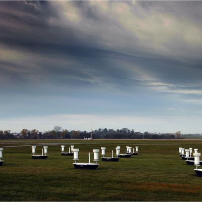
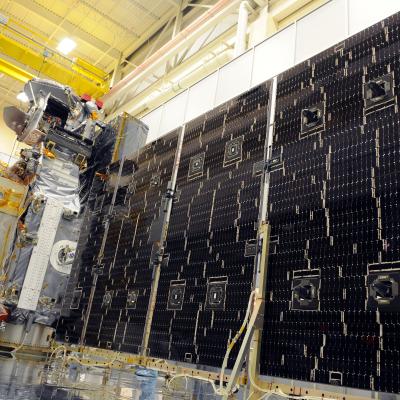
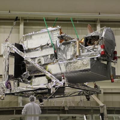
www.nasa.gov Feature (published 7/1/13) NASA successfully completed two pre-vibration solar array deployment tests of the Global Precipitation Measurement satellite on June 6 and June 15, 2013. This video montage shows scenes from the test deployments of both GPM Core satellite solar arrays in a clean room at NASA's Goddard Space Flight Center in Greenbelt, Md., in June 2013. Video Credit: NASA Goddard “Cross your fingers. Cross your toes,” said Art Azarbarzin, GPM project manager, as he watched engineers take their places around the...
IFloodS Observes Severe Storm Outbreak
Development of low storm clouds in the atmospheric mixing layer over the NPOL and D3R radars on June 12, 2013 at ~12:00 p.m. CDT. Credit: Walt Petersen /NASA . On Wednesday afternoon, June 12, a severe storm outbreak developed and moved across central and eastern Iowa, and then western Illinois, spawning huge thunderstorms and several tornadoes. NASA's Polarimetric (NPOL) precipitation radar, currently deployed in Iowa as part of the Iowa Flood Studies field campaign for the Global Precipitation Measurement mission, rapidly scanned these storms as they moved across the state. NPOL capturing...
PMM Article iFloods Banner
By Ellen Gray, NASA Goddard Space Flight Center Original www.nasa.gov Feature (published 4/30/13) Ground data now being collected in northeastern Iowa by the Iowa Flood Studies experiment will evaluate how well NASA's Global Precipitation Measurement (GPM) mission satellite rainfall data can be used for flood forecasting. GPM is an international satellite mission that will set a new standard for precipitation measurements from space, providing worldwide estimates of precipitation approximately every three hours. The GPM Core Observatory, provided by NASA and mission partner the Japan Aerospace...
NASA SOcial GPM banner
Join 60 of NASA's social media followers on Friday, April 12 at NASA's Goddard Space Flight Center in Greenbelt, Md., to learn about the many missions and partnerships between NASA and the Japan Aerospace Exploration Agency (JAXA). Held on the Friday before a weekend of events at the National Cherry Blossom Festival in Washington, D.C., the day-long NASA Goddard event is designed to be a celebration of the many successful and ongoing missions between NASA and JAXA. *** NASA Social participants and their friends and families may also want to attend the National Cherry Blossom Festival Parade...
White Silence by Gabor Dvornak
This page will automatically redirect you to the GPM "Let it Snow" photo contest winners. If you are not redirected, click here
Core Observatory Enters TVAC Chamber
This page will redirect you to the "GPM TVAC Video" video. Click here if you are not redirected.
Aerial photo of 2010 landslide in Gansu, China
By Lisa-Natalie Anjozian , NASA Goddard Space Flight Center Original www.nasa.gov Press Release (published 11/27/12) A NASA study using TRMM satellite data revealed that the year 2010 was a particularly bad year for landslides around the world. Around midnight on August 8, 2010, a violent surge of loosened earth roared down mountain slopes and slammed into quietly sleeping neighborhoods in Zhouqu County in Gansu, China. The catastrophic mudslides—the deadliest in decades according to state media—buried some areas under as much as 23 feet (7 meters) of suffocating sludge. 1,765 people died...
TRMM reign of rain screenshot
By Ellen Gray , NASA Goddard Space Flight Center Original www.nasa.gov Article (published 11/27/12) When it rains it pours, goes the saying, and for the last 15 years, the data on tropical rainfall have poured in. NASA's Tropical Rainfall Measuring Mission (TRMM) was launched on Nov. 27, 1997, and for the last decade and a half has enabled precipitation science that has had far reaching applications across the globe. TRMM Project Scientist Scott Braun looks back at the legacy of the Tropical Rainfall Measuring Mission and a few of the major scientific milestones the satellite has helped...