Science

Science content

GPM flying over Earth with a data swath visualized.
The NASA NPOL radar is a research grade S-band, scanning dual-polarimetric radar. The NPOL underwent a complete antenna system upgrade in 2010 and is one of two fully transportable research-grade S-band systems in the world. It is used to make accurate volumetric measurements of precipitation including rainfall rate, particle size distributions, water contents and precipitation type. Click here to view the latest NPOL data from the GPM Precipitation Science Research Facility at Wallops Flight Facility. Examples of NPOL-Generated Images
The NPOL instrument, a large radar dish attached to a trailer under a blue sky
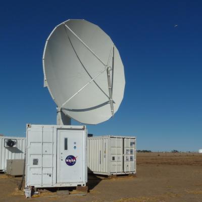
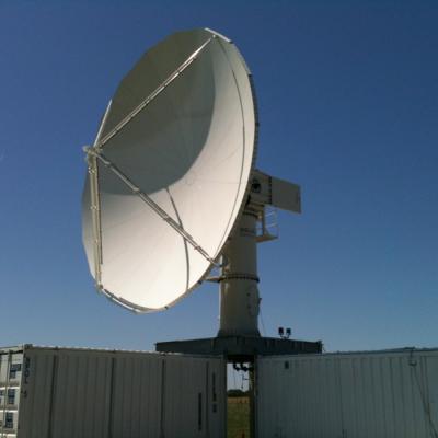
To gain a better understanding of precipitation processes and to assess and refine the physical assumptions that go into the GPM algorithms, the ground validation team makes field measurements of specific parameters that describe the physical characteristics and variability of rainfall, including rainfall intensity, distribution, particle shape and precipitation type. Ground validation uses specific ground instrumentation infrastructure developed to observe, quantify and document the physical properties of precipitation. These instruments include: The NASA NPOL radar A research grade S-band...
GPM flying over Earth with a data swath visualized.
Integrated hydrologic validation assesses GPM precipitation products by considering how the accuracy of rainfall products being input into hydrological and land-surface modeling affects model outputs. The end goals are to evaluate satellite precipitation measurements for their impacts and utility, and to provide guidance to algorithms that turn satellite retrievals into meaningful estimates of precipitation. The integrated hydrologic modeling process provides a vehicle to evaluate precipitation inputs over a given hydrological basin (watershed) where the surface inputs (land cover, soil type)...
GPM flying over Earth with a data swath visualized.
Physical validation activities collect targeted datasets that describe precipitation physics: the size, type, shape and number of raindrops throughout the air column from the cloud to the ground. Scientists use ground validation measurements to evaluate specific assumptions or hypotheses related to the physical behavior of precipitation, and the manner in which those characteristics are, or are not, well represented in a given retrieval algorithm. The goal of this validation process is to improve and fully develop physically-based precipitation retrieval algorithms. These algorithms are the...
GPM flying over Earth with a data swath visualized.
In addition to the PMM satellites, TRMM and GPM, roughly a dozen other satellites carry precipitation-relevant sensors. The goal of multi-satellite algorithms is to use “all” of the available quasi-global precipitation estimates computed from this international constellation of satellites to create a High-Resolution Precipitation Product with complete coverage over the chosen domain and period of record (currently 50°N-50°S, 1998-present). Estimates based on microwave and combined radar/radiometer input data have higher quality due to the physically direct relationships that exist between...
GPM flying over Earth with a data swath visualized.
Precipitation radiometers provide additional degrees of freedom for interpreting rain and snow in clouds through the use of multiple passive frequencies (9 for TRMM and 13 for GPM). Brightness temperatures at each frequency are a measure of everything in their field of view. These frequencies from the low (10 GHz) end to the high (183 GHz) end transition from being sensitive to liquid rain drops to being sensitive to the snow and ice particles. So, simplifying, when there is liquid rain in the cloud column, the low frequency channels will respond; when there is snow the high frequency channels...
GPM flying over Earth with a data swath visualized.
The combined use of coincident active and passive microwave sensor data provides complementary information about the macro and microphysical processes of precipitating clouds which can be used to reduce uncertainties in combined radar/radiometer retrieval algorithms. In simple terms, the combined algorithms use the radiometer signal as a constraint on the attenuation seen by the radar. The combined retrievals produce a hydrometeor profile, particle size distribution and surface parameters for which brightness temperatures and reflectivities are consistent with the actual satellite measurements...
GPM flying over Earth with a data swath visualized.
The unique function of precipitation radars is to provide the three-dimensional structure of rainfall, obtaining high quality rainfall estimates over ocean and land. Radar measurements are typically less sensitive to the surface and provide a nearly direct relationship between radar reflectivities and the physical characteristics of the rain and snow in a cloud. Because of the complexities of operating radar in space, limited channels (frequencies) are designed for the instruments. TRMM has a single frequency radar at the Ku-band particularly sensitive to moderate rain rates. With a single...
GPM flying over Earth with a data swath visualized.
The Light Precipitation Evaluation Experiment (LPVEx) took place in the Gulf of Finland in September and October, 2010 and collected microphysical properties, associated remote sensing observations, and coordinated model simulations of high latitude precipitation systems to drive the evaluation and development of precipitation algorithms for current and future satellite platforms. In doing so, LPVEx sought to address the general lack of dedicated ground-validation datasets from the ongoing development of new or improved algorithms for detecting and quantifying high latitude rainfall...
The NPOL instrument, a large radar dish attached to a trailer under a blue sky
Mid-latitude Continental Convective Clouds Experiment The Midlatitude Continental Convective Clouds Experiment (MC3E) took place from April 22 – June 6, 2011, near Lamont, Oklahoma in the region surrounding the Department of Energy (DOE) Atmospheric Radiation Measurement (ARM) Program Southern Great Plains Central Facility. The experiment was a collaborative effort between the U.S. Department of Energy (DOE) Atmospheric Radiation Measurement (ARM) Climate Research Facility and the NASA's Global Precipitation Measurement (GPM) mission Ground Validation (GV) program. The MC3E ideal scenario...