Science

Science content

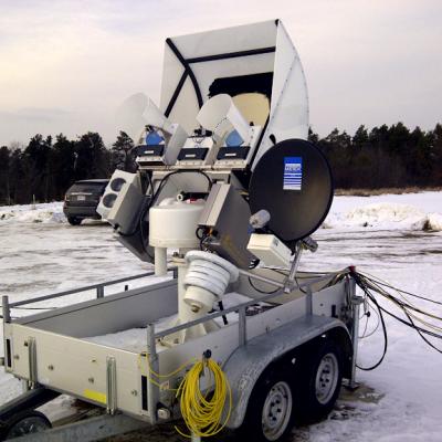
Up in the Air in the DC-8 Over the Weekend

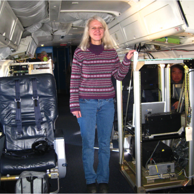
Gail Skofronick-Jackson is the Deputy Project Scientist for GPM at Goddard Space Flight Center in Greenbelt, Md. She specializes in the remote sensing of snow, and is currently in Bangor, Maine where the DC-8 airborne research laboratory is stationed for the GCPEx campaign. She wrote to us over the weekend about Saturday's flight to get background measurements from no-snow conditions. Interior of the DC-8 plane. Look at all that legroom! Credit: NASA / Gail Skofronick-Jackson Today we are taking a short flight to measure surface information over our GCPEx field campaign region. It is important

Day 2: Planning for Snow

Ben Johnson is a scientist at Goddard Space Flight Center who specializes in remote sensing of snow. This week he is at the CARE site in Ontario as one of the mission scientists for the GCPEx ground validation. Inside the operations trailer. It's a cramped and busy space. Credit: NASA / Ben Johnson Tuesday night we had a good snowfall after having rain for most of the day. About 5-10 cm of snow fell in a very short amount of time. We were able to get some good measurements from the ground equipment, some of which is shown in the pictures. Also, the NASA DC-8 aircraft arrived in Bangor Maine

Laying the Groundwork - First Photos from the Field!

GPM's ground validation scientist, Walt Petersen sent us our first photos from the CARE site in Ontario, Canada. Snow's already on the ground, now we're just waiting for more to fall! The University of Bonn ADMIRARI Radiometer deployed at the CARE site. It measures microwaves that are naturally emitted from Earth's surface to determine water vapor and cloud and liquid water in the air column. Credit: NASA / Walt Petersen The NASA D3R radar deployed at the CARE site. This radar scans the air column for snow falling from the clouds to the ground. It uses two frequencies that together can

Day 1: GCPEx Commences

Today the GPM Cold-weather Precipitation Experiment (GCPEx) officially began, and instead of snow, all that came down from the sky was cold rain. Location of the GCPEx experiment Fortunately Environment Canada's Weather Office says significant snow (and, yes, freezing rain, too) is on the horizon for Southern Ontario, where ground stations instrumented to within an inch of their lives are situated. The main GCPEx ground station is at the Centre for Atmospheric Research Experiments (CARE) in Egbert, Ontario, about 44 miles (70 km) north of Toronto and about 27 miles (44 km) southeast of Lake
GPM flying over Earth with a data swath visualized.
The GCPEx observing strategy framework is designed to use a combination of multi-frequency radar, particle imaging and water equivalent-measuring surface instrumentation in conjunction with airborne dual-frequency radar, high frequency radiometer and in situ microphysics observations arranged in stacked altitude patterns to provide the most complete coupled sampling of surface and in-cloud microphysical properties possible. The resulting 3D volumes will be combined to provide a fundamental description of snowfall physics at the ground and through the atmospheric column, and to create an...
GPM flying over Earth with a data swath visualized.
The primary objectives of GCPEx are to obtain coordinated high quality in situ and remote sensing observations of falling snow events in a northern latitude climate. Such systems are prevalent in the Ontario region in the December- February timeframe where monthly mean snowfall amounts are approximately 40, 30 and 25 cm/month for December, January and February, respectively. Furthermore, the primary choice for DC-8 operations (Bangor, Maine) will allow potential sampling of Nor’Eastern Blizzards and heavy snow events over St. Johns Newfoundland (site of current NCAR snowfall measurements...
GPM flying over Earth with a data swath visualized.
To augment the observations and provide additional test cases for synthetic algorithm development and satellite simulator testing, a number of modeling activities are also planned. Cloud resolving model simulate frozen precipitation events using the GSFC-Weather Research and Forecasting (WRF) will be performed, initialized and forced by appropriate NWP forecast models. The GSFC WRF has single-moment Goddard Microphysics and spectral-bin microphysics. All of the microphysical schemes have their own set of unique capabilities and assumptions, and all will be tested by the GPM groups. In turn...
GPM flying over Earth with a data swath visualized.
Frozen precipitation is particularly difficult to measure from space due to the wide variability in snowflake shapes and behavior. Snowflakes can have different impacts on the active and passive instruments signals compared to liquid precipitation, which is further complicated by a weak signal to noise ratio resulting from different scattering properties of liquid verses frozen precipitation. In recent years, the capability to quantify liquid precipitation from space has been greatly enhanced with the addition of several measurement capabilities from low-Earth orbit, most notably from passive...
GPM flying over Earth with a data swath visualized.
Falling snow is critically important for society in terms of freshwater resources, atmospheric water and energy cycles, and ecosystems. However, there are few archives of falling snow around the world that can be used to improve measurements from satellites. GCPEx will make detailed in situ observations of cloud and frozen precipitation microphysics to improve these databases. Falling snow represents a primary contribution to regional atmospheric and terrestrial water budgets, particularly at high latitudes. While often overlooked, precipitation falling in the form of snow is critically...
GPM flying over Earth with a data swath visualized.
Precipitation Measurement Mission Science NASA’s Precipitation Measurement Missions (PMM) develop and deploy advanced space-borne sensors to gain physical insights into precipitation processes and to enable improved monitoring and forecasting of climate, weather and precipitation-related natural hazards. PMM includes the Tropical Rainfall Measuring Mission (TRMM) and the Global Precipitation Measurement (GPM) mission. TRMM and GPM pursue a unique and innovative approach to measuring precipitation from space through the collection of observations by both active and passive sensors , which are...