

GCPEx: Field Site
The primary objectives of GCPEx are to obtain coordinated high quality in situ and remote sensing observations of falling snow events in a northern latitude climate. Such systems are prevalent in the Ontario region in the December- February timeframe where monthly mean snowfall amounts are approximately 40, 30 and 25 cm/month for December, January and February, respectively. Furthermore, the primary choice for DC-8 operations (Bangor, Maine) will allow potential sampling of Nor’Eastern Blizzards and heavy snow events over St. Johns Newfoundland (site of current NCAR snowfall measurements supporting aviation research). A deployment to the Ontario region in January 2012 therefore provides an ideal opportunity to observe several types of falling snow events with cloud tops ranging from 1 km to ~9 km.
The Centre for Atmospheric Research Experiments (CARE) is an atmospheric research facility operated by the Air Quality Research Branch of the Meteorological Service of Canada. It is located 80 km north of Toronto, Ontario, Canada in a rural agricultural and forested region (Egbert, Ontario, lat = 44° 13' 58.44"N = ~44.23, lon = 79° 46‟ 53.28"W = ~-79.78). CARE was designed as an integrated multi-disciplinary facility to promote atmospheric research. The CARE site was the major site for the C3VP ground operations in 2006-2007.
The expected instruments at CARE during GCPEx include:
- NASA D3R Ka-Ku band radar
- McGill U. Vertically pointing X, and W-band radars
- EC Precipitation Occurrence Sensing System disdrometer (POSS)
- Duke L-band snow water equivalent/rate measurement system
- EC 10-89 GHz ground staring radiometer
- NASA or EC Micro Rain Radar (MRR)
- NASA 2D Video and Parsivel disdrometers
- NASA Snow Video Imager (SVI)
- NASA OTT Pluvio2 200 and 400 cm2 snow weighing gauges
- NASA TPS-3100 Hot Plate sensor
- U. Bonn ADMIRARI
- University of Cologne, Dual-Frequency Profiling Radiometer
- EC/CARE Radiosondes
- EC Geonor weighing gauge (climate reference)
- EC Surface met tower
- EC TP3000 microwave radiometer
- EC dual channel vertically pointing lidar
- Snow tube measurements to infer snow density
- U. Manitoba high resolution imagery of individual snow particles
- Weekly physical snowpack measurements (depth, density, SWE, stratigraphy, grain size)
These measurements will provide combined and redundant surface remote sensing of falling snow water equivalent rates, snow pack water equivalent, microwave surface emission properties, PSD’s, snowfall bulk density and snow particle habits. Collectively the surface measurements will enable basic studies of snowfall characteristics to be completed at the ground, and will provide for redundant calibration of multi-frequency/polarimetric radar/radiometer sampling/diagnostics of similar bulk properties observed in the column.
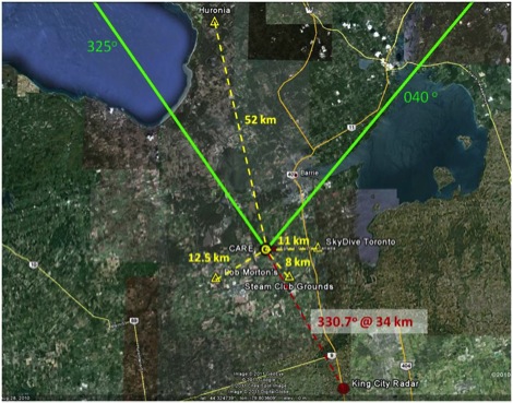 Layout of the primary (CARE) ground site along with the secondary sites GCPEx East (SkyDive), GCPEx South (SteamShow Fairgrounds), GCPEx West (B. Morton), and Huronia airport. Distances between sites and CARE are indicated. Location of the King City Radar with azimuth and range to CARE site is also indicated.
Measurements conducted at the secondary sites represent a slightly reduced capability to that available at the CARE site. The intention is to provide a suite of basic measurements to enable measurement of precipitation profile, snow water equivalent rates, snow pack water equivalent, PSD and bulk snowfall density information. These measurements provide a means to extend and calibrate volumetric radar products over the broader domain sampled by the King City radar (more appropriate to the scale of satellite footprint) and also a means to connect airborne measurements to locations at the ground other than the CARE Facility. Another benefit of the secondary sites is to allow for better chances to sample lake effect events which tend to be localized and spatially fine-scale (thus not necessarily always over the CARE facility.
Each of the sites will contain the following set of basic instruments placed in a wind abatement fence designed around the notion of the WMO Double Fence International Reference standard (DFIR).
- EC Precipitation Occurrence Sensing System disdrometer (POSS)*
- NASA or EC Micro Rain Radar (MRR)
- NASA 2D Video and Parsivel disdrometers
- NASA OTT Pluvio2 200 and 400 cm2 snow weighing gauges
- NASA TPS-3100 Hot Plate sensor
- EC Surface met tower
- A ceilometer and a visibility/present weather sensor at the secondary snow site
Next Topic: Observational Strategy and Instruments