

GCPEx: Observational Strategy and Instruments
The GCPEx observing strategy framework is designed to use a combination of multi-frequency radar, particle imaging and water equivalent-measuring surface instrumentation in conjunction with airborne dual-frequency radar, high frequency radiometer and in situ microphysics observations arranged in stacked altitude patterns to provide the most complete coupled sampling of surface and in-cloud microphysical properties possible. The resulting 3D volumes will be combined to provide a fundamental description of snowfall physics at the ground and through the atmospheric column, and to create an associated database of scenes for evaluating and developing satellite snowfall retrieval algorithms. This “algorithm laboratory” can be used to test the fundamental capabilities of current and proposed sensors for detecting and estimating falling snow over complex land and lake surfaces. Furthermore, cloud resolving model simulations of snow events occurring during GCPEx will augment the observations. With this experiment strategy, GCPEx can be used to quantify the impacts of assumptions in current algorithm formulations, and to explore new retrieval techniques.
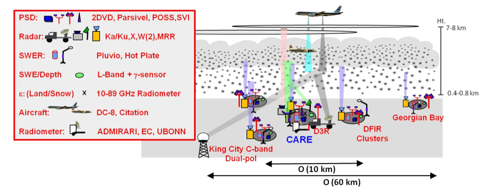 Measurement strategy concept.
The expected GCPEx instruments and parameters to be measured are provided in Table 1. The experiment will consist of DC-8, Citation, and C580 coordinated flights within a domain covered by one primary (CARE) location and four secondary ground sampling locations in Ontario, Canada about 70 km north of Toronto, and surrounded by the Great Lakes. The ground instruments at the primary and secondary sites will be used to collect microphysics information from multi-parameter radars, including the King City C-band dual-polarimetric radar. At the CARE site, scanning Ka-Ku band radar coverage will be combined with vertically pointing radar measurements and also coordinated with airborne sampling. The ADMIRARI radiometer/MRR combination will be located at the CARE site to collect combined K-band and radiometer data of either the D3R or the King City radar to facilitate studies of snow and cloud water content detection. Radiosonde profiles of temperature, pressure, humidity and wind will be collected prior to and after airborne missions to quantify tropospheric thermodynamic structure. Atmospheric profiling and surface characteristics of the snowpack will be sampled at the surface sites.
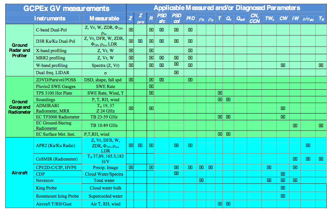 Table 1: Instrumentation and measurements for GCPEx
For airborne sampling the DC-8 will use a single radiometer spanning the 50-183 GHz and a Ku/Ka radar. The DC-8 serves as a GPM satellite simulator. Aircraft flights will occur during snow events, with the exception of several planned DC-8 missions designed to measure surface emission during intervening cloud free periods of the campaign. Occasionally these aircraft operations will occur during NOAA (or potentially CloudSat) overpass times for coincident measurements of high frequency passive microwave precipitation estimates from the AMSU-B/MHS instruments and from the CloudSat. More details about the ground observations are provided in the GCPEx Science Plan.
More Information: GCPEx Campaign Blog