GPM

Content which is affiliated solely with the Global Precipitation Measurement Mission.

V04 Processing Processing of GMI GPROF Retrievals Begins

V04 Processing processing of GMI GPROF retrievals began at 11:20 UTC, May 2. Please note the the GPM Near-realtime (NRT) subsystem began to run the V04A GPROF precipitation retrieval effective 11:20UTC, May 2, 2016. Information about changes in the version can be found in the document GMI.V4.Release.Notes_05.01.2016.pdf that is located in directory /NRTPUB/V4ReleaseInfo The biggest change in the retrieval is the use of an a-priori database constructed from Combined and KU actual mission retrievals rather than the pre-launch composite databases. Partner radiometer (both conincally scanning and

Severe Weather In Tornado Alley And Eastward

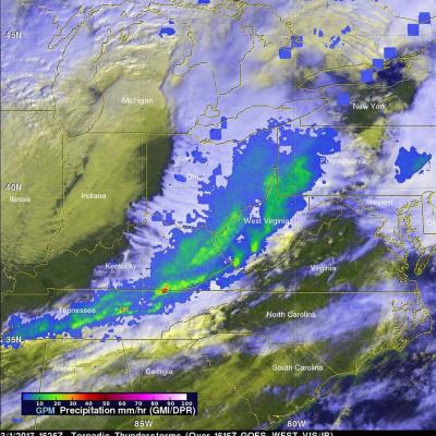
Severe spring thunderstorms frequently spawned tornadoes from the Gulf Coast north and eastward during the past week. Gulf moisture clashing with frontal systems moving over the United States provided much of the fuel for intense showers and severe thunderstorms. Flash flooding was often the result of the sudden onset of extremely heavy rainfall. Over 305 mm (12 inches) of rain was reported in southern Mississippi in a few hours one morning on April 28, 2016. NASA's Integrated Multi-satellitE Retrievals for GPM (IMERG) data were used to estimate the amount of rain that fell from April 22-29

F17 SSMIS Data Processing on Hold

There continues to be intermittent anomalies in the F17 37v channel. The science team is in the process of making a decision on how to proceed forward with the F17 SSMIS data. PPS will be halting L1C forward production of the F17 data until a decision is reached. Please note that this information pertains only to the PPS Standard Research products. Additional information will be sent for NRT (Near realtime) as appropriate. We apologize for any inconvenience or problems that this may cause and appreciate your continued patience. We will send notification updates whenever we receive new

Tropical Cyclone Fantala's Changes Observed By GPM

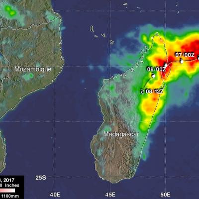
As expected, tropical cyclone Fantala reversed course and moved southeastward almost directly over it's earlier track. The tropical cyclone's intensity also fluctuated. Maximum winds dropped significantly as Fantala moved southeastward but have rebounded somewhat today. The GPM core observatory satellite flew over the tropical cyclone on April 19, 2016 at 1346Z when winds had dropped to about 95 kts (109 mph). At that time GPM's Microwave Imager (GMI) and Dual-Frequency Precipitation Radar (DPR) found that Fantala still contained extremely heavy rainfall in storms spiraling into the tropical

Slow-moving Frontal System Brings Heavy Rains, Flooding to Parts of Texas

A slow-moving frontal system associated with a stagnant upper-air pattern set the stage for heavy rains and flooding early this week from East Texas all the way up through the Central and Northern Plains. The hardest hit region was in and around the Houston area. On Monday, the National Weather Service reported that Houston International Airport broke its all time daily rainfall record with 9.92 inches of rain. Elsewhere in Harris County, over 17 inches of rain was recorded as of Monday evening. The main culprit was a stationary upper-level low pressure center spinning over the Central Rockies

IMERG Early/Late Run Precipitation Anomalies

Beginning on April 6, anomalies in the input SSMIS F17 precipitation estimates were detected in the IMERG Early and Late runs. These anomalies manifest as episodic “swath shaped” areas of high precipitation over land which appear to affect most orbits to some degree. The root cause is degradation in the 37 GHz V polarization channel. On April 13 the issue was somewhat mitigated but we continue to monitor the situation. Please let us know if you detect these (or other anomalies) in the IMERG Early and Late Runs after April 13.

GPM Views Increasingly Powerful Tropical Cyclone Fantala

Tropical cyclone Fantala has continued to intensify while moving westward over the open waters of the South Indian Ocean. The GPM core observatory satellite passed directly over Fantala's eye on April 14, 2016 at 0148 UTC. At that time the tropical cyclone had maximum sustained winds estimated at 90 kts (104 mph) making in the equivalent of a category two tropical cyclone on the Saffir-Simpson hurricane wind scale. GPM's Microwave Imager (GMI) and Dual-Frequency Precipitation Radar (DPR) instruments again captured data that were used to estimate rainfall within Fantala. Rain was measured by

Tropical Cyclone Fantala Formation Seen By GPM

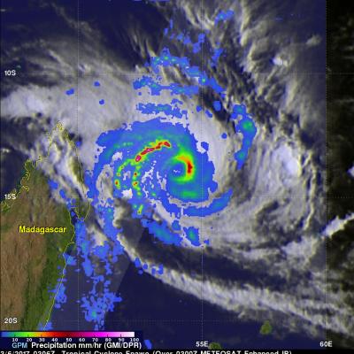
A tropical cyclone called Fantala formed in the South Indian Ocean far to the east of Madagascar on on April 11, 2016. Fantala has slowly intensified while moving westward and is expected become even more powerful. The GPM core observatory satellite flew over Fantala (TC19S) on April 10, 2016 at 0206 UTC when the tropical cyclone was forming. The first image shows a rainfall analysis using data captured with by GPM's Microwave Imager (GMI) and Dual-Frequency Precipitation Radar (DPR) instruments. GPM rainfall is shown overlaid on a 0200Z METEOSAT-7 Visible and Infrared image. Intense

Weakening Tropical Cyclone Zena's Rain Measured By GPM

Heavy rain was reported as weakening tropical cyclone Zena passed quickly by Tonga. Tropical cyclone Zena was in the process of being torn apart with strong vertical wind shear. The GPM core observatory satellite passed above Zena on April 7, 2016 at 0841 UTC after the center of the tropical cyclone had moved to the east-southeast of Tonga. Zena's maximum sustained winds had dropped to about 35 kts (40 mph). Rainfall derived from GPM's Microwave Imager (GMI) data are shown overlaid on a 0900 UTC GOES-WEST enhanced infrared image. GPM's GMI revealed that weakening tropical cyclone Zena still

GPM Sees More Powerful Tropical Cyclone Zena

Tropical cyclone Zena intensified over the open waters between Vanuatu and Fiji. At peak intensity Zena had sustained winds estimated at about 90 kts (104 mph). The GPM core observatory satellite had an excellent view of tropical cyclone Zena on April 6, 2016 at 0933 UTC when tropical cyclone Zena was located southwest of Fiji. Zena had started to weaken but still had maximum sustained wind speeds estimated at 80 kts (92 kts). An analysis of GPM's Microwave Imager (GMI) and Dual-Frequency Precipitation Radar (DPR) data revealed the intensity of some very heavy showers in the tropical cyclone