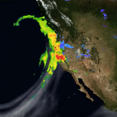
After more than four years of drought, Californians may wonder where the current rain is coming from. Using satellites, NASA scientists have a unique view of the sources of precipitation, and how it reaches the western United States.
After more than four years of drought, Californians may wonder where the current rain is coming from. Using satellites, NASA scientists have a unique view of the sources of precipitation, and how it reaches the western United States. Rain is often carried by narrow tendrils of moisture called atmospheric rivers that occur all over the world, shown here in white. The atmospheric rivers that affect the western United States are known as the Pineapple Express because they transport water vapor from as far south as Hawaii to California. When the moisture reaches land, it is forced up over the...
Widespread flooding has recently caused the deaths of dozens of people in southern Thailand. Frequent and persistent downpours have resulted in record rainfall totals. NASA's Integrated Multi-satellitE Retrievals for GPM (IMERG) were used to estimate the total amount of rain that fell over southern Thailand during the past week. Extreme rainfall totals of over 700 mm (27.6 inches) were shown over the Gulf of Thailand. The highest rainfall total estimates over land were greater than 500 mm (19.7 inches) on the eastern coast of the Malay Peninsula in the Bang Saphan district. Rainfall has
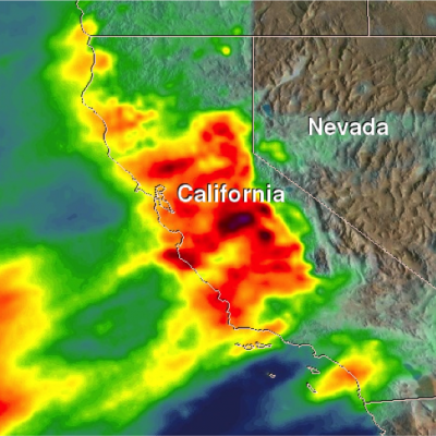
An atmospheric river (“Pineapple Express”) delivered over 5 inches of rainfall in parts of California during January 3-10, 2017 (bottom) as viewed by GPM’s IMERG data. California, which has long been suffering through a strong, multi-year drought, is finally beginning to see some much needed relief as a result of a recent series of storms that are part of a weather pattern known as the “Pineapple Express.” The Pineapple Express is known as an atmospheric river. A large, slow-moving low pressure center off of the West Coast taps into tropical moisture originating from as far south as the
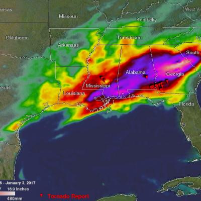
Severe thunderstorms spawned tornadoes and generated flooding rainfall over the Southeast on Monday evening. At least twelve tornadoes were reported with twisters spotted in Mississippi, Alabama and Georgia. Four deaths in Alabama and one in Florida have been blamed on this violent weather. Total rainfall was measured from December 30, 2016 through early January 3, 2017 using precipitation estimates from NASA's Integrated Multi-satelliE Retrievals for GPM (IMERG) data. IMERG data are produced using data from the satellites in the GPM Constellation, and is calibrated with measurements from the
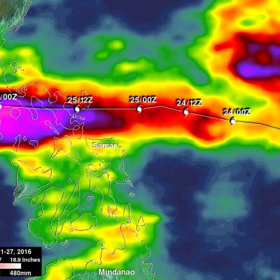
Heavy rainfall and winds from super typhoon Nock-ten caused the deaths of at least six people as it roared through the Philippines. Data generated by NASA's Integrated Multi-satellitE Retrievals for GPM (IMERG) were used to estimate the total amount of rain that super typhoon Nock-ten dropped as it approached and traveled over the Philippines. Nock-ten’s approximate locations and appropriate tropical cyclone symbols at 0000Z and 1200Z are shown overlaid in white on IMERG rainfall estimate images. This IMERG analysis shows estimated rainfall totals using NASA's IMERG data produced during the
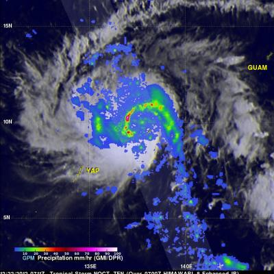
Heavy precipitation and strong winds from typhoon Nock-ten are expected over the Philippines for several days as the country is celebrating the Christmas holiday. Tropical storm Nock-ten is predicted by the Joint Typhoon Warning Center (JTWC) to strengthen into a powerful typhoon with winds of about 105 kts (121 mph) before it reaches the Philippines. Nock-ten is predicted to weaken after hitting the eastern Philippines but still have winds of over 80 kts (92 mph) as it travels close to Manila, the country's capital. The GPM core observatory satellite had a good view of Nock-ten when it passed
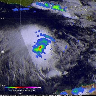
The GPM core observatory satellite again flew over tropical cyclone Evette (02S), located off the northwestern coast of Australia, on December 21, 2016 at 0941 UTC. Maximum sustained winds had increased to about 40 kts (46 mph). The GPM satellite's Microwave Imager (GMI) revealed that the area of continuous rainfall around Yvette's center of circulation had increased in size. Convective storms were shown by GPM to be dropping rain at rates of over 60 mm (2.4 inches) per hour. Tropical cyclone Yvette is predicted to intensify slightly by tomorrow to about 50 kts (58 mph). Yvette continues to be
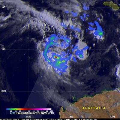
Australia is normally affected by 11 cyclones a year but only three formed during Australia's last summer. This year sea surface temperatures in the tropical waters around Australia are much warmer so an average tropical cyclone is forecast by the Bureau of Meteorology (BOM). Tropical cyclone 02S formed in the Indian Ocean northwest of Australia yesterday. Another tropical cyclone is also expected to form soon in an area of intense convection west-northwest of Darwin, Australia. The GPM core observatory satellite flew above tropical cyclone 02S just a few hours after it's formation on December
PPS received replacement PRL1KA/KU files from JAXA. PPS will reprocess the affected data including combined and downstream products (2AKa, 2AKu, 2ADPR, 2BCMB, 2HCSH, 2HSLH, 3GCSH, 3GSLH) from 2016-12-17 16:31:39 -> 2016-12-17 18:04:13. If you have obtained any of these products from our archive or through a Standing Order, etc., please discard these and use the replacement products. -------------------------------------------------------------------------- The following files and corresponding browse products will be replaced 2A.GPM.Ka.V6-20160118.20161217-S163139-E180413.015932.V04A.HDF5 2A