TRMM

Content which is associated solely with the Tropical Rainfall Measuring Mission.

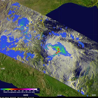
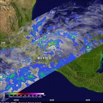
Heavy Rainfall on Mexico's Pacific and Gulf Coasts

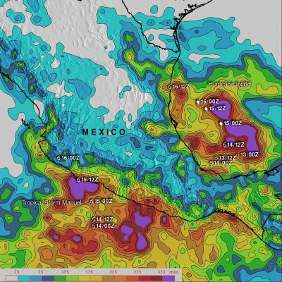
Mexico's Pacific and Gulf coasts are both being inundated by tropical cyclone rainfall at the same time. Tropical storm Manuel has dropped very heavy rainfall along Mexico's Pacific coast. 21 people have been reported killed in this area due to flooding and landslides caused by extreme rainfall. At the same time hurricane Ingrid weakened to a tropical storm and came ashore from the Gulf Of Mexico into the state of Tamaulipas near La Pesca, Mexico . The approximate 0000Z and 1200Z locations of the tropical cyclones are shown overlaid in white. The TRMM-based, near-real time Multi- satellite

Hurricane Ingrid Heads For Mexico

The TRMM satellite flew over on September 16, 2013 at 0227 UTC (10:57 PM September 16) when Ingrid was still a hurricane in the Gulf Of Mexico. Data collected by TRMM's Microwave Imager (TMI) and Precipitation Radar (PR) instruments show that rain was falling at a rate of over 100mm/hr (~4 inches) in strong storms near Ingrid's center.

Tropical Storm Ingrid Getting Stronger

Tropical storm Ingrid in the southern Gulf Of Mexico was strengthening when the TRMM satellite flew over on September 13, 2013 at 2008 UTC (4:08 PM EDT). A band of very strong convective storms north of Ingrid's center was observed by TRMM's Precipitation Radar (PR) instrument to contain rain falling at the rate of over 143 mm/hr (~5.6 inches). Powerful thunderstorms in this area were also found by TRMM PR to reach heights above 16km (~9.9 miles). These "hot towers" are often a sign that a tropical cyclone will intensify.

Tropical Depression Gabrielle

Tropical Storm Gabrielle passed close to Bermuda on Wednesday and has now moved out of the TRMM satellite's coverage area (40N-40S). Tropical depression Gabrielle is currently moving over the open waters of the North-Atlantic toward Newfoundland and is predicted to be absorbed by a front tomorrow. A red tropical storm symbol shows the location of Gabrielle's nearly rain free center when TRMM passed above on Thursday September 12, 2013 at 2249 UTC (6:49 PM EDT).

Weaker Hurricane Humberto

Southwesterly wind shear has taken it's toll on hurricane Humberto. An eye was no longer distinct in data collected when the TRMM satellite passed over on September 12, 2013 at 1625 UTC (12:25 PM EDT). An analysis derived from TRMM Microwave Imager (TMI) and Precipitation Radar (PR) data shows that most of the precipitation with Humberto was then located in the northwestern quadrant. TRMM found that the most intense rain was falling at a rate of over 99mm/hr (~3.9 inches) at 22.4 North 28.7 West near Humberto's center. TRMM PR also found that the highest storm towers were reaching heights of

Gabrielle Seen Knocking On Bermuda's Door

Tropical storm Gabrielle was at a distance of about 50km (~31 miles) to the south-southwest of Bermuda on September 11, 2013 at 0041 (September 10, 2013 8:41 PM EDT) when the TRMM satellite flew above. A rainfall analysis from TRMM's Microwave Imager (TMI) and Precipitation Radar (PR) is shown overlaid on an enhanced infrared image from the satellite's Visible and InfraRed Scanner (VIRS). A band of light to moderate rainfall extends to Bermuda from a large area of heavy rainfall in the eastern side of Gabrielle. A red tropical storm symbol shows the surface location of tropical storm Gabrielle

TRMM Sees Gabrielle Closing In On Bermuda

The TRMM satellite flew directly above tropical storm Gabrielle on September 10, 2013 at 2124 UTC (5:24 PM EDT) as the storm approached Bermuda. TRMM's Precipitation Radar (PR) data found that rain was falling at a rate of over 127mm/hr (~5 inches) in a line of intense storms southeast of Bermuda. TRMM PR also found that the tallest thunderstorms, reaching to heights above 15.5km (~9.6 miles), were located in an area close to Gabrielle's center of circulation. Click here to see a simulated 3-D (Quicktime) flyby animation over Gabrielle approaching Bermuda using TRMM PR data. Click here to see

Tropical Storm Gabrielle Revived

Tropical storm Gabrielle dissipated to below tropical depression intensity on September 5, 2013. Gabrielle has regenerated and was again classified this morning as a tropical storm by the National Hurricane Center (NHC). This image shows a rainfall analysis using TRMM Microwave Imager (TMI) and Precipitation Radar (PR) data collected by two orbits of the satellite. The earlier orbit was on September 10, 2013 at 0136 UTC and the second orbit occurred at 0313 UTC. The heaviest rain, falling at a rate of 54mm/hr (~2.1 inches), was found by TRMM PR in a feeder band spiraling into Gabrielle from

Tropical Depression Gabrielle

The National Hurricane Center (NHC) upgraded a low pressure center south of Puerto Rico to tropical depression number seven on September 4, 2013 at 2100 UTC (5:00 PM EDT). The tropical depression was then again upgraded to tropical storm Gabrielle on September 5, 2013 at 0300 UTC (September 4, 2013 11 PM EDT). Gabrielle was subsequently downgraded today to a tropical depression at 1500 UTC (11 AM EDT). The TRMM satellite's Microwave Imager (TMI) had a fairly good look at tropical storm Gabrielle very early this morning at 0614 UTC (2:14 AM EDT). TRMM's TMI found rain falling at a rate of over

TRMM Gets Daytime View Of Humberto

The TRMM satellite had an excellent daytime view of strong tropical storm Humberto on September 10, 2012 at 1636 UTC (~12:36 PM EDT). Rainfall derived from TRMM's Microwave Imager (TMI) and Precipitation Radar (PR) data are shown overlaid on a combination visible/infrared image from TRMM's Visible and InfraRed Scanner (VIRS). TRMM PR found that the heaviest rainfall associated with Humberto was not near the center of circulation but in convective storms west of the storm. Tropical Storm Humberto's highest winds were about 55kts (~63 mph) at the time of this TRMM pass and the National Hurricane