What is the difference between a tornado and a hurricane?

Both tornadoes and hurricanes are characterized by extremely strong horizontal winds that swirl around their center and by a ring of strong upward motion surrounding downward motion in their center. In both tornadoes and hurricanes, the tangential wind speed far exceeds the speed of radial inflow or of vertical motion.

Hurricanes always and tornadoes usually rotate counterclockwise in the northern hemisphere and clockwise in the southern hemisphere. The Earth's rotation determines this direction for the storms' rotation in each hemisphere. Local winds are sometimes able to cause a tornado to form that spins in the opposite direction from the typical direction for that hemisphere.

The most obvious difference between a tornado and hurricane is that a hurricane's horizontal scale is about a thousand times larger than a tornado. In addition, hurricanes and tornadoes form under different circumstances and have different impacts on the atmosphere.

Tornadoes are small-scale circulations, that are rarely more than a few hundred feet across when they touch the ground. Most tornadoes grow out of severe thunderstorms that develop in the high wind-shear environment of the United States Central Plains during spring and early summer.  Many tornadoes form when the large-scale wind flow leads to a violent clash between moist, warm air traveling north from the Gulf of Mexico and cold, dry, continental air coming from the United States Northwest. Tornadoes can also form in many other locations and from other forcing factors. For example, a hurricane making landfall may trigger many tornadoes to form.

Tornado wind speeds may reach 100 to 300 mph and cause havoc on the ground, but tornadoes typically last only a few minutes and rarely travel more than 10 or 20 miles along the ground. Tornadoes have little impact on storms that spawn them or collectively on the global circulation of the atmosphere.

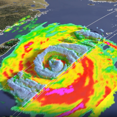
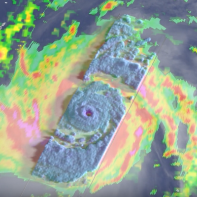
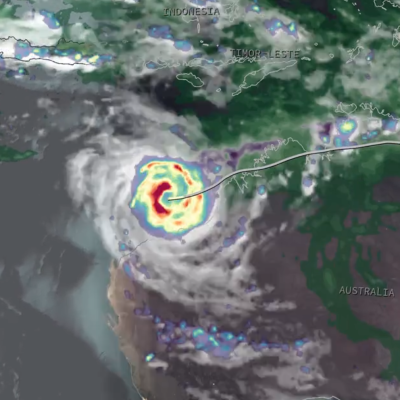
Hurricanes, on the other hand, are large-scale circulations that are 60 to over 1,000 miles across. Hurricanes form near the Equator, generally between 5 and 20 degrees latitude, but never right on the Equator. Hurricanes always form over the warm waters of the tropical oceans and generally where the sea-surface temperature exceeds 26.5°C (76°F).

A hurricane may travel thousands of miles and persist over several days or weeks. During its lifetime, a hurricane will transport a significant amount of heat up from the ocean surface and into the upper troposphere or even lower stratosphere. Even though hurricanes form only sporadically, they do affect the global atmosphere's circulation in measurable ways, although this is still an active area of research.

Extreme Weather News

Jump to a Year

2022 | 2021 | 2020 | 2019 | 2018

2017 | 2016 | 2015 | 2014 | 2013

2012 | 2011 | 2010 | 2009 | 2008

2007 | 2006 | 2005 | 2004 | 2003

2002

GPM overpass of Hurricane Erin.
After forming into a hurricane in the central Atlantic on the morning of Friday August 15 th, Hurricane Erin underwent a period of extremely rapid intensification as it was passing northeast of the Leeward Islands, becoming a powerful Category 5 storm and the most rapidly deepening hurricane in the Atlantic before the month of September. Last year in early October in the then Gulf of Mexico, Hurricane Milton became the fastest Atlantic storm to intensify from a tropical depression to a Category 5 storm. Erin originated from an African easterly wave that emerged off the coast of Africa on the 9
3D view of the Texas storms from the GPM satellite
Over the fourth of July weekend, the Texas Hill Country was devastated by a powerful flash flood event. River levels rose rapidly, on the order of 20 feet or more in 1 to 2 hours or less, all along the upper part of the Guadalupe River. The main flood event started overnight and continued throughout the morning of July 4, resulting in widespread destruction, hundreds of water rescues, many deaths, and numerous people still reported as missing. The Hill Country can be susceptible to flash floods as water tends to run off rather than being absorbed by the soil and plants. The culprit for this
Map of the U.S. showing IMERG rainfall totals over the south and central U.S.
This past week, a slow-moving, upper-level system moving through the central U.S. triggered several days of severe weather. The system caused numerous tornadoes, as well as heavy rains and flooding from the Deep South up through the middle Mississippi River Valley and into the Ohio River valley. The situation began when an upper-level area of low pressure situated over the northeast Pacific pivoted down into the central Rockies, creating a deep trough of low pressure aloft that extended down into the northern Baja. This channeled strong jet stream winds from south of the Four Corners region up
top image for Sahara 2024
Most people live in places where it rains much more often than it does in the Sahara Desert. For this reason, it can be challenging to make sense of news reports of major storms in the Sahara. NASA satellite data and rainfall statistics can give the needed context. Below is a discussion of three news stories about rainfall in or near the Sahara Desert during August and September 2024. These news stories described storm runoff, infrastructure damage, and the rain's impact on the ecosystems at the edge of the desert. Areas with significant impacts are shown in green in Figure 1. Figure 1. A map
Screenshot of IMERG rain rates on October 29, 2024
During the 10-day period from Oct. 26 through Nov. 4, 2024, parts of central-eastern and southern Spain saw unusually heavy flooding that resulted in heavy infrastructure damage and over 200 fatalities, according to the Associated Press. In this animation, NASA’s IMERG multi-satellite data product shows estimated rain rates (blue/yellow shading) and accumulations (green/purple shading) from the flooding rainfall. Cloudiness is also shown in white/gray shading, from geosynchronous infrared satellite observations. Download video (right-click -> "Save As") The flooding was caused by heavy