

Snow Much to Measure! GPM Ground Validation Instruments Take a Look at Falling Snow
Though the last traces of winter are melting away and spring showers are in full swing across the U.S., the story of snow is not quite over for the season. In mid-April, two winter field campaigns involving NASA researchers are wrapping up, bringing with them unprecedented observations of snowfall.
Understanding when, where, and how much snow is falling is critical for scientists and the public alike. In the short-term, accurate snowfall data can help weather forecasters prepare communities and plan against hazardous road conditions, power outages, and health risks. Over the long-term, these measurements are essential to assess snowpack water reserves that are vital for effective water resource management.
The NASA/JAXA Global Precipitation Measurement (GPM) mission uses satellites to measure and understand Earth’s rain and snowfall. GPM’s radar instrument, the Dual-frequency Precipitation Radar (DPR), serves as one of two advanced instruments that help observe and measure snowfall globally from space. The DPR is designed using two radar frequencies (Ku- and Ka-band) that can measure precipitation properties layer-by-layer within the storm. This capability helps to differentiate between rain, ice, and snow and provide details on precipitation particle sizes and their 3D structures. Together, these capabilities make the DPR a uniquely powerful tool for capturing snowfall information around the globe.
However, measuring falling snow in near real-time is no small feat, and it comes with challenges. Snow can have a weak reflected radar signal, and each snowflake varies in shape, structure and density, making it difficult for ground-based and satellite instruments to directly observe these properties. Adding to these complexities for satellites are complex topographies and snow-covered surfaces where radar signals may be blocked by ridgelines and snow-covered surfaces make it difficult for the radar to differentiate between falling snow and ground clutter.
To tackle these challenges, a suite of ground-based radars and snow-sampling instruments from the GPM Ground Validation (GV) program were deployed to support two winter field campaigns— the NASA GV Field Campaign at UConn (UCONN) in Storrs, Connecticut and the National Science Foundation (NSF)-funded Snow Sensitivity to Clouds in a Mountain Environment (S2noCliME) Project in Steamboat Springs, Colorado.
GPM’s ground validation program is a core component of the GPM mission. The program’s primary objective is to use ground instrumentation to observe, quantify and document the physical properties of precipitation and serve as “ground-truth” to ensure that GPM satellite data products are as accurate as possible. GPM ground validation instruments include multi-frequency dual-polarimetric radars (Ka/Ku and K bands), airborne microphysical probes, and ground-based disdrometer and raingauge networks. These instruments have the capability to capture detailed precipitation parameters including liquid water content, precipitation rates and totals, and the size and shape of hydrometeors (precipitation particles) from near-ground level to high in the atmosphere. The GPM ground validation instrument suite has been used in many field campaigns across a variety of climates and precipitation conditions. Now the UCONN and S2noCliME field campaigns have joined this effort, providing vital information on snowfall from the ground up.
S2noCliME

Claire Pettersen working on NASA supplied instrumentation at the Mid-Mountain site in Steamboat Springs, Colorado. The site included a profiling radar, disdrometer, accumulation gauge, microwave radiometer, and lidar. Credit: Pettersen
Dr. Claire Pettersen, a researcher at the University of Michigan, serves as the lead Principal Investigator for the NSF S2noCliME field campaign and is an active member of NASA’s Precipitation Science Team. S2noCliME brings researchers from multiple universities and agencies together at Storm Peak Lab atop Mount Werner, just northwest of Denver, Colorado. Storm Peak Lab’s unique location allows for continuous, ground-based cloud and precipitation sampling in the winter months, while being within the clouds 90 percent of the time during snow events.
Pettersen notes, “The project is a good example of collaborations with experts from a range of federal agencies and universities, many of which were or are actively part of NASA Precipitation Science Team community. Which means we have expertise from all different angles supplemented by the unique suite of instrumentation from the GPM ground validation group.”
For four and a half months, the team used a suite of NSF-funded instrument deployments and installations to study snowfall. This included in-situ probes at the Storm Peak Laboratory —specialized instruments placed directly in the volume of the falling snow—that captured close-up imagery of individual supercooled water droplets and ice particles. Additionally, two NSF Community Instrument Facilities (CIFs), the Colorado State University Sea-Going Polarimetric Radar and the Stony Brook University Ka-band Scanning Polarimetric Radar were installed and deployed for the entire winter. To support this instrument suite, the team also deployed several sensors provided by the GPM Ground Validation group: disdrometers, which measure snowflake size and rate; precipitation gauges, which track precipitation accumulation; and profiling radars, which help scientists understand snowfall event evolution. By integrating these in-situ and remote sensing observations over an entire winter, the S2noCliME data will greatly enhance scientists’ understanding of snowfall processes during storms in mountainous terrain.

A group of University of Michigan researchers skiing to the Storm Peak Laboratory and the Mid-Mountain site to work on instruments. Left to Right: Genny Plant (UM Researcher), Jack Richter (UM graduate student and NASA FINESST recipient), Claire Pettersen (UM Assistant Professor and S2noCliME lead PI).
“When you have snowfall happening at the top of the mountain and in the cloud, you are getting actual in-situ information about the cloud and precipitation microphysics while using these instruments, which we then can use down the line to support and enhance retrievals for GPM’s DPR data products,” said Dr. Claire Pettersen.
The team is also using the data for short- and long-term applications that can directly benefit communities around the world. The vast amount of data collected can improve snowfall forecasts, and can help more accurately predict snowpack, influencing water resource management efforts in the western U.S. mountains. With this information, the team is engaging directly with local communities to share forecasts and provide insights on water resources.
Soon after the campaign wraps up, data will be available at the NSF National Center for Atmospheric Research data archive, with the NASA instrument data also being archived within the NASA GPM Validation Data web portal. This will ease accessibility for the broader scientific community and contribute to NASA’s mission to advance remote sensing capabilities in complex terrains.
NASA GV Field Campaign at UConn

The NASA GPM Ground Validation Field Campaign at UConn is located in Storrs, Connecticut. The site has multiple instruments provided by the GPM Ground Validation Program. Credit: Diego Cerrai.
In the northeastern U.S., almost 3,200 km away from the mountainous terrain of Colorado, over 15 GPM Ground Validation winter precipitation instruments were deployed near the University of Connecticut’s campus as part of the fourth consecutive year of the NASA GV Field Campaign at UConn. This was achieved in coordination with the GPM GV Team based at NASA’s Wallops Flight Facility in Virginia. Dr. Diego Cerrai, a researcher from the University of Connecticut and Interim Director of the Eversource Energy Center, is the University lead for this field campaign. University of Connecticut’s location offers a unique opportunity to gather insights into falling snow during U.S. East coast winter storm systems, also known as “Nor’easters”.
Over the winter season, the UConn and GPM GV teams deployed several GPM Ground Validation instruments, including K-band and W-band profiling radars, Ka-Ku band scanning radars, weighing and tipping bucket pluviometers, laser disdrometers, and high-speed high-resolution cameras. These instruments are all essential to collecting an unprecedented variety of information on snowfall amounts and rates, the microphysical properties of snowflakes (shape, size, and structure) and vertical profiles of snowfall from the atmosphere down to the ground.
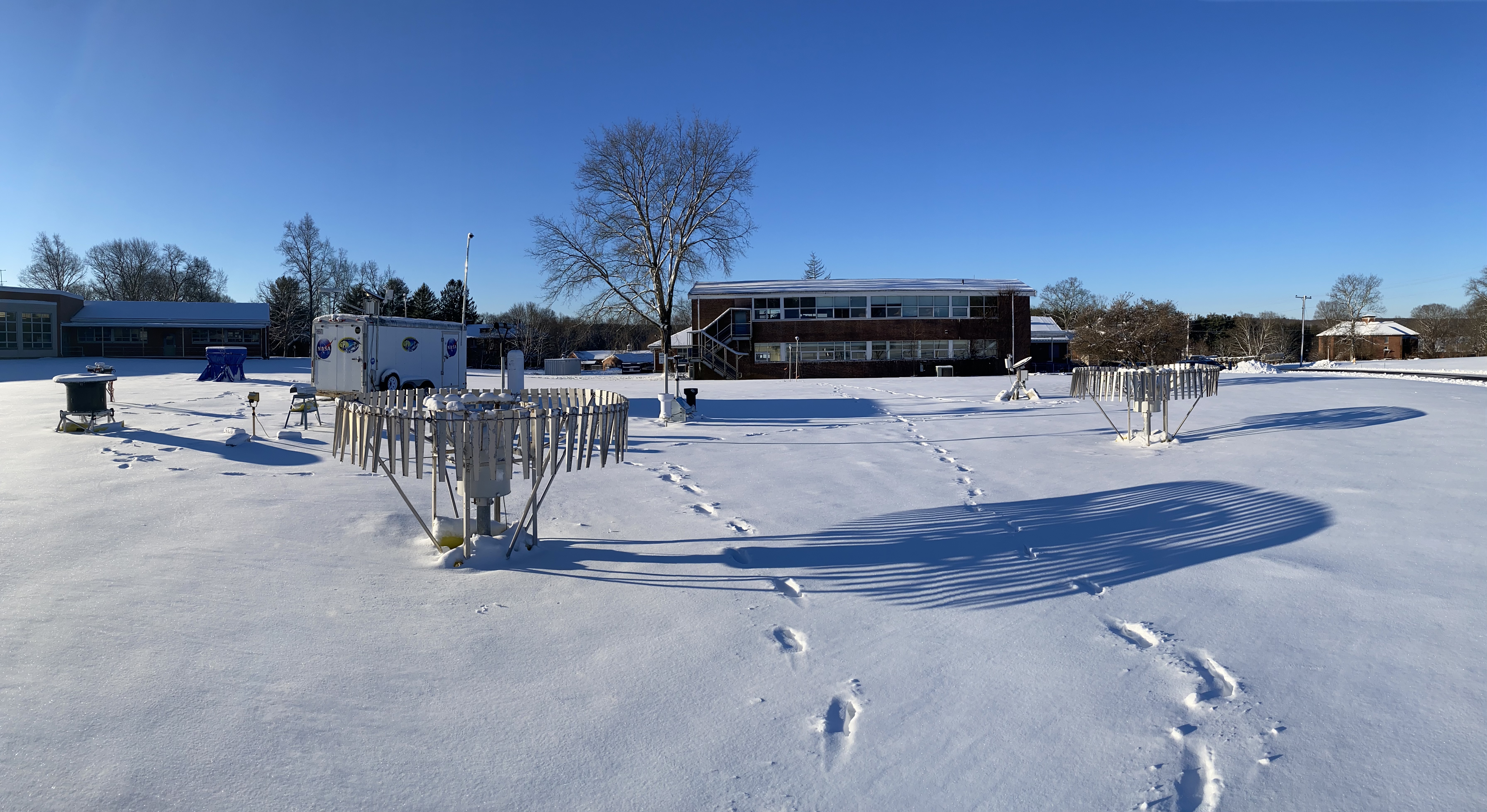
The “GAIL” site part of the NASA GPM Ground Validation Field Campaign at UConn in Storrs, Connecticut. Credit: Diego Cerrai.
“It is very difficult to find ground truth for snow, but this information is important to help improve snow data products from satellites. And very often, there are either sparse or short field campaigns in a specific area. This field campaign is unique in that we are using a lot of instruments with various techniques to measure snow characteristics - from particle size distributions to snow rates and density - in the same location over a longer period of time. This helps provide a consistent quality control database that can help validate GPM satellite precipitation retrievals,” said Dr. Diego Cerrai.
Going beyond GPM satellite instrument validation, the UCONN Field Campaign’s precipitation microphysics observations are helping scientists understand the physical processes that occur within clouds and precipitation. This can help improve the accuracy of numerical weather prediction models that forecast snow.
Diego and his team are also taking advantage of this large amount of field campaign data to develop models for predicting the impact of snowstorms for electric utilities. Accurate winter storm impact forecasts are critical for utilities to prepare more effectively and reduce outage durations caused by storms. Snow density is a very important variable for these impact models, as opposed to snowpack. Snow density influences ice accretion on infrastructure and electric grids, increasing the risk of power outages, structural failures, and maintenance demands during winter storms. Leveraging the campaign’s atmospheric snow density data, Cerrai, as part of his position as Interim Director of the Eversource Energy Center, is working with several utilities across the Northeast including Eversource Energy, Avangrid, Dominion Energy, and Exelon, to forecast ice accretion and support outage prediction models.
“NASA field campaigns, like this one, are extremely critical for advancing microphysical characterization of snow in atmospheric models that, in turn, will advance the predictability of these impacts,” said Diego Cerrai.
These efforts are ongoing and will continue to enable power utilities around the U.S. to enhance their storm preparedness and improve public safety.
UCONN Field Campaign data is hosted and freely available through the GPM Ground Validation web portal.
Harnessing Instruments for Snow Science
GPM Ground Validation instruments continue to play a critical role in field campaigns, capturing a vast amount of precipitation observations in unique and remote locations with exceptional detail and accuracy. These instruments enhance scientist’s understanding of precipitation microphysics and put science to action by supporting communities through enhanced weather forecasting, water resource management, and energy sector preparedness. Both the UCONN and S2noCliME field campaigns add to the growing legacy of the GPM Ground Validation program by expanding our understanding of precipitation processes and ensuring that NASA satellite data products accurately represent real-world processes.
LEARN MORE
- Get to Know The Scientists:
- 1-Pager Field Campaign Overviews
Credits:
Story by Andrea Portier (NASA / SSAI)
Edited by Jacob Reed (NASA / Telophase Corp.)