Ida

Hurricane Ida IMERG Totals
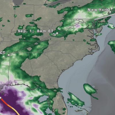
All eyes were on Hurricane Ida as it made landfall in Louisiana on Aug. 29, 2021, but many people were taken by surprise by the power of Hurricane Ida's remnants when they reached Virginia during the day on Sept.1 and New York City late at night on Sept. 1 into early morning on Sept. 2. The below animation shows the precipitation that fell during the entire lifecycle of Ida from before landfall in Louisiana through the impacts on New York City. Download this video (right-click -> "Save As") This animation uses data from the near real-time version of NASA's IMERG algorithm, a data product that
NASA/JAXA GPM Satellite Eyes Hurricane Ida Shortly Before Landfall
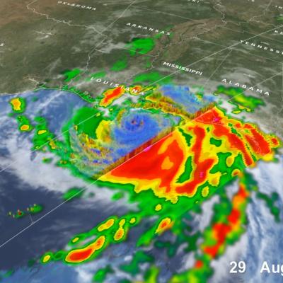
Hurricane Ida struck southeast Louisiana as a powerful Category 4 storm on Sunday, Aug. 29, 2021 - the 16th anniversary of Hurricane Katrina’s landfall in 2005. Ida brought destructive storm surge, high winds, and heavy rainfall to the region, and left over 1 million homes and businesses without power, including the entire city of New Orleans. The NASA / JAXA GPM Core Observatory satellite flew over the eye of Ida shortly before landfall at 10:13 a.m. CDT (1513 UTC), capturing data on the structure and intensity of precipitation within the storm. This animation shows NASA's IMERG multi

Ida Weakened by Strong Shear in the Atlantic

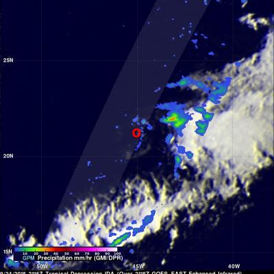
Tropical Depression Ida has struggled to maintain itself in the Central Atlantic well east of the Leeward Islands where it has been ravaged by strong wind shear. Since forming back on the 18th of September, Ida has not been able to strengthen beyond a moderate tropical storm, reaching a peak intensity of 45 knots (50 mph) early on the morning of the 21st before succumbing to the effects of strong northwesterly winds from an upper-level trough. Since that time, Ida has struggled maintain itself between a depression and a weak tropical storm, while being mired in the Central Atlantic. This most

Meandering Ida's Precipitation Measured By GPM

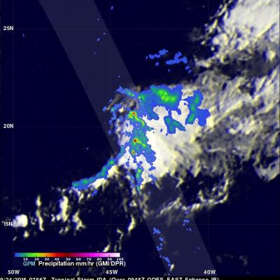
The GPM core observatory satellite had another good view of meandering tropical storm Ida located in the central Atlantic Ocean on September 24, 2015 at 0756 UTC (3:35 AM EDT). Measurements of precipitation by GPM's Microwave Imager (GMI) and Dual-Frequency Precipitation Radar (DPR) instruments showed that Ida still contained a few embedded strong convective thunderstorms that were dropping heavy rainfall. Some rainfall was measured by GPM's Ku Band radar falling at a rate of 122 mm (4.8 inches) per hour. GPM's 3-D radar reflectivity data (DPR Ku band) can be used to reveal the intensity of

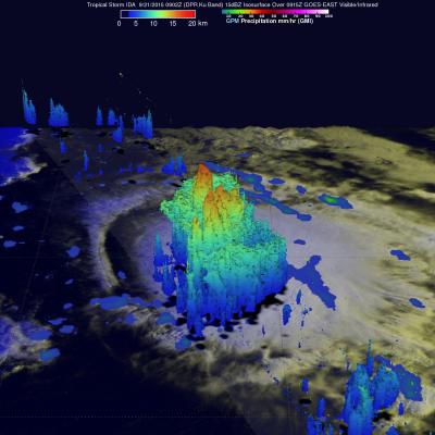
GPM Sees Powerful Storms Within Tropical Storm Ida

The GPM core observatory satellite found that tropical Storm IDA contained some very powerful convective thunderstorms when the satellite passed over on September 21, 2015 at 0902 UTC (05:02 AM EDT). The satellite passed directly above the most powerful storms within IDA where rain was measured by GPM's Microwave Imager (GMI) and Dual-Frequency Precipitation Radar (DPR) instruments. DPR found that some thunderstorms were dropping rain at a rate of over 142 mm (5.6 inches) per hour. GPM's DPR (Ku Band) radar data were used examine the 3-D structure of precipitation within tropical storm IDA