Joaquin

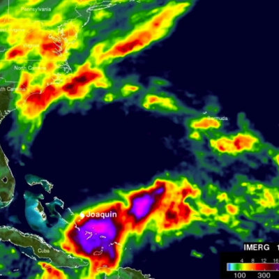
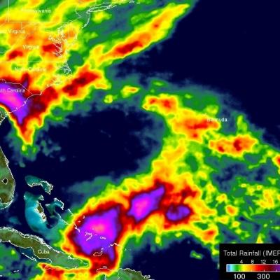
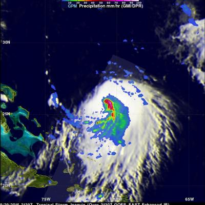
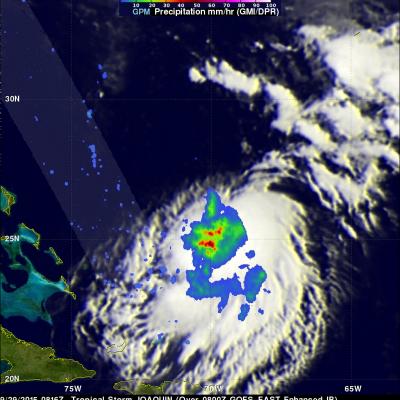
Subtropical Storm Joaquin Heads For Europe

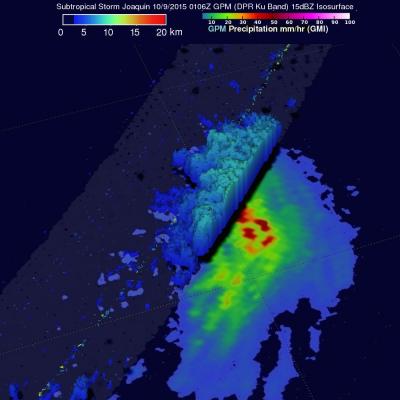
Hurricane Joaquin became subtropical while traveling over the cool waters of the North Atlantic. The low pressure center that was once powerful hurricane Joaquin was viewed by the GPM core observatory satellite on October 9, 2015 at 0106 UTC. The low pressure center was moving past the Azores toward landfall in Portugal. GPM's Microwave Imager (GMI) and Dual-Frequency Precipitation Radar (DPR) instruments measured precipitation within the low pressure center. The most intense rainfall was located northeast of the center of the low and was falling at a rate of over 54 mm (1.1 inches) per hour
NASA Aids Response to Carolina Flooding
It was rain that wouldn't quit. A weather system fueled by warm moisture streaming in from the Atlantic Ocean on Oct. 3 and 4 relentlessly dumped between one and two feet of rain across most of South Carolina. The result was rivers topping their banks and dams bursting. Catastrophic flooding followed across most of the state, which has left residents in some areas without power or clean drinking water. Tracking and predicting the deluge, both as rain and then floodwater, are the first steps to help protect people in harm's way. State and federal emergency managers have been on the front lines...

IMERG Measures Historic Rainfall With A Nor'easter and Joaquin

NASA's Integrated Multi-satellitE Retrievals for GPM (IMERG) data were used to estimate the historic amount of rain that fell during the past week in the Carolinas. A "fire hose" of moisture has been pumped into the Carolinas from hurricane Joaquin resulting in wide spread flooding. Over two feet of rain have been reported in South Carolina. This analysis indicated that major hurricane Joaquin also dropped over 700 mm (27.5 inches) in the Bahamas. Hurricane Joaquin has weakened from a category four hurricane in the Bahamas to a category one hurricane affecting Bermuda. Click here to see a

Joaquin Becomes a Hurricane, Could Impact the US East Coast

Joaquin, which became a tropical storm Monday evening (EDT) midway between the Bahamas and Bermuda, has now formed into a hurricane, the 3rd of the season--the difference is Joaqin could impact the US East Coast. GPM captured this image of Joaquin late yesterday afternoon at 21:39 UTC (5:39 pm EDT) on the 29th of September as Joaquin was moving very slowly towards the west-southwest about 400 miles east of the northwestern Bahamas. This first image shows rain rates derived from GPM's GMI microwave imager (outer swath) and DPR space-borne precipitation radar (inner swath) overlaid on IR data

Tropical Storm Joaquin forms in the Western Atlantic

Tropical Storm Joaquin became the 10th named storm of the season after forming late last night (EDT) in the western Atlantic midway between the Bahamas and Bermuda from what was previously a tropical depression (#11), which itself had formed a day earlier from an area of low pressure that had been lingering in the region since Saturday. GPM captured this image of Joaquin early this morning at 8:16 UTC (4:16 am EDT) on the 29th of September as the storm was slowly drifting westward about 390 miles east of the northern Bahamas. The image shows rain rates derived from the GPM GMI (outer swath)