Images and caption by Hal Pierce (SSAI/NASA GSFC)

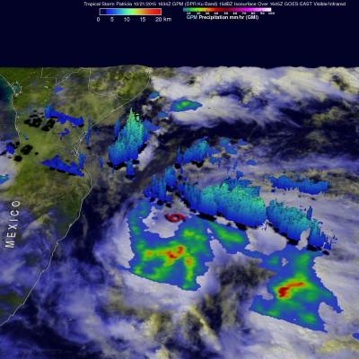
GPM Sees Patricia Becoming A Hurricane

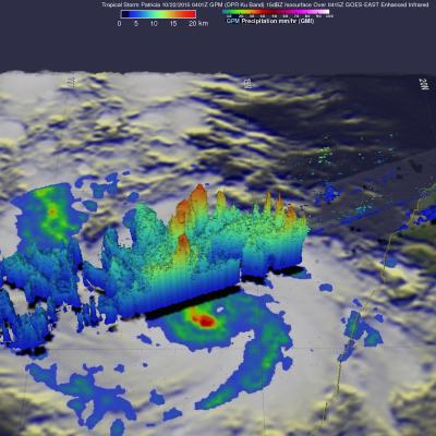
During the night tropical storm Patricia became much better organized and was upgraded to a hurricane. The GPM core observatory satellite flew above the intensifying tropical cyclone on October 22, 2015 at 0401 UTC. Patricia was still a tropical storm with maximum sustained winds estimated at 55 kts (63 mph) at that time but rainfall derived from GPM's Microwave Imager (GMI) and Dual-Frequency Precipitation Radar (DPR) instruments showed that an eye was forming. The National Hurricane Center (NHC) 0400 AM CTD discussion said that, "... 37 GHz GPM image showed a cyan ring around the eye, which

Tropical Storm Patricia Forms Off Mexican Coast

Tropical Depression Twenty-E (TD20E) formed on October 20, 2015 off the Mexican coast southeast of Puerto Escondido, Mexico. Later that evening TD20E was upgraded to tropical storm Patricia. On October 21, 2015 at 1634 UTC (11:34 AM CDT) the GPM core observatory satellite flew over tropical storm Patricia. GPM's Microwave Imager (GMI) instrument had good coverage of the rainfall associated with the tropical storm. Rainfall data derived from GMI are shown overlaid on a GOES-EAST Visible/Infrared image captured at 1645 UTC (11:45 AM CDT). GPM's Dual-Frequency Precipitation Radar (DPR) instrument

GPM Checks on Cat 4 Hurricane Olaf

On October 19, 2015 Hurricane Olaf became the eighth category four hurricane in the busy 2015 Eastern Pacific hurricane season. The GPM core observatory satellite had a good look at the distribution of rainfall around powerful hurricane Olaf on October 20, 2015 at 0716 UTC. At that time Olaf had sustained winds estimated at over 130 kts (150 mph). GPM's Microwave Imager (GMI) and Dual-Frequency Precipitation Radar (DPR) measured the intensity of rainfall within the hurricane. GPM's GMI found rain falling at a rate of over 71.5 mm (2.8 inches) per hour in Olaf's eye wall. The DPR instrument

Typhoon Koppu's Deadly Philippine Rainfall

Extremely heavy rainfall from super typhoon Koppu has caused deadly flooding and mudslides in the Philippines. Koppu hit the eastern coast of Luzon as a category four super typhoon with winds of 130kts (150 mph). Koppu weakened but was still battering the Philippines as a typhoon after reaching the Lingayen Gulf on Luzon's western coast. Typhoon Koppu then made a turn toward the north and continued to drench the northern Philippines as it followed Luzon's northwestern coast. Torrents of rain flowing from mountainous terrain magnified the effects of very high rainfall totals. A rainfall

GPM Measures Tropical Storm Champi's Heavy Rainfall

On October 16, 2015 at 0216 UTC the GPM core observatory satellite passed above tropical storm Champi as it was drenching the northern Mariana Islands. GPM's Dual-Frequency Precipitation Radar (DPR) measured rain within Champi falling at a rate of over 114.8 mm (4.5 inches) per hour in a band of intense showers. GPM's radar sliced through Champi's western side and made 3-D measurements of storm top heights. Radar reflectivity values found to be greater than 15 dBZ are shown in a simulated perspective 3-D view. The lowest Heights are shaded blue and the tallest 3-D 15dBZ surfaces are colored

GPM Views Tropical Depression Twenty Five (25W)

Tropical Depression Twenty Five (TD25W) also formed today. It was located east of Guam and is predicted by the Joint Typhoon Warning Center (JTWC) to move toward the west-northwestward and pass to the north of Guam. TD25W is expected to become a typhoon with maximum sustained winds of 75 kt (86 mph) on October 18, 2015. The GPM core observatory satellite saw TD25W on October 13, 2015 at 1313 UTC. GPM found that TD25W contained moderate to heavy rainfall falling at a rate of up to 67 mm (2.6 inches) per hour. A 3-D image was made using GPM's Dual-Frequency Precipitation Radar (DPR) data where

Tropical Storm Koppu Heads Toward The Philippines

Tropical storm KOPPU that recently formed northwest of Guam in the western Pacific Ocean may threaten the Philippines in the next five days. A recent prediction by the Joint Typhoon Warning Center (JTWC) indicates that tropical storm KOPPU will intensify to typhoon intensity while heading westward toward the northern Philippines. The GPM core observatory satellite flew over tropical storm KOPPU on October 13, 2015 at 0316 UTC. Data collected with GPM's Microwave Imager (GMI) and Dual-Frequency Precipitation Radar (DPR) instruments shows that numerous intense thunderstorms near the tropical

GPM Reveals Very Strong Thunderstorms in Typhoon Choi-Wan

The GPM core observatory satellite flew above tropical storm Choi-Wan on October 5, 2015 at 1828 UTC and then saw Choi-Wan again as a hurricane on October 6, 2015 at 0448 UTC. The tropical cyclone was spreading clouds and rain over a large area of the northwest Pacific Ocean southeast of Japan. GPM discovered that Choi-Wan's organization had slightly improved. GPM's Microwave Imager (GMI) and Dual-Frequency Precipitation Radar (DPR) instruments were able to peer through the overcast and reveal the locations of rainfall bands within the tropical cyclone. GMI found several areas where Choi-Wan