Koppu

Typhoon Koppu's Deadly Philippine Rainfall

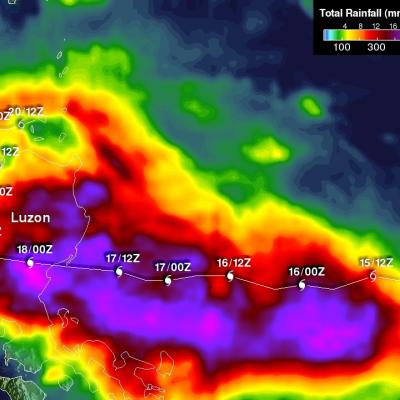
Extremely heavy rainfall from super typhoon Koppu has caused deadly flooding and mudslides in the Philippines. Koppu hit the eastern coast of Luzon as a category four super typhoon with winds of 130kts (150 mph). Koppu weakened but was still battering the Philippines as a typhoon after reaching the Lingayen Gulf on Luzon's western coast. Typhoon Koppu then made a turn toward the north and continued to drench the northern Philippines as it followed Luzon's northwestern coast. Torrents of rain flowing from mountainous terrain magnified the effects of very high rainfall totals. A rainfall

GPM Sees Tropical Storm Koppu Menacing The Philippines

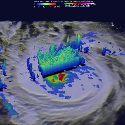
Tropical storm Koppu was approaching the Philippines with sustained winds estimated of 60 kts (69 mph) when the GPM core observatory satellite passed above on October 15, 2015 at 1436 UTC. A rainfall analysis using data collected by GPM's Microwave Imager (GMI) instrument revealed that an eye was very close to forming near Koppu's center of circulation. Rain was measured by GPM's GMI instrument dropping rain at a rate of over 133 mm (5.3 inches) per hour in intense convective thunderstorms just southwest of Koppu's center. Data from GPM's Dual-Frequency Precipitation Radar (DPR) instrument

Tropical Storm Koppu Heads Toward The Philippines

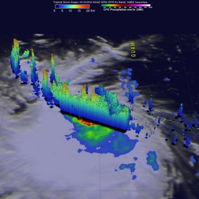
Tropical storm KOPPU that recently formed northwest of Guam in the western Pacific Ocean may threaten the Philippines in the next five days. A recent prediction by the Joint Typhoon Warning Center (JTWC) indicates that tropical storm KOPPU will intensify to typhoon intensity while heading westward toward the northern Philippines. The GPM core observatory satellite flew over tropical storm KOPPU on October 13, 2015 at 0316 UTC. Data collected with GPM's Microwave Imager (GMI) and Dual-Frequency Precipitation Radar (DPR) instruments shows that numerous intense thunderstorms near the tropical