Patricia

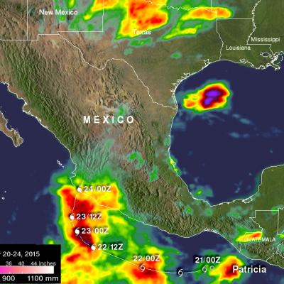
Patricia Remnants Combine With Storm System Over Texas

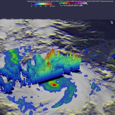
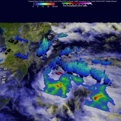
Patricia, the most powerful hurricane on record in the Western Hemisphere, quickly lost power as it moved over Mexico. Then an upper-level low pressure system and the remnants of hurricane Patricia combined to cause very heavy rain in Texas. On Sunday October 25, 2015 eastern Texas, Louisiana and Mississippi were also warned of flooding as extreme rainfall moved eastward along the Gulf Coast.
Hurricane Patricia Makes Landfall in Mexico
The eye of hurricane Patricia hit the Mexican coast on October 23, 2015 at approximately 6:15 PM CDT(2315 UTC)near Cuixmala, Mexico. The maximum winds at that time were estimated to be 143 kts (165 mph). Patricia is weakening rapidly but continued heavy rain is expected to cause flash floods and mudslides in the Mexican states of Nayarit, Jalisco, Colima, Michoacan and Guerrero through Saturday October 24, 2015. Over the weekend the remants of Patricia are also expected to add to the extreme rainfall in Texas. Rainfall from a stalled front that has been causing flooding in northern and central...

GPM Sees Patricia Becoming A Hurricane

During the night tropical storm Patricia became much better organized and was upgraded to a hurricane. The GPM core observatory satellite flew above the intensifying tropical cyclone on October 22, 2015 at 0401 UTC. Patricia was still a tropical storm with maximum sustained winds estimated at 55 kts (63 mph) at that time but rainfall derived from GPM's Microwave Imager (GMI) and Dual-Frequency Precipitation Radar (DPR) instruments showed that an eye was forming. The National Hurricane Center (NHC) 0400 AM CTD discussion said that, "... 37 GHz GPM image showed a cyan ring around the eye, which

Tropical Storm Patricia Forms Off Mexican Coast

Tropical Depression Twenty-E (TD20E) formed on October 20, 2015 off the Mexican coast southeast of Puerto Escondido, Mexico. Later that evening TD20E was upgraded to tropical storm Patricia. On October 21, 2015 at 1634 UTC (11:34 AM CDT) the GPM core observatory satellite flew over tropical storm Patricia. GPM's Microwave Imager (GMI) instrument had good coverage of the rainfall associated with the tropical storm. Rainfall data derived from GMI are shown overlaid on a GOES-EAST Visible/Infrared image captured at 1645 UTC (11:45 AM CDT). GPM's Dual-Frequency Precipitation Radar (DPR) instrument