
GPM Satellite Scans Powerful Tropical Cyclone Hola
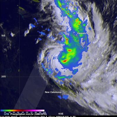
The GPM core observatory satellite had a fairly good look at powerful tropical cyclone HOLA on March 8, 2018 at 0812 UTC. HOLA was located northeast of New Caledonia with maximum sustained winds of about 95 kts (~ 105 mph). The rainfall in this image was derived from data received by GPM's Microwave Imager (GMI) and Dual Frequency Precipitation Radar (DPR) instruments. GPM's GMI provided the best coverage of the tropical cyclone. GMI data indicated that storms within HOLA were dropping rain at a rate of greater than 49 mm (1.9 inches) per hour in the southeast quadrant of the tropical cyclone