Science

OLYMPEX Field Campaign map
The Olympic Mountain Experiment (OLYMPEX) The Olympic Mountain Experiment, or OLYMPEX, was a NASA-led field campaign, which took place on the Olympic Peninsula of Washington State from November 2015 through February 2016. The goal of the campaign was to collect detailed atmospheric measurements that will be used to evaluate how well rain-observing satellites measure rainfall and snowfall from space. In particular, OLYMPEX assessed satellite measurements made by the Global Precipitation Measurement (GPM) mission Core Observatory, a joint mission by NASA and the Japan Aerospace Exploration...
How Does NASA Study Hurricanes?
Hurricanes are the most powerful weather event on Earth. NASA’s expertise in space and scientific exploration contributes to essential services provided to the American people by other federal agencies, such as hurricane weather forecasting. The National Oceanic and Atmospheric Administration and the National Hurricane Center (NHC) use a variety of tools to predict these storms’ paths. These scientists need a wealth of data to accurately forecast hurricanes. NASA satellites, computer modeling, instruments, aircraft and field missions contribute to this mix of information to give scientists a...
A Tale of Two Extremes: Rainfall Across the US
The United States has seen a tale of two extremes this year, with drenching rains in the eastern half of the country and persistent drought in the west. A new visualization of rainfall data collected from space shows the stark contrast between east and west for the first half of 2015. The accumulated precipitation product visualized here begins on Jan. 1, 2015, and runs through July 16, 2015. This visualization shows the heavy rainfall throughout Northern Texas and across Oklahoma as well as the drought in Southern California. Credits: NASA Goddard's Scientific Visualization Studio Download...
California “Rain Debt” Equal to Average Full Year of Precipitation
California's accumulated precipitation “deficit” from 2012 to 2014 shown as a percent change from the 17-year average based on TRMM multi-satellite observations. Credits: NASA/Goddard Scientific Visualization Studio A new NASA study has concluded California accumulated a debt of about 20 inches of precipitation between 2012 and 2015 -- the average amount expected to fall in the state in a single year. The deficit was driven primarily by a lack of air currents moving inland from the Pacific Ocean that are rich in water vapor. In an average year, 20 to 50 percent of California's precipitation...
IPHEx Campaign Demonstrates Two New Instruments
Three Radars are Better than One Putting three radars on a plane to measure rainfall may seem like overkill. But for the Integrated Precipitation and Hydrology Experiment field campaign in North Carolina recently, more definitely was better. During the field campaign, NASA's ER-2 research aircraft flew out of Robins Air Force Base in Georgia. HIWRAP is under the wing in the black compartment; the Cloud Radar System is under the other wing and is not visible; and the EXRAD radar is in the extended nose cone. Image Credit: NASA / Gerry Heymsfield The three instruments, developed by the High...
NASA Widens 2014 Hurricane Research Mission
NASA's airborne Hurricane and Severe Storm Sentinel or HS3 mission, will revisit the Atlantic Ocean for the third year in a row. Image Credit: NASA's Goddard Space Flight Center/Ryan Fitzgibbons Download this video in HD formats from NASA Goddard's Scientific Visualization Studio During this year's Atlantic hurricane season, NASA is redoubling its efforts to probe the inner workings of hurricanes and tropical storms with two unmanned Global Hawk aircraft flying over storms and two new space-based missions. NASA's airborne Hurricane and Severe Storm Sentinel or HS3 mission, will revisit the...
NASA Begins IPHEx Field Campaign
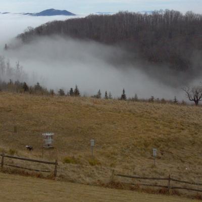
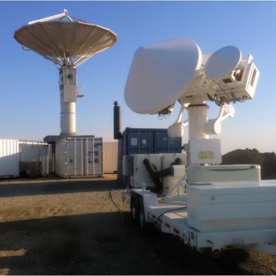
Rain, ice, hail, severe winds, thunderstorms, and heavy fog – the Appalachian Mountains in the southeast United States have it all. On May 1, NASA begins a campaign in western North Carolina to better understand the difficult-to-predict weather patterns of mountain regions. The field campaign serves as ground truth for measurements made by the Global Precipitation Measurement (GPM) mission's Core Observatory. GPM is an international satellite mission to observe rain and snow around the world. The advanced instruments on the GPM Core Observatory satellite, launched Feb. 27, provide the next...
DROP field campaign instruments
Integrated Precipitation and Hydrology EXperiment The Integrated Precipitation and Hydrology Experiment (IPHEx) is a ground validation field campaign that will take place in the southern Appalachian Mountains in the eastern United States from May 1 to June 15, 2014. IPHEx is co-led by NASA's Global Precipitation Measurement mission, with partners at Duke University and NOAA's Hydrometerological Testbed. The field campaign has two primary goals. The first is to evaluate how well observations from precipitation-monitoring satellites, including the recently launched GPM Core Observatory, match up...
Ground validation radars.
The Global Precipitation Measurement (GPM) Core Observatory, launched on Feb. 27, 2015, from Tanegashima Space Center in Japan, will help advance our understanding of Earth's water and energy cycles, improve the forecasting of extreme events that cause natural disasters, and extend current capabilities of using satellite precipitation information to directly benefit society. The GPM mission will provide unprecedented data on rain and snowfall. The science instruments on the GPM Core Observatory will provide data that will yield the greatest clarity on rain and snow yet gathered from orbiting...
PMM Article Image
When asked to picture the shape of raindrops, many of us will imagine water looking like tears that fall from our eyes, or the stretched out drip from a leaky faucet. This popular misconception is often reinforced in weather imagery associated with predictions and forecasts. Raindrops are actually shaped like the top of a hamburger bun, round on the top and flat on the bottom. A new video from the Global Precipitation Measurement mission explains why. This short video explains how a raindrop falls through the atmosphere and why a more accurate look at raindrops can improve estimates of global...