Hide Date

IMERG Early Run Example January 24th, 2020
PMM Science Banner
Photograph of a landslide on a mountain.
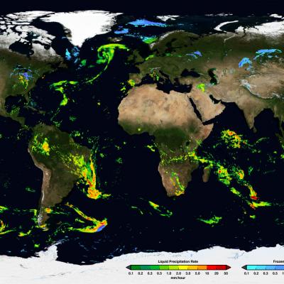
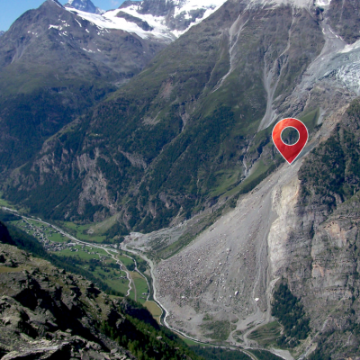
Landslides are a widespread and often underestimated natural hazard, causing thousands of deaths and significant economic damage each year. They routinely block roads, destroy infrastructure, and disrupt communities. Intense or prolonged rainfall is the most common landslide trigger, but earthquakes and human activities can also cause them. Using satellite data, models, and citizen science reports, NASA researchers have developed a collection of tools and datasets to improve our understanding of landslides and help communities around the world monitor, predict, and respond to these destructive events.
Thumbnail
PMM Science Banner
3D Printed GPM Data  from Typhoon Malakas
Overview Precipitation data from the Global Precipitation Measurement mission (GPM) was used to generate these 3D printed models of various tropical cyclones and storm systems from the past several years. This data was collected by GPM's Dual-frequency Precipitation Radar instrument, which utilizes Ka-band and Ku-band frequencies to measure the size, shape, and distribution of liquid and solid water particles within clouds in three dimensions. The raw radar data was then processed by algorithms at NASA's Precipitation Processing System to be converted to precipitation rates, then was further
IMERG Early Run Example January 24th, 2020
Thumbnail
GPM Precipitation and Applications Viewer This page is a demonstration of the PMM Precipitation and Applications Publisher API. To learn how to use the API for your own applications, please visit: https://pmmpublisher.pps.eosdis.nasa.gov/ https://pmmpublisher.pps.eosdis.nasa.gov/docs For More Information On: the GPM Precipitation products, please see: https://gpm.nasa.gov/data/directory the Global Landslide Nowcast, please visit: https://gpm.nasa.gov/applications/landslides LOADING Show Legends Show Controls Select Region: North America Central America South America Europe Africa Middle East
IMERG Early Run Example January 24th, 2020
GPM & TRMM Data Usage Policy GPM and TRMM data are freely available at all levels for which the particular sensor or sensor combination has been processed by GPM. For the GPM Core Observatory this is for Levels 0 through 3 products (as applicable). For the partner satellites in the GPM constellation this is Levels 1c through 3 (as applicable). Users are encouraged to access data from the primary GPM and TRMM archives (i.e. nasa.gov domains at Goddard Space Flight Center). When data from secondary archives are used, it is incumbent on the user to verify that the data values accessed are
IMERG Early Run Example January 24th, 2020