
María Paula Hobouchian - Analysis, Validation, and Correction of Satellite Quantitative Precipitation Estimation (SQPE) in Argentina
Overview: Argentina has a low-density rain gauge network. As a result, there are often challenges in representing accurate estimates of precipitation. Satellite quantitative precipitation estimates (SQPEs) derived from satellite measurements can help fill these gaps and serve a critical role in hydrological and weather forecasting applications. This project explores different gauge bias correction methods of SQPE products using the IMERG Early Run in Argentina to improve SQPE data products.
Mentor: Joe Turk
2022 GPM Mentorship Program
María Paula Hobouchian - Analysis, Validation, and Correction of Satellite Quantitative Precipitation Estimation (SQPE) in Argentina
Participant Name: María Paula Hobouchian
Project: Analysis, Validation, and Correction of Satellite Quantitative Precipitation Estimation (SQPE) in Argentina
Affiliation: National Meteorological Service of Argentina
Current role: Researcher in Remote Sensing Products
Mentor: Joe Turk
Download Project Overview Highlights (.pptx)
Download Final Presentation (.pdf)
Why are you participating in this program?
I heard about this opportunity by the International Precipitation Working Group mail list. I was especially interested in satellite precipitation product applications, bias correction, and early flash flood detection.
Tell us about your project.
Argentina has a low-density rain gauge network. As a result, there are often challenges in representing accurate estimates of precipitation. Satellite quantitative precipitation estimates (SQPEs) derived from satellite measurements can help fill these gaps and serve a critical role in hydrological and weather forecasting applications over a wide range of spatiotemporal scales. This data is often used as input to hydrological models and serves as a basis for meteorological watches and warnings for the early detection of flash flood events. While using SQPEs has advantages, it is necessary to make BIAS corrections to these estimates to improve data products to the greatest extent.
For this project, we explored different gauge bias correction methods of SQPE products using the IMERG Early Run in Argentina to improve SQPE data products. Currently, the National Meteorological Service in Argentina has a daily gauge-corrected SQPE product based on a historical PDF-matching method (Gudmundsson et al., 2012) by region and three-month period, using the daily IMERG Early Run and the high-quality network since 2001. After that, the local BIAS correction (Zhang et al., 2011) applies an inverse distance weight (IDW) technique by region, using the daily IMERG Early Run first corrected with PDF-matching, the complete rain gauge network, and a spatial consistency method. During the project guide period, the objective was to evaluate an alternative suggested method by mentors to improve the current Gauge-corrected SQPE product in Argentina.
The project is still ongoing, and we expect to include a comparison of the current local bias correction by the IDW technique and the Kriging with External Drift (KED) technique. The activities considered are adapting code, practice, and discussion of the methods. Also, the results considered are computing summary statistics and mapping daily precipitation for heavy rainfall events in Argentina. These methods for improving SQPE products can provide better daily precipitation estimates in regions with a sparse rain gauge network, providing valuable information for meteorological agencies such as the National Meteorological Service in Argentina.
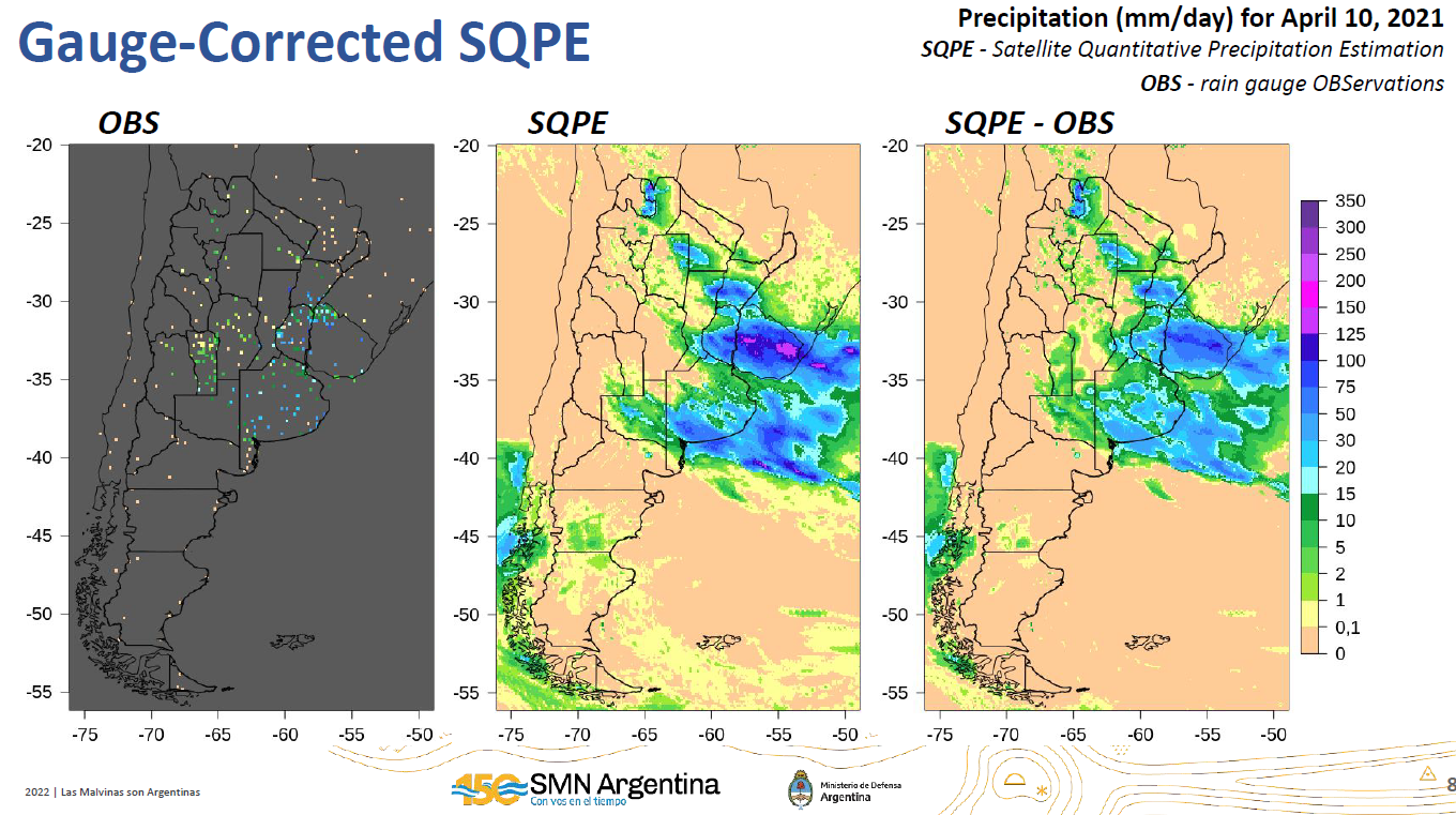
Evaluating alternative methods using rain gauge observations and SQPE products to improve precipitation estimates in Argentina. Credits: MP Hobouchian
What communities or organizations may benefit from your case study project?
The National Meteorological Service in Argentina and any internal and external users of precipitation data.
What is something surprising that you have learned about the GPM mission, the data, or applying GPM data for applications?
User applications and bias correction techniques.
What is a challenge you faced with using remote sensing data? Any lessons learned that helped overcome this barrier?
Overestimation of precipitation. The goal to improve this limitation with bias corrections is of value for regions like Argentina.
How do you plan to use GPM in the future?
The idea is to use the progress of these satellite precipitation products as the base of a regional gauge-corrected satellite product.