

Armand Kablan - Evaluating Extreme Precipitation Events Over West Africa using GPM DPR
Overview: Extreme precipitation events have caused catastrophic flooding throughout West Africa and will continue to wreak havoc over these parts as the climate continues to change. For this project, I am analyzing monthly convective shallow, deep convective and stratiform events over the West Africa region and comparing rainfall totals using GPM DPR data.
Mentors: Aaron Funk, Courtney Schumacher
2022 GPM Mentorship Program
Armand Kablan - Evaluating Extreme Precipitation Events Over West Africa using GPM DPR

Participant Name: Armand Kablan
Project: Evaluating Extreme Precipitation Events Over West Africa using GPM DPR
Affiliation: Université Félix Houphouët-Boigny, Abidjan, Côte d'Ivoire
Current role: Lecturer-Researcher
Mentors: Aaron Funk, Courtney Schumacher
Download Project Overview Highlights (.pptx)
Download Final Presentation (.pdf)
Why are you participating in this program?
I am participating in this program because I wanted to know how satellite precipitation measurements from the GPM mission can help in dealing with flooding in urban areas. I was attracted by the use of satellite images that have a good spatial resolution.
Tell us about your project
Extreme precipitation events have caused catastrophic flooding throughout West Africa and will continue to wreak havoc over these parts as the climate continues to change. Understanding what types of extreme rainfall events from convective non-shallow to stratiform to convective shallow events contribute to intense flooding over the West African southern coast can help significantly improve disaster response and mitigation efforts over this region.
For this project, I am analyzing monthly convective shallow, deep convective and stratiform events over the West Africa region and comparing rainfall totals using GPM DPR data. Results show that convective shallow, deep convective and stratiform events are highly represented over the West African southern coast. All three rain types contribute to high rainfall over the south part of Cote d'Ivoire.
However, deep convective rain is the main contributor to intense floods over the southern coast during the months of May and June, demonstrating a flood critical period from May 29 to June 18. That period combines high daily rainfall frequency and intensity.
Understanding more about how deep convective events play a role in contributing to severe flooding over West African urban areas can help enable the scientific community and policy planners in West African governments to build an effective flood early warning system and make informed decisions for extreme weather events and weather and climate mitigation efforts.
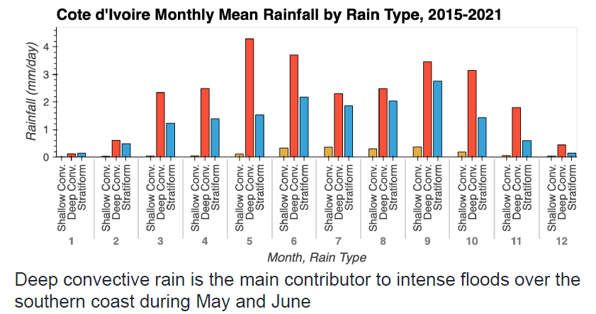
An analysis of monthly convective shallow, deep convective and stratiform events over the West Africa region against rainfall totals using GPM DPR data. Credits: A Kablan
What communities or organizations may benefit from your case study project?
My work will benefit researchers and West African governments.
What is something surprising that you have learned about the GPM mission, the data, or applying GPM data for applications?
I have learned how python can help to analyze satellite data and that data are available for free.
What is a challenge you faced with using remote sensing data? Any lessons learned that helped overcome this barrier?
The big challenge I faced is the use of Python for GPM data analysis. My mentors helped me to install Python library.
How do you plan to use GPM in the future?
I will use information learned for dealing with flooding events over urban West Africa.