Ayuna Santika - Convective Rainfall and AOD in Central Kalimantan, Indonesia
Overview: Understanding the relationship between aerosols and the fuel that govern deep convective storm events can significantly improve meteorologists’ and scientific researchers’ capacity to predict and monitor these severe weather events. For this project, I am analyzing shallow, deep convective and stratiform events over Central Kalimantan using GPM DPR data and comparing it to the amount of atmospheric aerosols using AOD retrievals from ground based measurements provided by AERONET.
Mentors: Aaron Funk, Courtney Schumacher
2022 GPM Mentorship Program
Ayuna Santika - Convective Rainfall and AOD in Central Kalimantan, Indonesia
Participant Name: Ayuna Santika
Project: Convective Rainfall and AOD in Central Kalimantan, Indonesia
Affiliation: Meteorology Climatology and Geophysics Agency of Indonesia (BMKG)
Current role: Staff in Air Quality Division of BMKG
Mentors: Aaron Funk, Courtney Schumacher
Download Project Overview Highlights (.pptx)
Download Final Presentation (.pdf)
Why are you participating in this program?
I want to know more about precipitation data (especially precipitation data in tropical areas such as Indonesia) including the ground observation data, satellite data, and modelling data.
Tell us about your project
Deep convective rainfall (e.g., storms that produce heavy rain, hail and wind) is a common occurrence within the Central Kalimantan region of Indonesia. This region also becomes an area where huge wildfires often happen, especially during the dry season in which aerosols can impact the forming of convective clouds. Previous studies have shown that Aerosol Optical Depths (AOD) and rainfall correlate significantly. Understanding the relationship between aerosols and the fuel that govern these convective storm events can significantly improve meteorologists’ and scientific researchers’ capacity to predict and monitor these severe weather events.
For this project, I am analyzing shallow, deep convective and stratiform events over Central Kalimantan using GPM DPR data and comparing it to the amount of atmospheric aerosols using AOD retrievals from ground based measurements provided by AERONET.
Coordinates used to represent Central Kalimantan are 0°45’ N - 3°30’ S and 111° E - 116° E. Meanwhile the location of AERONET is in Palangkaraya (center of Central Kalimantan with coordinates 2.23°S,113.94°E). The period of both GPM DPR data and AERONET data is in the year of 2015 dataset which is then analyzed annually and monthly.
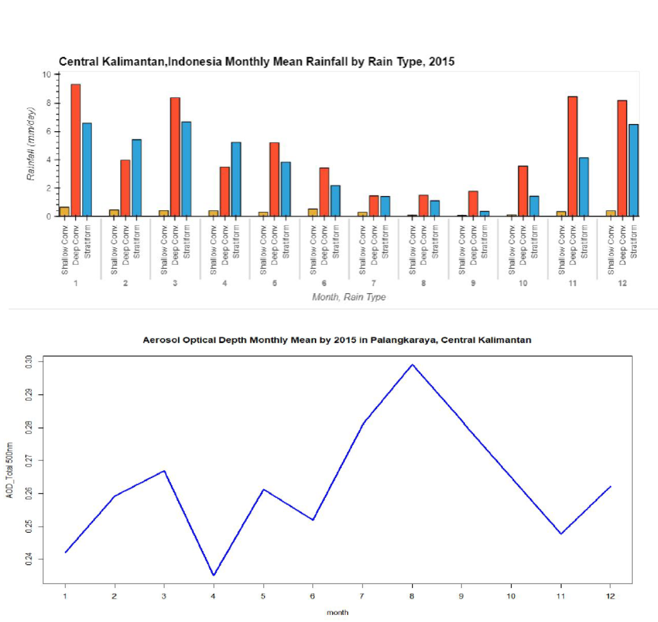
Central Kalimantan has a unique characteristic of convective clouds. Project findings show that in 2015 convective non-shallow rainfall (deep convective) dominated Central Kalimantan rainfall types. Furthermore, a high rainfall amount is generally distributed in the north-west part of Central Kalimantan which is located near the equator. Additionally, monthly brief analysis of convective types in this region were conducted to understand the pattern of rainfall. Based on monthly mean rainfall by rain type in 2015, Central Kalimantan has a monsoonal rainfall pattern in which both wet season and dry season are dominated by deep convective rainfall events.
Moreover, as the formation of clouds is also impacted by the occurrence of aerosols, this project also focused on identifying the correlation between AOD 500nm and convective cloud types. The result of this study reveals that lower AOD is observed in the wet season when high amounts of rainfall and deep convective clouds reach their peak in Nov-May. Lower AOD in Nov-Jan appears linked to enhanced deep convective rainfall. Meanwhile, AOD starts to increase from June until September and hits the high mean value in August. It occurs when the deep convective clouds are at their lowest point during July until October. Otherwise, high stratiform rainfall occurs when AOD is at its lowest peak in April.
This type of analysis provides an opportunity for the BMKG (Met Agency of Indonesia) to understand more about the relationships among active fires, AOD and convective rainfall events throughout the Central Kalimantan region, giving stakeholders such as the BMKG information that can be used to understand more and improve prediction of extreme weather in the area.
What communities or organizations may benefit from your case study project?
I work within the air quality division under the Applied Climatology Centre, so it means many users will need our information. The agency works with government institutions, communities, and users to provide applied climatological information, which precipitation is an important component for this work. As such, this program was very practical and applicable in my work environment.
What is something surprising that you have learned about the GPM mission, the data, or applying GPM data for applications?
I am a lucky person because I was partnered with PMM scientists who are very knowledgeable about GPM’s DPR and DPR data products. Working with my mentors, I learned that GPM mission can provide precipitation information based on convective cloud types. This can be a great opportunity for us at the BMKG to enhance other applications.
What is a challenge you faced with using remote sensing data? Any lessons learned that helped overcome this barrier?
The biggest challenge is processing the data. Programming skill is highly needed to process the data into information or visualization.
How do you plan to use GPM in the future?
I plan to explore more about GPM datasets, and would like to conduct more research about precipitation patterns in Indonesia and the interconnection of precipitation with air quality in Indonesia.


