Odinakachukwu Echeta - Ground Validation Analysis of GPM DPR Product
Overview: This project works to validate the GPM dual-frequency precipitation radar (DPR) merged scan product against a quality-controlled ground reference data (GV-MRMS) in the continental US. Knowledge from this concept study will be applied to validating/ evaluating and selecting remotely-sensed satellite rainfall products that could be useful for rainfall estimation in data-scarce regions such as West Africa.
Mentors: Yagmur Derin, Pierre Kirstetter
2022 GPM Mentorship Program
Odinakachukwu Echeta - Ground Validation Analysis of GPM DPR Product
Participant Name: Odinakachukwu Echeta
Project: Ground Validation Analysis of GPM DPR Product
Affiliation: Kwame Nkrumah University of Science and Technology, Kumasi-Ghana
Current role: PhD student
Mentors: Yagmur Derin, Pierre Kirstetter
Download Project Overview Highlights (.pptx)
Download Final Presentation (.pdf)
Why are you participating in this program?
When I was researching literature for my MSc project, I became intrigued by the idea of using satellites to estimate rainfall. Prior to that, I had attempted to obtain precipitation and streamflow data from appropriate government institutions, but the data presented numerous challenges. Due to the agencies' limited budgets, it was impossible for them to have a good distribution of gauges. Even if a basin had a fairly even distribution of gauges, the resources required to monitor them, particularly those in remote and difficult-to-reach locations, posed a challenge. As a result, I was ecstatic when I discovered, while reading published scientific research, that highly spatio-temporal rainfall data (obtained via satellite remote sensing) could be obtained for free and decided to investigate this further in my PhD.
Despite what I'd learned from satellite rainfall validation analysis prior to the program, I was convinced there was still a lot I didn't know about satellite rainfall products. So when I learned about the GPM Mentorship Program, it piqued my interest. I expected it to help me gain a better understanding of satellite products and their potential, particularly GPM products, and I was right!
Tell us about your project
While surface rain gauges and ground radar are more traditional methods for estimating precipitation, their overall distributions are relatively limited, and this data is frequently difficult to obtain. Satellite observations, on the other hand, can help provide coverage to support and monitor precipitation over regions, and datasets such as NASA GPM are freely and publicly available to support a wide range of societal applications (such as hydrological modeling). While satellite data has advantages, it is critical to assess its quality over any region before using it for the desired mode of application.
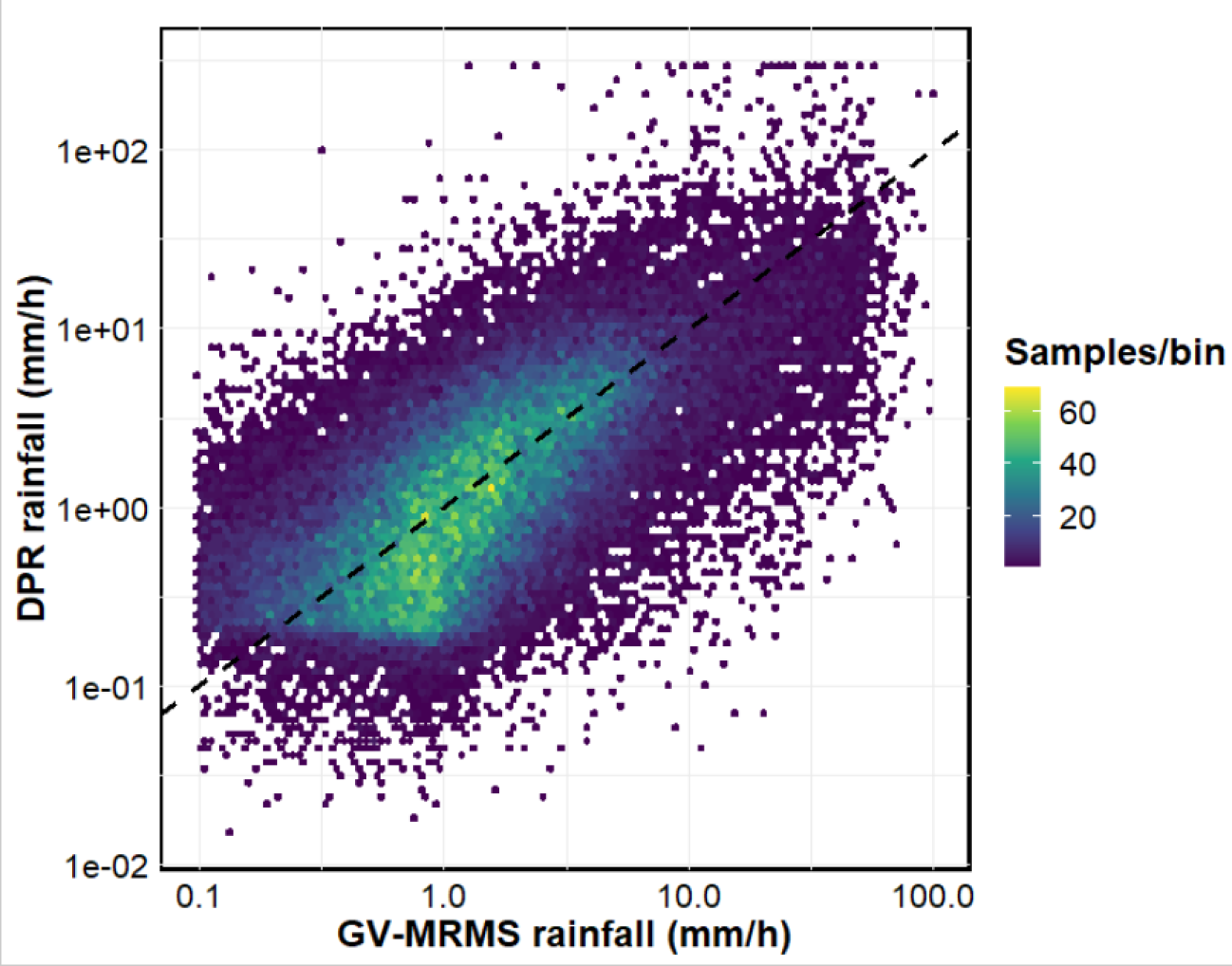
For this project, I am validating the GPM dual-frequency precipitation radar (DPR) merged scan product against a quality-controlled ground reference data (GV-MRMS) in the continental US – (GVMRMS rain/no rain threshold was set as 0.1 mm/h and only radar quality index of 100 is considered). Knowledge from this concept study will be applied to validating/ evaluating and selecting remotely-sensed satellite rainfall products that could be useful for rainfall estimation in data-scarce regions such as West Africa.
In order to assess data quality, quantification and detection analyses were carried out. First, the relationship between both datasets was determined using a density scatter plot. Afterwards, the accuracy and rainfall detection skill of DPR was evaluated using several categorical (such as hits, misses and false detection) and statistical (mean relative error) metrics. Furthermore, the mean relative error of different Convective Volume Contribution (CVC) classes was estimated.
Project findings include:
- The most frequently occurring rainfall intensities in the region were below 10 mm h-1.
- DPR correctly detected rainfall over 70% of the time, but missed 25% of the rainfall events. However, the likelihood of DPR to falsely detect rainfall is less than 5%.
- DPR predominantly over-estimated lower intensity rainfall (R ≤ 10 mm h-1), with the maximum over-estimation (> 40%) recorded at R ≤ 0.5 mm h-1. When rainfall intensities were greater than 20 mm h-1, DPR greatly under-estimated rainfall.
- For stratiform type rainfall (CVC = 0), DPR recorded the least value of MRE. As CVC increased from 0 to 30%, rainfall over-estimation was recorded. However, DPR under-estimated rainfall at higher thresholds (CVC > 80%); primarily due to radar signal attenuation.
- Understanding how to evaluate the accuracy of satellite precipitation data against ground data as well as accurately select the appropriate satellite precipitation estimate can greatly improve precipitation estimation over a given region. As a result of this, valuable information for improved weather and climate forecasts needed by meteorological, hydrological and disaster management bodies can be provided.
What communities or organizations may benefit from your case study project?
Meteorological and hydrological organizations in West Africa. Furthermore, disaster management bodies such as flood risk assessment and forecasting organizations are potential beneficiaries.
What is something surprising that you have learned about the GPM mission, the data, or applying GPM data for applications?
The potential use of GPM products within landslide forecasting models came as a surprise. I was also surprised to learn that the GPM product - Dual-frequency Precipitation Radar (DPR) - provides information on the type of rainfall that occurred, whether convective or stratiform.
What is a challenge you faced with using remote sensing data? Any lessons learned that helped overcome this barrier?
One of the difficulties with using remote sensing data is that because they are not direct measurements, remotely sensed rainfall data is prone to errors. During the mentorship program, however, I learned that a relatively effective way of adjusting/applying bias correction to satellite rainfall estimates is to ensure that there are enough raining samples, not just total boxes.
How do you plan to use GPM in the future?
I intend to investigate the potential of various GPM products to supplement ground-measured rainfall in regions such as West Africa, with the goal of using GPM products for hydrological modeling and possibly flood risk management in the region.


