Summer Monsoon Season Ends in India
The Indian summer monsoon, also known as the southwest monsoon, falls within the South Asian monsoon and is the strongest and perhaps best-known of the world’s monsoons. During summer months when the Asian landmass heats up, warm, moist air flows northward from the Indian Ocean towards the Himalayas, bringing abundant showers and thundershowers to India. The summer monsoon is a regular event that occurs every year and is responsible for roughly 80% of India’s annual rainfall. The summer monsoon typically starts in early June, peaks in July and August and winds down during September and early October.
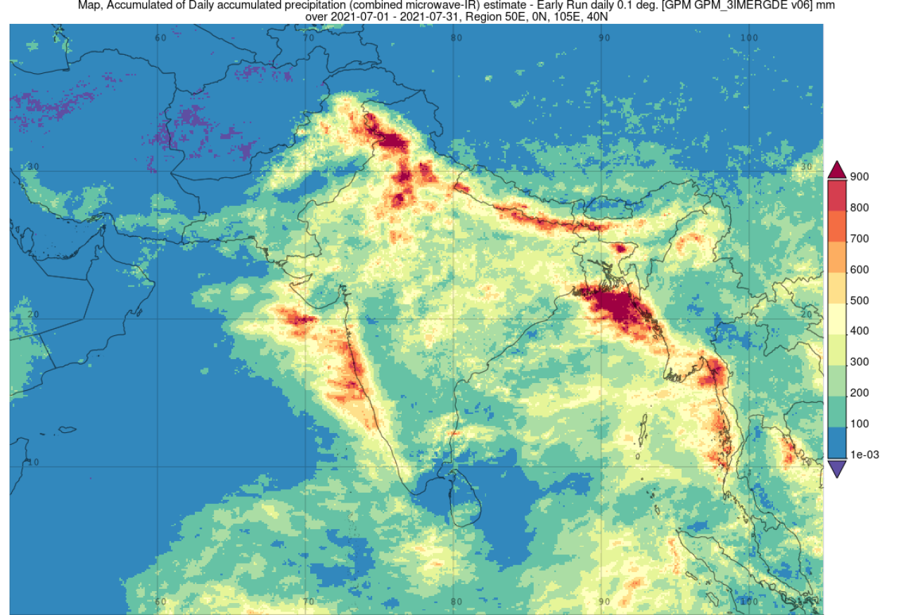
Surface rainfall accumulations from NASA’s IMERG precipitation product are shown here for the month of July 2021 from this past summer over India and the surrounding region during the peak of the summer monsoon. IMERG shows the highest rainfall totals for the period are located over the foothills of the Himalayas with rainfall amounts generally in excess of 600 to 900 mm (~24 to 36 inches, shown in orange and dark red) stretching from far northern India near the border with Pakistan southeastward along the border with Nepal and across northern Bangladesh. Another swath of enhanced rainfall runs along the western coast of peninsular India where the Western Ghats, a coastal mountain range, intercept the moist air flowing in from the Arabian Sea. Here amounts are lower than along the Himalayas but still on the order of 400 mm (~16 inches, yellow) to 800 mm (~32 inches, red). Away from these mountain ranges, IMERG shows that the vast majority of the interior received between 200 mm (~8 inches, lighter green) to 300 mm (~12 inches, yellowgreen) with locally higher amounts. The lowest amounts, around 100 mm (~4 inches, green), occur in the lee of the Western Ghats. Outside of India, heavy rainfall also fell over coastal Bangladesh and coastal Myanmar (Burma) along the northeast sections of the Bay of Bengal.
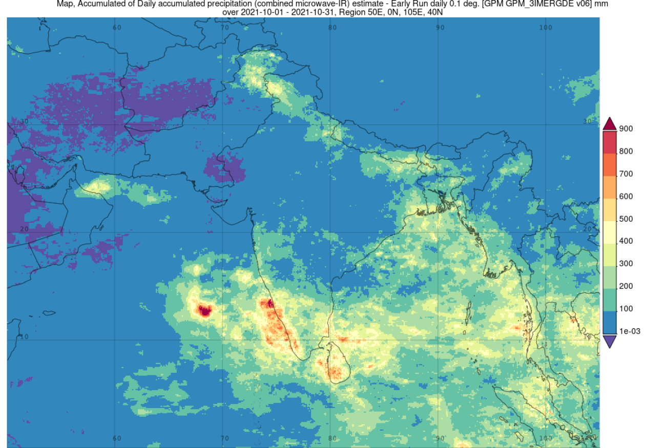
Just as it starts, so too does the summer monsoon come to an end as the Asian continent cools in the fall. The monsoon typically weakens and begins to recede southward in September with October being a transition month as winds shift from southwesterly to northeasterly. As this happens, rainfall is greatly diminished as warm moisture laden air flowing in from the Indian Ocean is replaced by cool dry air flowing down from the Tibetan Plateau and interior. IMERG rainfall accumulations for the month of October 2021 show greatly reduced rainfall amounts across the vast majority of central and northern India with amounts largely below 100 mm (~4 inches, blue). However, rainfall across the southern peninsular region was still significant where the northeast monsoon had yet to penetrate.
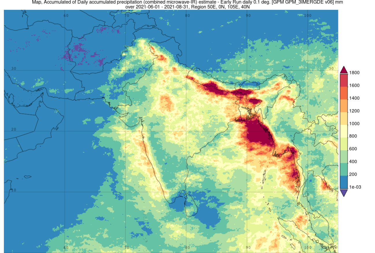
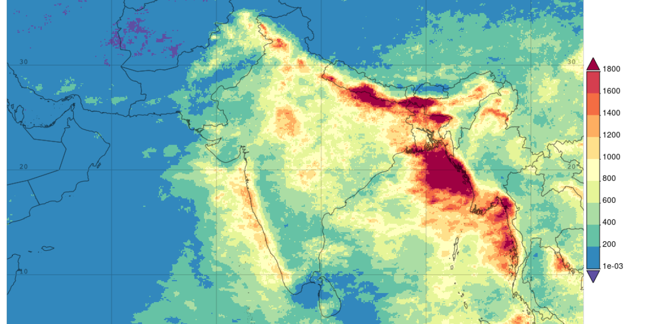
IMERG rainfall accumulations for the entire June-July-August period of 2021 show substantial amounts of rain across nearly all of India during the heart of the monsoon with rainfall totals well exceeding 1800 mm (71 inches, dark red) along the front range of the Himalayas and coastal sections of the Bay of Bengal; only the southern tip of peninsular India did not receive at least 200 mm of rain (< ~8 inches, shown in blue). The overall pattern is quite similar to that for the month of July except that the highest accumulations along the front range of the Himalayas are distinctly located along the eastern sections near the borders with Nepal and Bangladesh. Enhanced areas of rain in the central part of the country where totals exceed 1000 mm (~40 inches, light orange) are likely the result of low pressure centers drifting inland from the Bay of Bengal.
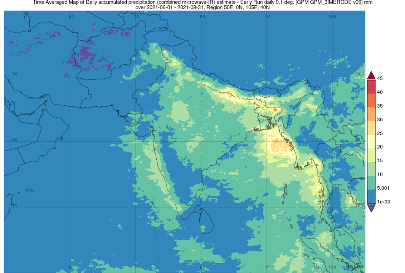
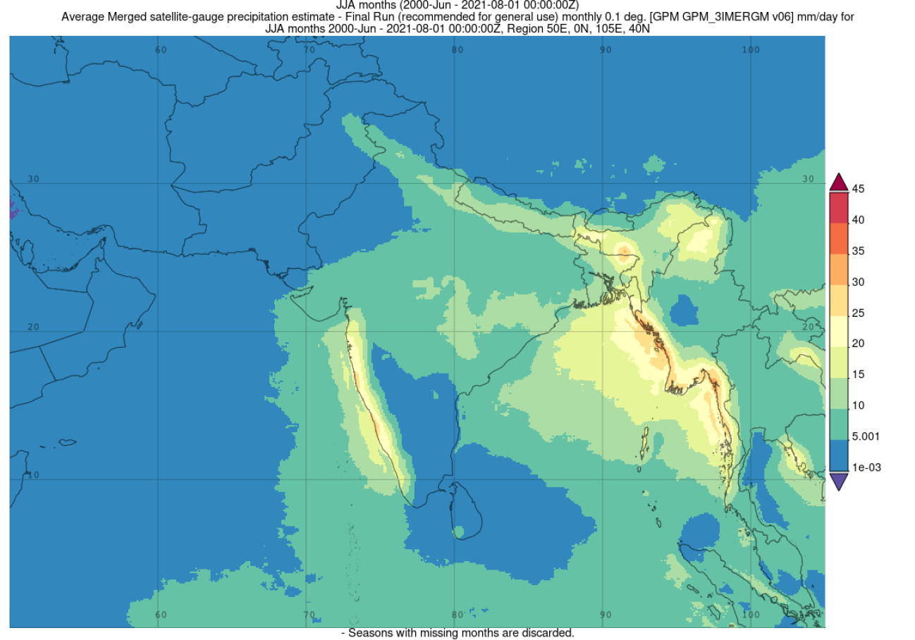
The final two images show average daily rainfall for the monsoon during the summer months of June-July-August for this past 2021 season (above image) versus the long-term average or climatology over the past 21 years (2000 to 2021, below image). The overall pattern of enhanced rainfall along the Western Ghats, southern Himalayas, and west coast of Myanmar in the northeastern Bay of Bengal is quite similar due to the regularity and broadly similar flow features of the monsoon imposed on the fixed, prominent geographic and orographic features. However, there can be substantial variations in the monsoon from year to year as well as within a monsoon season itself as a result of ENSO (the El Nino-Southern Oscillation) effects, the Indian Ocean Dipole, the Madden-Julian Oscillation, climate trends and other factors. IMERG estimates show that for 2021 there was less than average rainfall over the Western Ghats and northeast coast and above average rainfall along the central southern Himalayas near Nepal but less than average rainfall further east over northern Myanmar and far eastern India during the peak summer months. Collectively, rainfall analysis from the India Meteorological Department (IMD) shows that the 2021 monsoon season (June through September) was almost perfectly average. However, seasonal averages can mask the details. IMD time varying rainfall amounts for India show that average rainfall during August was well below normal but was compensated for by well above average rainfall in September due to a later than average withdrawal of the southwest monsoon. In addition, regional averages for the season show well below average rainfall in far eastern India north of Burma and along the central and northeast coast along the Bay of Bengal balanced by well above normal rainfall over the central southern Himalayas and southern peninsular India, showing that 2021 was not that normal after all.


